


<< Our Photo Pages >> Reask - Early Christian Sculptured Stone in Ireland (Republic of) in Co. Kerry
Submitted by Sunny100 on Saturday, 25 September 2004 Page Views: 6064
Early Medieval (Dark Age)Site Name: ReaskCountry: Ireland (Republic of)
NOTE: This site is 0.239 km away from the location you searched for.
County: Co. Kerry Type: Early Christian Sculptured Stone
Map Ref: Q367046
Discovery Map Number: D70
Latitude: 52.169527N Longitude: 10.387603W
Condition:
| 5 | Perfect |
| 4 | Almost Perfect |
| 3 | Reasonable but with some damage |
| 2 | Ruined but still recognisable as an ancient site |
| 1 | Pretty much destroyed, possibly visible as crop marks |
| 0 | No data. |
| -1 | Completely destroyed |
| 5 | Superb |
| 4 | Good |
| 3 | Ordinary |
| 2 | Not Good |
| 1 | Awful |
| 0 | No data. |
| 5 | Can be driven to, probably with disabled access |
| 4 | Short walk on a footpath |
| 3 | Requiring a bit more of a walk |
| 2 | A long walk |
| 1 | In the middle of nowhere, a nightmare to find |
| 0 | No data. |
| 5 | co-ordinates taken by GPS or official recorded co-ordinates |
| 4 | co-ordinates scaled from a detailed map |
| 3 | co-ordinates scaled from a bad map |
| 2 | co-ordinates of the nearest village |
| 1 | co-ordinates of the nearest town |
| 0 | no data |
Internal Links:
External Links:
I have visited· I would like to visit
X-Ice visited on 4th Aug 1982 - their rating: Cond: 3 Amb: 5 Access: 5
")
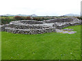
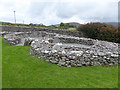
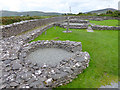
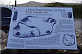
This pillar measures 0.8 metres in height and is 0.4 metres wide by 0.2 metres thick. Its origin has been estimated by radio-carbon dating as having been between 385 ± 90 a.d. The stone was decorated in early Christian times (c. 7th century) with a Latin cross coupled with bifurcated terminals. The ogham text, set sideways to the cross, reads 'DNE' - D(omi)ne - O Lord. Standing stones were often decorated by early Christians, primarily to disguise their pagan origins.
Source: Wikipedia
You may be viewing yesterday's version of this page. To see the most up to date information please register for a free account.
Do not use the above information on other web sites or publications without permission of the contributor.
Nearby Images from Geograph Britain and Ireland:
©2005(licence)
©2015(licence)
©2015(licence)
©2015(licence)
©2018(licence)
The above images may not be of the site on this page, they are loaded from Geograph.
Please Submit an Image of this site or go out and take one for us!
Click here to see more info for this site
Nearby sites
Click here to view sites on an interactive map of the areaKey: Red: member's photo, Blue: 3rd party photo, Yellow: other image, Green: no photo - please go there and take one, Grey: site destroyed
Download sites to:
KML (Google Earth)
GPX (GPS waypoints)
CSV (Garmin/Navman)
CSV (Excel)
To unlock full downloads you need to sign up as a Contributory Member. Otherwise downloads are limited to 50 sites.
Turn off the page maps and other distractions
Nearby sites listing. In the following links * = Image available
852m WSW 248° Ballineanig-Castlequarter Standing Stones (Q359043)
1.0km N 359° Baile an Reannaigh ogham stone* Ancient Village or Settlement
1.7km WSW 238° Altóir na Gréine* Wedge Tomb
2.3km ESE 115° Leataoibh Meánach standing stone* Standing Stone (Menhir)
2.5km E 81° Gallarus Oratory* Ancient Temple (Q392049)
2.8km WSW 250° Teeravane Stone Circle (Q340037)
3.5km ENE 72° Cathair Deargáin cashel* Stone Fort or Dun
3.5km SE 145° Kilcolman Cross-Inscribed Ogham Stone* Early Christian Sculptured Stone (Q386017)
3.8km SSE 158° Giant's Table* Wedge Tomb (Q3801)
3.9km ENE 64° Cill Maoilchéadair sundial* Early Christian Sculptured Stone
3.9km ENE 63° Kilmalkedar Early Christian Sculptured Stone* Early Christian Sculptured Stone (Q40230622)
3.9km ENE 64° Kilmalkedar Ogham Stone* Standing Stone (Menhir) (Q403062)
5.1km ENE 59° Corr Aille Spiral* Rock Art
5.4km WSW 254° Clogher Stone Row / Alignment (Q314033)
5.8km ESE 102° Kilfountain Cross Slab* Early Christian Sculptured Stone (Q423032)
5.9km E 91° Knockavrogeen E Standing Stones (Q42580434)
5.9km E 99° Kilfountan Standing Stone* Standing Stone (Menhir) (Q425035)
7.1km ESE 117° Milltown N* Standing Stones (Q42960113)
7.1km ESE 118° Milltown S Standing Stones (Q429010)
7.2km ESE 118° Gallán na Cille Brice standing stone* Standing Stone (Menhir)
7.2km ESE 117° Baile an Mhuilinn rock art* Rock Art
7.3km S 191° Fahan Standing Stones (V351975)
7.3km SE 131° Colaiste Ide Ogham Stones* Museum (V4211599651)
7.5km S 191° Dunbeg* Stone Fort or Dun (V3502297293)
8.0km SSW 207° Caher Conor* Stone Fort or Dun (V328976)
View more nearby sites and additional images


 We would like to know more about this location. Please feel free to add a brief description and any relevant information in your own language.
 Wir möchten mehr über diese Stätte erfahren. Bitte zögern Sie nicht, eine kurze Beschreibung und relevante Informationen in Deutsch hinzuzufügen.
 Nous aimerions en savoir encore un peu sur les lieux. S'il vous plaît n'hesitez pas à ajouter une courte description et tous les renseignements pertinents dans votre propre langue.
 Quisieramos informarnos un poco más de las lugares. No dude en añadir una breve descripción y otros datos relevantes en su propio idioma.