


<< Our Photo Pages >> Keel East hill summit - Not Known (by us) in Ireland (Republic of) in Co. Mayo
Submitted by JAGamble on Saturday, 30 July 2022 Page Views: 272
Multi-periodSite Name: Keel East hill summitCountry: Ireland (Republic of)
NOTE: This site is 2.298 km away from the location you searched for.
County: Co. Mayo Type: Not Known (by us)
Map Ref: F62650613
Latitude: 53.986256N Longitude: 10.094646W
Condition:
| 5 | Perfect |
| 4 | Almost Perfect |
| 3 | Reasonable but with some damage |
| 2 | Ruined but still recognisable as an ancient site |
| 1 | Pretty much destroyed, possibly visible as crop marks |
| 0 | No data. |
| -1 | Completely destroyed |
| 5 | Superb |
| 4 | Good |
| 3 | Ordinary |
| 2 | Not Good |
| 1 | Awful |
| 0 | No data. |
| 5 | Can be driven to, probably with disabled access |
| 4 | Short walk on a footpath |
| 3 | Requiring a bit more of a walk |
| 2 | A long walk |
| 1 | In the middle of nowhere, a nightmare to find |
| 0 | No data. |
| 5 | co-ordinates taken by GPS or official recorded co-ordinates |
| 4 | co-ordinates scaled from a detailed map |
| 3 | co-ordinates scaled from a bad map |
| 2 | co-ordinates of the nearest village |
| 1 | co-ordinates of the nearest town |
| 0 | no data |
Internal Links:
External Links:
")
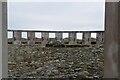
The summit of this hill in the townland of Keel East has several features that look like they could be cist burials. There are prostrate slabs and others laying upright along their edges. Some of these uprights lie parallel with or perpendicular to other slabs. Unfortunately I could not find any archaeological information about this location and therefore I can't say for sure if these are cists.
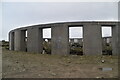
There is another stone structure at the summit. It is roughly circular with some stone walling intact. My guess is that this is the remains of a booley hut.
You may be viewing yesterday's version of this page. To see the most up to date information please register for a free account.
")
")
")
Do not use the above information on other web sites or publications without permission of the contributor.
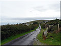
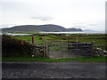
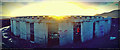
Nearby Images from Geograph Britain and Ireland:
©2016(licence)
©2016(licence)
©2014(licence)
©2022(licence)
©2022(licence)
The above images may not be of the site on this page, they are loaded from Geograph.
Please Submit an Image of this site or go out and take one for us!
Click here to see more info for this site
Nearby sites
Click here to view sites on an interactive map of the areaKey: Red: member's photo, Blue: 3rd party photo, Yellow: other image, Green: no photo - please go there and take one, Grey: site destroyed
Download sites to:
KML (Google Earth)
GPX (GPS waypoints)
CSV (Garmin/Navman)
CSV (Excel)
To unlock full downloads you need to sign up as a Contributory Member. Otherwise downloads are limited to 50 sites.
Turn off the page maps and other distractions
Nearby sites listing. In the following links * = Image available
32m NNW 340° Keel East standing stone* Standing Stone (Menhir) (F62640616)
93m WSW 252° Achill-henge* Modern Stone Circle etc
1.5km NE 47° Slievermore well Holy Well or Sacred Spring
2.6km NE 51° Stone Structures on Slievemore Mountain Ancient Village or Settlement
2.6km NE 55° Cromlech Tumulus* Ancient Village or Settlement (F64840756)
2.7km ENE 56° Keel East court tomb* Court Tomb (F64980758)
4.7km E 98° Loughannascaddy crannog* Crannog (F67330534)
12.1km N 3° Derible's Twist* Modern Stone Circle etc
12.1km N 2° Tobar Dherbhile (Fallmore) Early Christian Sculptured Stone (F635182)
12.2km ESE 120° Kildavnet Churchyard Crosses Ancient Cross (L731997)
17.7km NNW 337° Inishkea Cross Slab* Ancient Cross
29.9km S 173° Tobar Muire Holy Well or Sacred Spring
30.4km S 171° Teampaill Phádraig Early Christian Sculptured Stone
30.4km S 172° Caher stones Standing Stones
30.5km S 171° Caher forts Promontory Fort / Cliff Castle
30.6km S 180° Inishturk Stone II Standing Stone (Menhir)
31.0km S 181° Inishturk Stone Standing Stone (Menhir)
32.3km S 182° Dun Baile Greagaigh Promontory Fort / Cliff Castle
32.3km SSE 149° Formoyle Tomb Burial Chamber or Dolmen
32.4km S 182° Dun Baile Thiar Promontory Fort / Cliff Castle
32.5km S 182° Inishturk Fort Promontory Fort / Cliff Castle
32.5km SSE 157° Cloonlaur* Standing Stones (L744758)
33.2km SSE 158° Cross Lough Crannog Crannog
33.4km SSE 148° Knockeen Tomb Burial Chamber or Dolmen
33.7km SSE 157° Killadoon (2)* Standing Stone (Menhir)
View more nearby sites and additional images


 We would like to know more about this location. Please feel free to add a brief description and any relevant information in your own language.
 Wir möchten mehr über diese Stätte erfahren. Bitte zögern Sie nicht, eine kurze Beschreibung und relevante Informationen in Deutsch hinzuzufügen.
 Nous aimerions en savoir encore un peu sur les lieux. S'il vous plaît n'hesitez pas à ajouter une courte description et tous les renseignements pertinents dans votre propre langue.
 Quisieramos informarnos un poco más de las lugares. No dude en añadir una breve descripción y otros datos relevantes en su propio idioma.