 with our Megalithic Portal iPhone app")

<< Our Photo Pages >> Burton Moor - Ancient Village or Settlement in England in Yorkshire (North)
Submitted by rich32 on Wednesday, 28 September 2005 Page Views: 8700
Multi-periodSite Name: Burton MoorCountry: England County: Yorkshire (North) Type: Ancient Village or Settlement
Nearest Town: Richmond Nearest Village: West Burton
Map Ref: SE03118604
Latitude: 54.270006N Longitude: 1.953748W
Condition:
| 5 | Perfect |
| 4 | Almost Perfect |
| 3 | Reasonable but with some damage |
| 2 | Ruined but still recognisable as an ancient site |
| 1 | Pretty much destroyed, possibly visible as crop marks |
| 0 | No data. |
| -1 | Completely destroyed |
| 5 | Superb |
| 4 | Good |
| 3 | Ordinary |
| 2 | Not Good |
| 1 | Awful |
| 0 | No data. |
| 5 | Can be driven to, probably with disabled access |
| 4 | Short walk on a footpath |
| 3 | Requiring a bit more of a walk |
| 2 | A long walk |
| 1 | In the middle of nowhere, a nightmare to find |
| 0 | No data. |
| 5 | co-ordinates taken by GPS or official recorded co-ordinates |
| 4 | co-ordinates scaled from a detailed map |
| 3 | co-ordinates scaled from a bad map |
| 2 | co-ordinates of the nearest village |
| 1 | co-ordinates of the nearest town |
| 0 | no data |
Internal Links:
External Links:
")
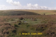
This settlement sits on the west side of Penhill, overlooking the dales villages of Aysgarth & West Burton.
Not an awful lot appears to be written about it, yet it is a truly magnificent site. Robert White, who is the Senior Conservation Archaeologist of the Yorkshire Dales National Park Authority, refers to it as being, “may be Bronze Age in date” in his book, “The Yorkshire Dales A Landscape Through Time”.
The settlement seems to consist of 2 parts, a habited area to the east & a larger area containing field systems to the west. The habited area has about 14 relatively small curvilinear enclosures all grouped together forming a nucleated pattern. Within these small enclosures & incorporated into the walling are numerous small circular features, thought to be hut circles. The size of these hut circles varies from 4 to 11 metres in diameter. Robert White quotes 14 such structures in his book, but using aerial photographs & site visits, I counted 26.
250 meters NW of the settlement, are the much larger enclosures of the field systems, the most distinct measuring 50 x 40 meters. Around this area a number of enclosures & a large amount of walling that has been missed, as far as official mapping is concerned. The OS map has the field system covering 350 meters, but on the ground you can track walling running nearly 1km N to S.
The 1856 OS map shows a further ancient settlement about 500 meters south of the habited area, but interestingly this settlement doesn’t appear on modern maps. The previously unmapped walling of the field systems run in the vicinity of the settlement noted in 1856. Therefore, it could be that the whole area was just one big settlement in antiquity.
Having said all this, there are some parts that sit uncomfortably in the Bronze Age, especially a small rectangular structure & a number of ruinous walls that look to be comprised of squared almost modern looking quarried stones.
You may be viewing yesterday's version of this page. To see the most up to date information please register for a free account.
")
")
")
")
")
")
Do not use the above information on other web sites or publications without permission of the contributor.
Click here to see more info for this site
Nearby sites
Key: Red: member's photo, Blue: 3rd party photo, Yellow: other image, Green: no photo - please go there and take one, Grey: site destroyed
Download sites to:
KML (Google Earth)
GPX (GPS waypoints)
CSV (Garmin/Navman)
CSV (Excel)
To unlock full downloads you need to sign up as a Contributory Member. Otherwise downloads are limited to 50 sites.
Turn off the page maps and other distractions
Nearby sites listing. In the following links * = Image available
4.4km NW 326° Carperby Cross* Ancient Cross (SE0063189729)
4.4km NNW 327° St Matthew's Well (Carperby)* Holy Well or Sacred Spring (SE0065689756)
5.0km WNW 284° Castle Dykes* Henge (SD9823187289)
5.8km NW 315° Carperby Stone Circle* Stone Circle (SD99009013)
6.6km WNW 283° Dove Stones (Thornton Rust Moor) Rock Art (SD9663487493)
7.0km ENE 60° Holy Trinity (Wensley)* Ancient Cross (SE09228954)
8.1km W 276° Stoney Raise* Cairn (SD95068691)
8.5km WNW 283° Addlebrough Cup-Marked Rock Rock Art (SD948879)
8.7km WNW 284° Addlebrough* Cairn (SD94598812)
8.9km WNW 283° Devil's Stone (Bainbridge) Natural Stone / Erratic / Other Natural Feature (SD94358799)
9.4km ENE 79° St Alkelda's Holy Well* Holy Well or Sacred Spring (SE124879)
9.7km WNW 301° Askrigg Cross* Ancient Cross (SD9480591026)
9.7km E 79° St Mary and St Alkelda* Ancient Cross (SE1262887878)
10.0km ENE 69° Fairy Well (Harmby)* Holy Well or Sacred Spring (SE12448969)
11.0km ESE 109° Agra Moor Standing Stone* Standing Stone (Menhir) (SE1349982440)
11.2km SSW 203° Little Hunters Sleets Cairn Cairn (SD98647576)
11.6km N 2° Harkerside Moor circle* Stone Circle (SE035976)
11.6km SSW 205° Tor Dike Ancient Village or Settlement (SD98137551)
11.8km ESE 112° West Agra Carving 1 Rock Art (SE1406981627)
11.8km ESE 112° West Agra Carving 2b Rock Art (SE1412681669)
11.9km ESE 111° West Agra* Rock Art (SE14248175)
11.9km ESE 112° West Agra 3a and 3b* Rock Art (SE1423681675)
12.1km N 356° Maiden Castle (N Yorks)* Ancient Village or Settlement (SE02189808)
12.1km N 356° Maiden Castle Barrow (Yorkshire North) Round Barrow(s) (SE02349814)
12.5km ESE 110° Gollinglith Foot (West Agra) Standing Stone (Menhir) (SE149817)
View more nearby sites and additional images


 We would like to know more about this location. Please feel free to add a brief description and any relevant information in your own language.
 Wir möchten mehr über diese Stätte erfahren. Bitte zögern Sie nicht, eine kurze Beschreibung und relevante Informationen in Deutsch hinzuzufügen.
 Nous aimerions en savoir encore un peu sur les lieux. S'il vous plaît n'hesitez pas à ajouter une courte description et tous les renseignements pertinents dans votre propre langue.
 Quisieramos informarnos un poco más de las lugares. No dude en añadir una breve descripción y otros datos relevantes en su propio idioma.