


<< Other Photo Pages >> Broad Well (Market Lavington) - Holy Well or Sacred Spring in England in Wiltshire
Submitted by vicky on Monday, 29 March 2004 Page Views: 12105
Springs and Holy WellsSite Name: Broad Well (Market Lavington) Alternative Name: Dipping WellCountry: England
NOTE: This site is 0.187 km away from the location you searched for.
County: Wiltshire Type: Holy Well or Sacred Spring
Nearest Town: Market Lavington
Map Ref: SU0159054026 Landranger Map Number: 184
Latitude: 51.285370N Longitude: 1.978585W
Condition:
| 5 | Perfect |
| 4 | Almost Perfect |
| 3 | Reasonable but with some damage |
| 2 | Ruined but still recognisable as an ancient site |
| 1 | Pretty much destroyed, possibly visible as crop marks |
| 0 | No data. |
| -1 | Completely destroyed |
| 5 | Superb |
| 4 | Good |
| 3 | Ordinary |
| 2 | Not Good |
| 1 | Awful |
| 0 | No data. |
| 5 | Can be driven to, probably with disabled access |
| 4 | Short walk on a footpath |
| 3 | Requiring a bit more of a walk |
| 2 | A long walk |
| 1 | In the middle of nowhere, a nightmare to find |
| 0 | No data. |
| 5 | co-ordinates taken by GPS or official recorded co-ordinates |
| 4 | co-ordinates scaled from a detailed map |
| 3 | co-ordinates scaled from a bad map |
| 2 | co-ordinates of the nearest village |
| 1 | co-ordinates of the nearest town |
| 0 | no data |
Internal Links:
External Links:
Holy Well / Spring in Wiltshire
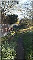
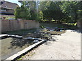
Although never a holy well, Broadwell was an important water source for Market Lavington up until the late 1950s, some 20 years after the town got a mains water supply. Along with the nearby Northbrook Well it was the main water supply for the village It is located in the heart of the village and is now a rather neglected wide pool next to a recreation ground. Quite sad really, but can be nice to visit during school hours when it is a little quieter!
You may be viewing yesterday's version of this page. To see the most up to date information please register for a free account.
Do not use the above information on other web sites or publications without permission of the contributor.
davidmorgan has found this location on Google Street View:
Nearby Images from Geograph Britain and Ireland:
![SU0154 : Market Lavington features [1] by Michael Dibb](https://s2.geograph.org.uk/geophotos/06/56/79/6567906_d43b5a2a_120x120.jpg)
©2020(licence)
©2018(licence)
![SU0154 : Market Lavington features [2] by Michael Dibb](https://s0.geograph.org.uk/geophotos/06/56/79/6567908_d9010879_120x120.jpg)
©2020(licence)
![SU0154 : Market Lavington features [6] by Michael Dibb](https://s1.geograph.org.uk/geophotos/06/79/70/6797057_c451f2c6_120x120.jpg)
©2021(licence)
©2020(licence)
The above images may not be of the site on this page, they are loaded from Geograph.
Please Submit an Image of this site or go out and take one for us!
Click here to see more info for this site
Nearby sites
Key: Red: member's photo, Blue: 3rd party photo, Yellow: other image, Green: no photo - please go there and take one, Grey: site destroyed
Download sites to:
KML (Google Earth)
GPX (GPS waypoints)
CSV (Garmin/Navman)
CSV (Excel)
To unlock full downloads you need to sign up as a Contributory Member. Otherwise downloads are limited to 50 sites.
Turn off the page maps and other distractions
Nearby sites listing. In the following links * = Image available
385m NNW 347° Northbrook Well Holy Well or Sacred Spring (SU015544)
476m NW 305° Boiley Pot Holy Well or Sacred Spring (SU012543)
4.1km NE 35° Jerusalem Well Holy Well or Sacred Spring (SU040574)
5.1km NNW 334° Whistley Lane Spout* Holy Well or Sacred Spring (ST9934158645)
5.4km NNW 337° Potterne Midden Ancient Village or Settlement (ST99505905)
6.3km SSW 194° Kill Barrow Long Barrow (SU0001547898)
6.5km S 175° Tilshead 5 Long Barrow (SU0211047523)
7.2km S 174° Tilshead Old Ditch* Long Barrow (SU02304683)
7.2km N 352° Wiltshire Heritage Museum* Museum (SU0055261196)
7.4km SSE 167° Tilshead White Barrow* Long Barrow (SU033468)
8.5km ENE 60° Marden Timber Circle Timber Circle (SU090583)
8.6km ENE 61° Marden Henge* Henge (SU09085820)
9.2km W 264° Ladywell (Edington) Holy Well or Sacred Spring (ST924530)
9.5km WSW 257° Luccombe Springs Holy Well or Sacred Spring (ST923519)
9.9km E 93° Casterley Camp* Hillfort (SU115535)
10.0km W 259° Cat's Well* Holy Well or Sacred Spring (ST91745220)
10.1km N 0° Devizes White Horse* Hill Figure or Geoglyph (SU01596414)
10.3km N 351° Mother Anthony's Well* Holy Well or Sacred Spring (ST9994664221)
10.3km SW 225° Boles Barrow* Long Barrow (ST9420346771)
10.4km NNE 33° All Cannings* Modern Stone Circle etc (SU07326275)
10.5km WSW 258° Church Springs Holy Well or Sacred Spring (ST913519)
10.5km NE 52° The Hanging Stone (Wiltshire)* Standing Stone (Menhir) (SU099605)
10.8km N 352° Oliver's Castle* Hillfort (SU00106468)
10.9km ENE 69° Cat's Brain* Long Barrow (SU1185057889)
11.2km NE 42° All Saints Church Stone* Standing Stone (Menhir) (SU0908262340)
View more nearby sites and additional images


 We would like to know more about this location. Please feel free to add a brief description and any relevant information in your own language.
 Wir möchten mehr über diese Stätte erfahren. Bitte zögern Sie nicht, eine kurze Beschreibung und relevante Informationen in Deutsch hinzuzufügen.
 Nous aimerions en savoir encore un peu sur les lieux. S'il vous plaît n'hesitez pas à ajouter une courte description et tous les renseignements pertinents dans votre propre langue.
 Quisieramos informarnos un poco más de las lugares. No dude en añadir una breve descripción y otros datos relevantes en su propio idioma.