


<< Our Photo Pages >> Roel Camp - Hillfort in England in Gloucestershire
Submitted by 4clydesdale7 on Thursday, 01 September 2011 Page Views: 8873
Iron Age and Later PrehistorySite Name: Roel Camp Alternative Name: Roel Gate Camp, Charlton Abbots CampCountry: England County: Gloucestershire Type: Hillfort
Nearest Town: Winchcombe Nearest Village: Charlton Abbots
Map Ref: SP04682434
Latitude: 51.917568N Longitude: 1.933363W
Condition:
| 5 | Perfect |
| 4 | Almost Perfect |
| 3 | Reasonable but with some damage |
| 2 | Ruined but still recognisable as an ancient site |
| 1 | Pretty much destroyed, possibly visible as crop marks |
| 0 | No data. |
| -1 | Completely destroyed |
| 5 | Superb |
| 4 | Good |
| 3 | Ordinary |
| 2 | Not Good |
| 1 | Awful |
| 0 | No data. |
| 5 | Can be driven to, probably with disabled access |
| 4 | Short walk on a footpath |
| 3 | Requiring a bit more of a walk |
| 2 | A long walk |
| 1 | In the middle of nowhere, a nightmare to find |
| 0 | No data. |
| 5 | co-ordinates taken by GPS or official recorded co-ordinates |
| 4 | co-ordinates scaled from a detailed map |
| 3 | co-ordinates scaled from a bad map |
| 2 | co-ordinates of the nearest village |
| 1 | co-ordinates of the nearest town |
| 0 | no data |
Internal Links:
External Links:
I have visited· I would like to visit
SumDoood would like to visit
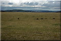
4clydesdale7 visited on 31st Aug 2011 - their rating: Cond: 2 Amb: 4 Access: 5 There is a lot more to be learned about Roel - field walking to the E (although over pasture) should reveal a large flint scatter
h_fenton have visited here
")
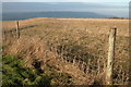
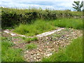
There is a substantial flint scatter between the site of the Camp and that of the Village. The design of the Camp is said to be of the type 'Phase 1', viz a single bank and ditch although recently 'geophys' has suggested that there is an internal ditch. There are 2 small medieval quarries within the Camp which encloses approx. 2.5 acres
The Camp stands very close to an extremely ancient track called 'The Saltway' or 'Campden Track', which is almost as straight as the much later Roman roads.
As it is so easy to get to it is well worth a visit - you can see Beckbury Camp to the NNE.
Witts Ancient Camp No 23 (Charlton Abbots);
Pastscape 327968
You may be viewing yesterday's version of this page. To see the most up to date information please register for a free account.
")
")
")
")
Do not use the above information on other web sites or publications without permission of the contributor.
Nearby Images from Geograph Britain and Ireland:
©2010(licence)
![SP0424 : Roel Camp [1] by Michael Dibb](https://s1.geograph.org.uk/geophotos/03/08/14/3081481_9d2392b4_120x120.jpg)
©2012(licence)
©2005(licence)
©2012(licence)
![SP0424 : Roel Camp [2] by Michael Dibb](https://s1.geograph.org.uk/geophotos/03/08/14/3081489_9842629b_120x120.jpg)
©2012(licence)
The above images may not be of the site on this page, they are loaded from Geograph.
Please Submit an Image of this site or go out and take one for us!
Click here to see more info for this site
Nearby sites
Key: Red: member's photo, Blue: 3rd party photo, Yellow: other image, Green: no photo - please go there and take one, Grey: site destroyed
Download sites to:
KML (Google Earth)
GPX (GPS waypoints)
CSV (Garmin/Navman)
CSV (Excel)
To unlock full downloads you need to sign up as a Contributory Member. Otherwise downloads are limited to 50 sites.
Turn off the page maps and other distractions
Nearby sites listing. In the following links * = Image available
2.7km E 95° Roel Farm Bowl Barrow* Round Barrow(s) (SP0740324085)
2.8km WNW 293° Belas Knap* Long Barrow (SP02092545)
3.3km NE 48° Guiting Wood Bowl Barrow* Round Barrow(s) (SP0710826545)
3.3km SE 138° Slade Barn Chambered Cairn (SP069219)
3.5km N 355° St. Kenelm's Well* Holy Well or Sacred Spring (SP0435827795)
3.8km E 88° Greenfield Hill Barn Round Barrow* Round Barrow(s) (SP0844224465)
4.4km NNE 21° Farmcote gatepost* Standing Stone (Menhir) (SP0624828468)
4.9km E 88° Guiting Power Round Barrow 3* Timber Circle (SP096245)
5.2km SSE 157° Penhill Farm Bowl Barrow* Round Barrow(s) (SP06761954)
5.8km NNE 17° Beckbury Camp* Hillfort (SP06392988)
5.8km ESE 123° Notgrove* Long Barrow (SP096212)
5.8km N 10° Hailes Wood Earthworks Misc. Earthwork (SP05663009)
6.0km SSE 154° Hazleton North* Chambered Tomb (SP073189)
6.1km SSE 156° Hazleton South* Chambered Tomb (SP072188)
6.3km NNE 23° Campden Lane gatepost* Marker Stone (SP07153009)
6.3km W 280° Cleeve Hill (Gloucestershire)* Hillfort (SO98492546)
6.3km W 261° Prestbury (Glos) Chambered Tomb (SO984233)
6.4km WNW 287° Cleeve Hill Cross Dyke* Misc. Earthwork (SO98562625)
6.6km WNW 290° The Ring (Gloucestershire)* Ancient Village or Settlement (SO98472659)
6.7km NNE 24° Stanway Bowl Barrows* Round Barrow(s) (SP07413044)
6.7km WNW 300° Cleeve Hill Barrows Round Barrow(s) (SO98872767)
7.1km SW 223° North Dowdeswell* Hillfort (SO99851910)
7.1km NW 304° Nottingham Hill Carving (Gotherington)* Rock Art (SO98752835)
7.2km SW 217° South Dowdeswell Hillfort (SP0040018600)
7.5km WNW 303° Nottingham Hill* Hillfort (SO984284)
View more nearby sites and additional images


 We would like to know more about this location. Please feel free to add a brief description and any relevant information in your own language.
 Wir möchten mehr über diese Stätte erfahren. Bitte zögern Sie nicht, eine kurze Beschreibung und relevante Informationen in Deutsch hinzuzufügen.
 Nous aimerions en savoir encore un peu sur les lieux. S'il vous plaît n'hesitez pas à ajouter une courte description et tous les renseignements pertinents dans votre propre langue.
 Quisieramos informarnos un poco más de las lugares. No dude en añadir una breve descripción y otros datos relevantes en su propio idioma.