


<< Our Photo Pages >> Menhir de Bel Air (Pipriac) - Standing Stone (Menhir) in France in Bretagne:Ille-et-Vilaine (35)
Submitted by aolson on Sunday, 29 May 2016 Page Views: 1293
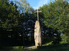
Multi-periodSite Name: Menhir de Bel Air (Pipriac)Country: France
NOTE: This site is 3.327 km away from the location you searched for.
Département: Bretagne:Ille-et-Vilaine (35) Type: Standing Stone (Menhir)
Nearest Town: Redon Nearest Village: Pipriac
Latitude: 47.821275N Longitude: 1.962476W
Condition:
| 5 | Perfect |
| 4 | Almost Perfect |
| 3 | Reasonable but with some damage |
| 2 | Ruined but still recognisable as an ancient site |
| 1 | Pretty much destroyed, possibly visible as crop marks |
| 0 | No data. |
| -1 | Completely destroyed |
| 5 | Superb |
| 4 | Good |
| 3 | Ordinary |
| 2 | Not Good |
| 1 | Awful |
| 0 | No data. |
| 5 | Can be driven to, probably with disabled access |
| 4 | Short walk on a footpath |
| 3 | Requiring a bit more of a walk |
| 2 | A long walk |
| 1 | In the middle of nowhere, a nightmare to find |
| 0 | No data. |
| 5 | co-ordinates taken by GPS or official recorded co-ordinates |
| 4 | co-ordinates scaled from a detailed map |
| 3 | co-ordinates scaled from a bad map |
| 2 | co-ordinates of the nearest village |
| 1 | co-ordinates of the nearest town |
| 0 | no data |
Internal Links:
External Links:
I have visited· I would like to visit
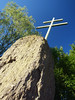
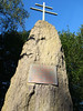
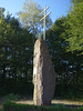
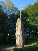
aolson visited on 19th Jul 2020 - their rating: Cond: 3 Amb: 3 Access: 5 One last site to finish the day. Bel Air certainly donated quite a few menhirs to the neighboring towns.
 (PID:214139)")
Pipriac, Redon, Ille-et-Vilaine, Brittany
Source: T4T35
Information and Pictures:
www.t4t35.fr
Page originally by Holger Rix
You may be viewing yesterday's version of this page. To see the most up to date information please register for a free account.
Do not use the above information on other web sites or publications without permission of the contributor.
Nearby Images from Flickr

The above images may not be of the site on this page, but were taken nearby. They are loaded from Flickr so please click on them for image credits.
Click here to see more info for this site
Nearby sites
Click here to view sites on an interactive map of the areaKey: Red: member's photo, Blue: 3rd party photo, Yellow: other image, Green: no photo - please go there and take one, Grey: site destroyed
Download sites to:
KML (Google Earth)
GPX (GPS waypoints)
CSV (Garmin/Navman)
CSV (Excel)
To unlock full downloads you need to sign up as a Contributory Member. Otherwise downloads are limited to 50 sites.
Turn off the page maps and other distractions
Nearby sites listing. In the following links * = Image available
4.6km S 183° Menhirs des Pierres Chevêches 1 Standing Stones
4.8km S 183° Menhirs des Pierres Chevêches 2 Standing Stones
5.2km SSW 200° Alignement de la Forgerais Stone Row / Alignment
6.0km S 179° Cimetière St. Just* Stone Row / Alignment
6.0km SSW 212° Grotte-aux-Fées (Tréal)* Burial Chamber or Dolmen
6.2km S 169° Alignement dit le Rocher* Stone Row / Alignment
6.3km S 187° Alignements du Moulin N* Stone Row / Alignment
6.3km S 188° Alignements du Moulin S* Stone Row / Alignment
6.3km S 184° Croix Madame* Barrow Cemetery
6.4km S 189° Alignements du Moulin W* Stone Row / Alignment
6.4km S 189° Alignement des Petites Roches Piquées* Stone Row / Alignment
6.5km SSW 195° Château Bû* Chambered Cairn
6.5km SSW 194° Demoiselles Piquées* Stone Row / Alignment
6.5km SSW 198° Ciste de Croix Saint-Pierre* Cist
6.5km SSW 197° Croix St Pierre east* Chambered Cairn
6.5km SSW 197° Croix St Pierre tertre* Long Barrow
6.5km SSW 199° Cupules de la Grée de Cojoux Rock Art
6.5km SSW 198° Dolmen Ouest de la Croix de Saint-Pierre* Burial Chamber or Dolmen
6.5km SSW 199° Tombe nord-ouest de Croix St Pierre Burial Chamber or Dolmen
6.6km SSE 167° Sévéroué menhir* Standing Stone (Menhir)
6.6km SSW 198° Le Tribunal* Stone Circle
6.6km SSE 158° Alignement d'Allérac Stone Row / Alignment
6.6km SSW 200° Le Four Sarrazin* Burial Chamber or Dolmen
6.6km SSW 201° Monument du Four Sarrazin Ouest Burial Chamber or Dolmen
6.7km S 175° Menhir des Landes de Gremel* Modern Stone Circle etc
View more nearby sites and additional images


 We would like to know more about this location. Please feel free to add a brief description and any relevant information in your own language.
 Wir möchten mehr über diese Stätte erfahren. Bitte zögern Sie nicht, eine kurze Beschreibung und relevante Informationen in Deutsch hinzuzufügen.
 Nous aimerions en savoir encore un peu sur les lieux. S'il vous plaît n'hesitez pas à ajouter une courte description et tous les renseignements pertinents dans votre propre langue.
 Quisieramos informarnos un poco más de las lugares. No dude en añadir una breve descripción y otros datos relevantes en su propio idioma.