


<< Our Photo Pages >> Watery Hey Well - Holy Well or Sacred Spring in England in Derbyshire
Submitted by Boggart on Tuesday, 26 March 2013 Page Views: 5034
Springs and Holy WellsSite Name: Watery Hey Well Alternative Name: Watery EyeCountry: England
NOTE: This site is 2.694 km away from the location you searched for.
County: Derbyshire Type: Holy Well or Sacred Spring
Nearest Village: Hayfield
Map Ref: SK0399986733
Latitude: 53.377437N Longitude: 1.941352W
Condition:
| 5 | Perfect |
| 4 | Almost Perfect |
| 3 | Reasonable but with some damage |
| 2 | Ruined but still recognisable as an ancient site |
| 1 | Pretty much destroyed, possibly visible as crop marks |
| 0 | No data. |
| -1 | Completely destroyed |
| 5 | Superb |
| 4 | Good |
| 3 | Ordinary |
| 2 | Not Good |
| 1 | Awful |
| 0 | No data. |
| 5 | Can be driven to, probably with disabled access |
| 4 | Short walk on a footpath |
| 3 | Requiring a bit more of a walk |
| 2 | A long walk |
| 1 | In the middle of nowhere, a nightmare to find |
| 0 | No data. |
| 5 | co-ordinates taken by GPS or official recorded co-ordinates |
| 4 | co-ordinates scaled from a detailed map |
| 3 | co-ordinates scaled from a bad map |
| 2 | co-ordinates of the nearest village |
| 1 | co-ordinates of the nearest town |
| 0 | no data |
Internal Links:
External Links:
")
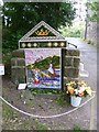
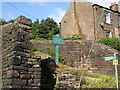
The well is surrounded by a large structure with two small steps that lead to a large, deep pool of clear spring water.
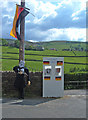
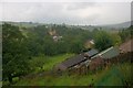
To get to the well go through Hayfield village up the hill to the antique shop at Top O'the Town and turn left onto Valley Road. Follow this to the end of a row of terraced cottages and turn left down a short, steep path that leads to the children's playground. The well is on the right at the bottom of the path close to the river Sett.
This well is one of a few in the village that is decorated every July for the annual Well Dressing ceremony.
You may be viewing yesterday's version of this page. To see the most up to date information please register for a free account.
")
")
Do not use the above information on other web sites or publications without permission of the contributor.
davidmorgan has found this location on Google Street View:
Nearby Images from Geograph Britain and Ireland:
©2011(licence)
©2007(licence)
©2012(licence)
©2019(licence)
©2019(licence)
The above images may not be of the site on this page, they are loaded from Geograph.
Please Submit an Image of this site or go out and take one for us!
Click here to see more info for this site
Nearby sites
Key: Red: member's photo, Blue: 3rd party photo, Yellow: other image, Green: no photo - please go there and take one, Grey: site destroyed
Download sites to:
KML (Google Earth)
GPX (GPS waypoints)
CSV (Garmin/Navman)
CSV (Excel)
To unlock full downloads you need to sign up as a Contributory Member. Otherwise downloads are limited to 50 sites.
Turn off the page maps and other distractions
Nearby sites listing. In the following links * = Image available
379m E 96° Whitworth Well* Holy Well or Sacred Spring (SK0437786691)
1.4km ESE 110° White Lady standing stone* Standing Stone (Menhir) (SK0534286250)
1.5km ENE 72° Upper Dole Field Well* Holy Well or Sacred Spring (SK054872)
1.5km E 87° Tunstead Clough* Ancient Village or Settlement (SK055868)
1.7km ESE 115° Fog Field Well* Holy Well or Sacred Spring (SK05578602)
1.8km ESE 122° Coldwell Clough Anglo Saxon cross Ancient Cross (SK055858)
2.2km SE 134° Mount Famine burial cist* Cist (SK056852)
3.2km S 189° Chinley Churn Barrow Round Barrow(s) (SK035836)
3.3km E 91° Kinderlow Bowl Barrow* Round Barrow(s) (SK073867)
3.8km E 100° Edale Cross* Ancient Cross (SK0772586092)
3.9km ENE 79° Cluther Rocks* Ancient Mine, Quarry or other Industry (SK078875)
3.9km ENE 60° Mermaid's Pool* Holy Well or Sacred Spring (SK074887)
3.9km NE 43° Cairn on Kinder Scout Cairn (SK067896)
4.1km NE 41° Kinder Scout II Round Barrow(s) (SK06728981)
4.2km NE 35° Kinder Scout I Round Barrow(s) (SK06439014)
4.4km NW 310° Ringstones (Derbyshire)* Stone Circle (SK006896)
4.8km NW 320° Ringstones (new circle at Near Slack Farm)* Modern Stone Circle etc (SK0087290394)
5.3km NW 322° Chisworth Cupmarked stone* Rock Art (SK007909)
5.3km W 276° Mellor Moor* Cairn (SJ9867187246)
5.4km NW 321° Robin Hood's Picking Rods* Ancient Cross (SK0060990941)
5.5km NNW 339° Coombes Edge* Ring Cairn (SK0204591892)
5.8km SE 130° Green Low ringcairn* Ring Cairn (SK084830)
6.1km S 174° Nanny Well* Holy Well or Sacred Spring (SK046807)
6.1km SSE 160° Nanny's Well (Chapel le Frith) Holy Well or Sacred Spring (SK061810)
6.2km SSE 164° St Thomas Becket (Chapel en le Frith)* Ancient Cross (SK0574580820)
View more nearby sites and additional images


 We would like to know more about this location. Please feel free to add a brief description and any relevant information in your own language.
 Wir möchten mehr über diese Stätte erfahren. Bitte zögern Sie nicht, eine kurze Beschreibung und relevante Informationen in Deutsch hinzuzufügen.
 Nous aimerions en savoir encore un peu sur les lieux. S'il vous plaît n'hesitez pas à ajouter une courte description et tous les renseignements pertinents dans votre propre langue.
 Quisieramos informarnos un poco más de las lugares. No dude en añadir una breve descripción y otros datos relevantes en su propio idioma.