 with our Megalithic Portal iPhone app")


<< Our Photo Pages >> Bury Hill Camp (Purton) - Hillfort in England in Wiltshire
Submitted by 4clydesdale7 on Thursday, 16 October 2014 Page Views: 4677
Iron Age and Later PrehistorySite Name: Bury Hill Camp (Purton)Country: England
NOTE: This site is 4.095 km away from the location you searched for.
County: Wiltshire Type: Hillfort
Nearest Town: Cricklade Nearest Village: Purton
Map Ref: SU05759010
Latitude: 51.609704N Longitude: 1.918361W
Condition:
| 5 | Perfect |
| 4 | Almost Perfect |
| 3 | Reasonable but with some damage |
| 2 | Ruined but still recognisable as an ancient site |
| 1 | Pretty much destroyed, possibly visible as crop marks |
| 0 | No data. |
| -1 | Completely destroyed |
| 5 | Superb |
| 4 | Good |
| 3 | Ordinary |
| 2 | Not Good |
| 1 | Awful |
| 0 | No data. |
| 5 | Can be driven to, probably with disabled access |
| 4 | Short walk on a footpath |
| 3 | Requiring a bit more of a walk |
| 2 | A long walk |
| 1 | In the middle of nowhere, a nightmare to find |
| 0 | No data. |
| 5 | co-ordinates taken by GPS or official recorded co-ordinates |
| 4 | co-ordinates scaled from a detailed map |
| 3 | co-ordinates scaled from a bad map |
| 2 | co-ordinates of the nearest village |
| 1 | co-ordinates of the nearest town |
| 0 | no data |
Internal Links:
External Links:
 (PID:126460)")
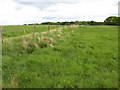
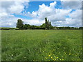
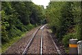
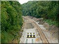
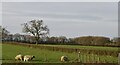
This late Bronze Age/early Iron Age Hillfort (referred to on some OS Maps as a Settlement) lies NW of the Village of Purton just 600m to the East of Bridge Farm (on the B4696) between Cox Hill and the Swindon to Stroud Railway - it is very carefully described as a 'Slight Univallate Hillfort' and is often overlooked because of the proximity of its near neighbour the more spectacular Ringsbury Camp to the SSE
Its area is some 2.6 ha (6 1/2 acres) and is divided by several modern hedges and fences - the Bank rarely rises above 1m and the Ditch (probably the more prominent feature) seldom descends below 1 1/2 m - there is an entrance to the NW and the Camp commands a beautiful view to the Vale over the railway to the south and east - interestingly the approaches either from Bridge Farm (to the west) or Purton Stoke (to the east) take the visitor along an old Drovers Road
A leisurely stroll for a summer's afternoon, the camp is well worth a visit -
Pastscape monument no. 216720.
You may be viewing yesterday's version of this page. To see the most up to date information please register for a free account.
 (PID:126462)")
 (PID:126461)")
Do not use the above information on other web sites or publications without permission of the contributor.
Nearby Images from Geograph Britain and Ireland:
©2020(licence)
©2020(licence)
©2009(licence)
©2013(licence)
©2020(licence)
The above images may not be of the site on this page, they are loaded from Geograph.
Please Submit an Image of this site or go out and take one for us!
Click here to see more info for this site
Nearby sites
Key: Red: member's photo, Blue: 3rd party photo, Yellow: other image, Green: no photo - please go there and take one, Grey: site destroyed
Download sites to:
KML (Google Earth)
GPX (GPS waypoints)
CSV (Garmin/Navman)
CSV (Excel)
To unlock full downloads you need to sign up as a Contributory Member. Otherwise downloads are limited to 50 sites.
Turn off the page maps and other distractions
Nearby sites listing. In the following links * = Image available
2.7km E 79° Salt's Hole* Holy Well or Sacred Spring (SU084906)
3.8km SSE 153° Ringsbury Camp* Hillfort (SU07488676)
10.0km E 84° Castle Hillfort* Hillfort (SU15689118)
10.8km NW 321° Lyd Well (Kemble) Holy Well or Sacred Spring (ST98969847)
10.9km S 189° Tockenham Spring* Holy Well or Sacred Spring (SU040793)
11.3km NNE 17° Ranbury Ring* Hillfort (SP090009)
11.4km NW 321° King Athelstans Mounting Stone* Marker Stone (ST98549899)
11.9km SSE 155° Bincknoll Castle* Hillfort (SU10747933)
12.0km NNW 342° Querns Barrow* Chambered Tomb (SP01980150)
12.3km NW 322° Trewsbury Camp* Hillfort (ST98109980)
12.5km NNW 343° Corinium Museum* Museum (SP0212602059)
12.6km NW 305° Haresdown Barrow* Round Barrow(s) (ST95489737)
12.7km NNW 348° Tar Barrow* Round Barrow(s) (SP03110252)
13.0km WSW 257° Daniel's Well* Holy Well or Sacred Spring (ST931871)
13.3km SE 125° Broome Circle Stone Circle (SU16748251)
13.5km SE 129° Fir Clump, Burderop Wood Stone Circle (SU16298164)
14.4km WNW 300° Windmill Tump* Long Barrow (ST93259731)
14.6km ESE 122° Coate circle* Stone Circle (SU18168239)
14.8km WNW 300° Hasleden Barrow* Round Barrow(s) (ST92949760)
15.0km NNW 337° Wellhill Copse Barrow* Round Barrow(s) (SO99740387)
15.0km SSE 166° Winterbourne Bassett* Stone Circle (SU094755)
15.6km SSE 158° Fiddler's Hill (Wiltshire)* Standing Stone (Menhir) (SU117757)
15.9km WNW 291° Warren Tump (Gloucestershire)* Round Barrow(s) (ST90889577)
16.0km NW 319° Cassey Well* Holy Well or Sacred Spring (SO952022)
16.0km WNW 284° Worswell* Holy Well or Sacred Spring (ST90149395)
View more nearby sites and additional images


 We would like to know more about this location. Please feel free to add a brief description and any relevant information in your own language.
 Wir möchten mehr über diese Stätte erfahren. Bitte zögern Sie nicht, eine kurze Beschreibung und relevante Informationen in Deutsch hinzuzufügen.
 Nous aimerions en savoir encore un peu sur les lieux. S'il vous plaît n'hesitez pas à ajouter une courte description et tous les renseignements pertinents dans votre propre langue.
 Quisieramos informarnos un poco más de las lugares. No dude en añadir una breve descripción y otros datos relevantes en su propio idioma.