


<< Our Photo Pages >> St George's Well (Minsteracres) - Holy Well or Sacred Spring in England in Northumberland
Submitted by Anne T on Tuesday, 07 May 2019 Page Views: 1337
Springs and Holy WellsSite Name: St George's Well (Minsteracres)Country: England
NOTE: This site is 4.717 km away from the location you searched for.
County: Northumberland Type: Holy Well or Sacred Spring
Nearest Town: Hexham Nearest Village: Riding Mill / Scales Cross
Map Ref: NZ0274555884
Latitude: 54.897680N Longitude: 1.958727W
Condition:
| 5 | Perfect |
| 4 | Almost Perfect |
| 3 | Reasonable but with some damage |
| 2 | Ruined but still recognisable as an ancient site |
| 1 | Pretty much destroyed, possibly visible as crop marks |
| 0 | No data. |
| -1 | Completely destroyed |
| 5 | Superb |
| 4 | Good |
| 3 | Ordinary |
| 2 | Not Good |
| 1 | Awful |
| 0 | No data. |
| 5 | Can be driven to, probably with disabled access |
| 4 | Short walk on a footpath |
| 3 | Requiring a bit more of a walk |
| 2 | A long walk |
| 1 | In the middle of nowhere, a nightmare to find |
| 0 | No data. |
| 5 | co-ordinates taken by GPS or official recorded co-ordinates |
| 4 | co-ordinates scaled from a detailed map |
| 3 | co-ordinates scaled from a bad map |
| 2 | co-ordinates of the nearest village |
| 1 | co-ordinates of the nearest town |
| 0 | no data |
Internal Links:
External Links:
I have visited· I would like to visit
Anne T visited on 6th May 2019 - their rating: Cond: 3 Amb: 4 Access: 4 St George's Well, Minsteracres: Minsteracres had an open day today between 11am and 4pm, so we decided to drive up and see if we could find the well. I understood that it was located near to the chapel, but this was mistaken, as we found out on arrival.
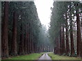
Driving up the private road from the A68, we parked just past the cattle grid about 200m away from the main buildings, parked on the grass alongside the vegetable garden to our north, and walked back to The Shrubbery, a woodland with specimen and ornamental trees and two signposted walks.
With only a rough grid reference to guide us, but with the OS map in hand, it quickly became apparent that the well wasn’t in The Shrubbery, so we made our way back to the road and walked a little back towards the A68, heading north-north-east. In a small wood to our right hand side, the well became quickly apparent. I quickly recorded the waypoint on our GPS.
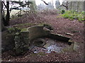
Whilst there was water in the pool, there was no water bubbling into the well pool. The well had a fairly large ditch running from it, so there appears to still be a fair flow of water from it at certain times.
Someone had recently been clearing away weeds and shrubs from the area. Scrapping away some of the leaves at the base of the steps into the well basin, water quickly flowed in to fill up the space where the leaves had been, although there was no evidence of flow.
 (PID:196983)")
There is not much information available about this well, which is listed as part of Pastscape Monument No. 958244. This briefly describes Minsteracres Park as "(a) park with gate lodges, water features, a well and a chapel".
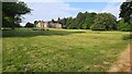
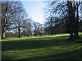
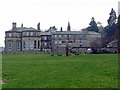
Minsteracres is a private estate of 110 acres, founded as a seminary to train Passionist priests, but since the 1960s opened to the public as a Passionist Retreat Centre for people of all faiths. Minsteracres holds regular Open Days for the public - visit their website at Minsteracres Retreat Centre.
The well is located to the north east of the main buildings, in a small wood to the north of The Shrubbery (a gated area with set walks through an arboretum). An easy walk, the well will be on your right hand side as you head north towards the lodge house at Scales Cross from the small parking area to the south of the cattle grid near the formal vegetable garden (note: there is a long, single track private road leading to the Minsteracres main buildings, with few passing places). The well is about 20m or less from the road on your eastern side; volunteers have recently cleared the area around the well of all excess shrubbery.
At the time of our visit, there was water within the well basin, but no water bubbling up or flowing down the channel to its northern side. A few shallow steps lead down into a larger well pool, which is paved.
Note: whilst the well is outside the fenced off area with the main buildings, if visiting outside Open Days, I would recommend contacting the Retreat Centre for permission as it is a private estate. Parking near the well is available opposite the vegetable gardens at approx. NZ 02590 55823.
You may be viewing yesterday's version of this page. To see the most up to date information please register for a free account.
 (PID:196986)")
 (PID:196985)")
 (PID:196984)")
 (PID:196982)")
Do not use the above information on other web sites or publications without permission of the contributor.
Nearby Images from Geograph Britain and Ireland:
©2015(licence)
©2015(licence)
©2023(licence)
©2007(licence)
©2015(licence)
The above images may not be of the site on this page, they are loaded from Geograph.
Please Submit an Image of this site or go out and take one for us!
Click here to see more info for this site
Nearby sites
Key: Red: member's photo, Blue: 3rd party photo, Yellow: other image, Green: no photo - please go there and take one, Grey: site destroyed
Download sites to:
KML (Google Earth)
GPX (GPS waypoints)
CSV (Garmin/Navman)
CSV (Excel)
To unlock full downloads you need to sign up as a Contributory Member. Otherwise downloads are limited to 50 sites.
Turn off the page maps and other distractions
Nearby sites listing. In the following links * = Image available
3.5km NE 53° Castle Hill (Whittonstall)* Ancient Village or Settlement (NZ05585801)
5.9km NNE 21° St Peter's (Bywell)* Early Christian Sculptured Stone (NZ0492261422)
6.0km NNE 20° St Andrew's Church (Bywell)* Ancient Cross (NZ04836148)
6.0km NNE 21° Bywell Cross* Ancient Cross (NZ0489661513)
8.2km SW 228° St Mary the Virgin (Blanchland)* Ancient Cross (NY9659850408)
8.4km NNE 22° Entry Well (Ovington)* Holy Well or Sacred Spring (NZ0589163703)
8.9km N 355° Thornborough High Barns* Rock Art (NZ01896478)
9.0km NNE 28° St Andrew's Well (Ovington)* Holy Well or Sacred Spring (NZ0697563896)
9.3km NNW 338° Old Viney Museum (Corbridge)* Sculptured Stone (NY99226445)
9.4km NNW 336° Corbridge Crosses* Ancient Cross (NY9885564411)
9.4km NNW 335° St Andrew's Church (Corbridge)* Ancient Cross (NY98836443)
9.7km NE 36° Ovingham Cross* Ancient Cross (NZ08506370)
9.7km NNW 336° Old Prior Manor House Well (Corbridge)* Holy Well or Sacred Spring (NY9879164783)
9.9km NE 40° Prudhoe Castle* Rock Art (NZ09186342)
10.0km NNW 333° Corbridge Rock Art Panel* Rock Art (NY9826764830)
10.0km NNE 26° Hunters Hill (Ovington) Rock Art (NZ0711064900)
10.0km NNE 29° Eddybroth Well (Whittle Dene)* Holy Well or Sacred Spring (NZ0760464659)
10.1km NNW 333° Hadrian's Wall (Coria)* Stone Fort or Dun (NY9818064904)
10.2km ENE 57° North View enclosure* Ancient Village or Settlement (NZ114614)
10.3km NNW 349° Meg's Well, Aydon* Holy Well or Sacred Spring (NZ0070465949)
10.3km NW 321° Dilston cists* Cist (NY963639)
10.3km N 357° Bow Bridge Homestead* Ancient Village or Settlement (NZ02256615)
10.4km SW 217° Old Man's Grave (Edmunbyers)* Marker Stone (NY96464763)
10.4km ENE 73° Ceoppa's Barrow* Round Barrow(s) (NZ1270258908)
11.1km SE 130° The Knitsley Stone Rock Art (NZ1120048700)
View more nearby sites and additional images


 We would like to know more about this location. Please feel free to add a brief description and any relevant information in your own language.
 Wir möchten mehr über diese Stätte erfahren. Bitte zögern Sie nicht, eine kurze Beschreibung und relevante Informationen in Deutsch hinzuzufügen.
 Nous aimerions en savoir encore un peu sur les lieux. S'il vous plaît n'hesitez pas à ajouter une courte description et tous les renseignements pertinents dans votre propre langue.
 Quisieramos informarnos un poco más de las lugares. No dude en añadir una breve descripción y otros datos relevantes en su propio idioma.