


<< Our Photo Pages >> Percy's Leap (Beanley) - Natural Stone / Erratic / Other Natural Feature in England in Northumberland
Submitted by Anne T on Wednesday, 26 September 2018 Page Views: 1826
Natural PlacesSite Name: Percy's Leap (Beanley)Country: England County: Northumberland Type: Natural Stone / Erratic / Other Natural Feature
Nearest Town: Alnwick / Wooler Nearest Village: Eglingham / Powburn
Map Ref: NU0496819802
Latitude: 55.472022N Longitude: 1.922968W
Condition:
| 5 | Perfect |
| 4 | Almost Perfect |
| 3 | Reasonable but with some damage |
| 2 | Ruined but still recognisable as an ancient site |
| 1 | Pretty much destroyed, possibly visible as crop marks |
| 0 | No data. |
| -1 | Completely destroyed |
| 5 | Superb |
| 4 | Good |
| 3 | Ordinary |
| 2 | Not Good |
| 1 | Awful |
| 0 | No data. |
| 5 | Can be driven to, probably with disabled access |
| 4 | Short walk on a footpath |
| 3 | Requiring a bit more of a walk |
| 2 | A long walk |
| 1 | In the middle of nowhere, a nightmare to find |
| 0 | No data. |
| 5 | co-ordinates taken by GPS or official recorded co-ordinates |
| 4 | co-ordinates scaled from a detailed map |
| 3 | co-ordinates scaled from a bad map |
| 2 | co-ordinates of the nearest village |
| 1 | co-ordinates of the nearest town |
| 0 | no data |
Internal Links:
External Links:
I have visited· I would like to visit
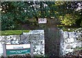
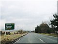
Anne T visited on 23rd Sep 2018 - their rating: Cond: 2 Amb: 2 Access: 5 Percy's Leap, Beanley (associated with Percy's Cross): Labelled ‘Percy’s Leap’ on the OS with a semi-circular enclosure marked against the edge of the road. Having the car pointed in this direction, and curious to see this site, as it sounded related to Percy’s Cross (by the name), we headed up and parked in the small layby by the information/interpretation board.
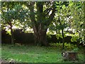
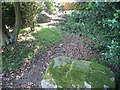
There is a low stone wall next to the layby and a gate leading into a semi-circular walled enclosure which is heavily littered and not pleasant. Inside the enclosure a two large stones, which look as if they have been dumped there for effect. In fact, these are two glacial erratics. There are two other interpretation boards inside the enclosure.
The first interpretation board inside the enclosure reads: “The Red Rose of Lancaster. For 30 years between 1455 and 1485 the two families of Lancaster and York fought for the Crown of England. Between 1461 and 1464 the North of England was the centre of activity in the Wars of the Roses. Edward IV supported by the Yorkists was on the throne which he had taken away from the weak Henry VI After the Lancastrian defeat in 1461 at Towton in Yorkshire Henry VI and his wife, Queen Margaret of Anjou, fled to Scotland to plan another campaign against Edward. / Sir Ralph Percy third son of the second Earl of Northumberland, changed sides four times in the Wars of the Roses. In Spring 1463 he was in the Lancastrian fold as were his castles at Bamburgh and Dunstanburgh. In 1464 Edward IV decided to seek a truce with Scotland to enable him to take action to crush the Lancastrians to the north. Lord Montague, younger brother of Warwick the Kingmaker, was sent to escort a Scottish mission through Northumberland in safety. / Learning of Lord Montague’s attempts to meet the Scottish mission the Lancastrians tried to ambush the Yorkists in Durham but this failed when Montague was alerted to the threat. Before proceeding further north Montague increased his forces at Newcastle. His path to Scotland was barred here at Hedgeley Moor by the Lancastrian troops of Sir Ralph Percy and the Lords Hungerford and Ros. / At the start of the battle Lords Hungerford and Ros decided to leave the field with their troops. Montague’s and Percy’s troops attacked head on. Sir Ralph Percy is reputed to have charged the Yorkist line at which his horse is said to have leapt and was wounded doing so. Sir Ralph fell soon afterwards and said at his death, “I have saved the bird in my bosom”. It is not known whether his final words meant that he died for his rightful monarch, Henry VI, or whether he had kept the secret of where Henry and Margaret were hiding. / Montague’s troops finished off the remaining Lancastrians quickly. Less than a month later the two armies met at Hexham where the Yorkists won a convincing victory which ended the Wars in the north for the time being. / Legend has it that the two stones in front of you mark the leap of Sir Ralph’s horse at the height of the battle.”
There is no record on HE for this site.
 (PID:185965)")
This site has a close association with Percy's Cross, some half a mile to the south. Marked on the OS Map, it is recorded as Pastscape Monument No. 4967, the first part of the entry reading: "Two glacial erratics, in a field known as Percy's Leap. The field name is presumed to be linked with the battle of Hedgeley Moor (1464)."
There is parking outside of Percy's Leap in a small layby, big enough perhaps for two cars. There are three information boards, one by the layby, the other two within the semi-circular stone walled area. One tells us: "Legend has it that the two stones in front of you mark the leap of Sir Ralph’s horse at the height of the (Hedgeley Moor) battle."
Placed just over nine yards apart, an early reference describes the two erratics as 'two ancient monoliths'. A later entry corrects this: "one stone is said to be 'in its natural position', the other placed there. There is no evidence of either stone being erected." The latter was said to be later placed to makr the distance the horse leapt - quite a distance!
For more information about the battle, see Britannia: Hedgeley Moor Battle. Again, whilst well explained, this area is horribly filled with litter, and not a pleasant place to be. However, looking over the western side of the enclosure wall gives a view onto what was part of the battlefield, and a field full of ripe corn at the time of our visit.
You may be viewing yesterday's version of this page. To see the most up to date information please register for a free account.
 (PID:185964)")
 (PID:185963)")
 (PID:185962)")
Do not use the above information on other web sites or publications without permission of the contributor.
Nearby Images from Geograph Britain and Ireland:
©2009(licence)
©2009(licence)
©2013(licence)
©2013(licence)
©2013(licence)
The above images may not be of the site on this page, they are loaded from Geograph.
Please Submit an Image of this site or go out and take one for us!
Click here to see more info for this site
Nearby sites
Key: Red: member's photo, Blue: 3rd party photo, Yellow: other image, Green: no photo - please go there and take one, Grey: site destroyed
Download sites to:
KML (Google Earth)
GPX (GPS waypoints)
CSV (Garmin/Navman)
CSV (Excel)
To unlock full downloads you need to sign up as a Contributory Member. Otherwise downloads are limited to 50 sites.
Turn off the page maps and other distractions
Nearby sites listing. In the following links * = Image available
690m SE 141° Percy's Cross (Beanley)* Ancient Cross (NU0540519267)
2.3km S 178° Brandon Hillhead Rock Art (NU0505017550)
2.7km WNW 303° Roseden Standing Stone Standing Stone (Menhir) (NU0272221269)
2.9km NE 50° Old Bewick Cairn* Cairn (NU0719021680)
3.0km NE 38° Holy Trinity (Old Bewick)* Ancient Cross (NU0679022152)
3.1km NE 55° Old Bewick Hillfort* Hillfort (NU07502155)
3.1km E 81° Ros Castle 4 Rock Art (NU0801620282)
3.3km ENE 58° Old Bewick 3b* Rock Art (NU0772521554)
3.3km ENE 57° Old Bewick 3N1 Rock Art (NU0770921584)
3.3km ENE 57° Old Bewick 3a* Rock Art (NU0771721578)
3.3km ENE 57° Old Bewick 3d* Rock Art (NU0770921598)
3.3km ENE 57° Old Bewick 3c* Rock Art (NU0771521593)
3.3km ENE 57° Old Bewick 3N2 Rock Art (NU0770721606)
3.3km ENE 56° Old Bewick 3g Rock Art (NU0770021622)
3.3km ENE 57° Old Bewick 3f Rock Art (NU0771321615)
3.3km ENE 57° Old Bewick 3e Rock Art (NU0772321607)
3.3km ENE 58° Old Bewick 2* Rock Art (NU0776321546)
3.3km ENE 58° Old Bewick 1N1 Rock Art (NU0781821569)
3.4km ENE 58° Old Bewick 1a* Rock Art (NU0782521577)
3.4km ENE 58° Old Bewick 1b* Rock Art (NU0784421583)
3.4km ENE 58° Old Bewick 1f* Rock Art (NU0784721602)
3.4km ENE 58° Old Bewick 1c* Rock Art (NU0784721603)
3.4km NE 53° Old Bewick Quarry C Rock Art (NU0768021870)
3.4km NE 53° Old Bewick Quarry A* Rock Art (NU0768721870)
3.4km ENE 57° Old Bewick 1d* Rock Art (NU0784821645)
View more nearby sites and additional images


 We would like to know more about this location. Please feel free to add a brief description and any relevant information in your own language.
 Wir möchten mehr über diese Stätte erfahren. Bitte zögern Sie nicht, eine kurze Beschreibung und relevante Informationen in Deutsch hinzuzufügen.
 Nous aimerions en savoir encore un peu sur les lieux. S'il vous plaît n'hesitez pas à ajouter une courte description et tous les renseignements pertinents dans votre propre langue.
 Quisieramos informarnos un poco más de las lugares. No dude en añadir una breve descripción y otros datos relevantes en su propio idioma.