


<< Our Photo Pages >> St Thomas Becket (Chapel en le Frith) - Ancient Cross in England in Derbyshire
Submitted by TimPrevett on Thursday, 17 May 2007 Page Views: 9287
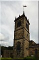
Early Medieval (Dark Age)Site Name: St Thomas Becket (Chapel en le Frith) Alternative Name: Chapel en le Frith Parish ChurchCountry: England
NOTE: This site is 0.133 km away from the location you searched for.
County: Derbyshire Type: Ancient Cross
Nearest Town: Chapel en le Frith
Map Ref: SK0574580820
Latitude: 53.324272N Longitude: 1.915212W
Condition:
| 5 | Perfect |
| 4 | Almost Perfect |
| 3 | Reasonable but with some damage |
| 2 | Ruined but still recognisable as an ancient site |
| 1 | Pretty much destroyed, possibly visible as crop marks |
| 0 | No data. |
| -1 | Completely destroyed |
| 5 | Superb |
| 4 | Good |
| 3 | Ordinary |
| 2 | Not Good |
| 1 | Awful |
| 0 | No data. |
| 5 | Can be driven to, probably with disabled access |
| 4 | Short walk on a footpath |
| 3 | Requiring a bit more of a walk |
| 2 | A long walk |
| 1 | In the middle of nowhere, a nightmare to find |
| 0 | No data. |
| 5 | co-ordinates taken by GPS or official recorded co-ordinates |
| 4 | co-ordinates scaled from a detailed map |
| 3 | co-ordinates scaled from a bad map |
| 2 | co-ordinates of the nearest village |
| 1 | co-ordinates of the nearest town |
| 0 | no data |
Internal Links:
External Links:
 (PID:30569)")
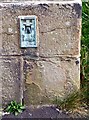
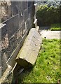
Anglo Saxon cross shaft in the churchyard, originally at SK 0232 8065.
You may be viewing yesterday's version of this page. To see the most up to date information please register for a free account.
 (PID:30570)")
Do not use the above information on other web sites or publications without permission of the contributor.
Nearby Images from Geograph Britain and Ireland:
©2017(licence)
©2017(licence)
©2017(licence)
©2015(licence)
©2019(licence)
The above images may not be of the site on this page, they are loaded from Geograph.
Please Submit an Image of this site or go out and take one for us!
Click here to see more info for this site
Nearby sites
Key: Red: member's photo, Blue: 3rd party photo, Yellow: other image, Green: no photo - please go there and take one, Grey: site destroyed
Download sites to:
KML (Google Earth)
GPX (GPS waypoints)
CSV (Garmin/Navman)
CSV (Excel)
To unlock full downloads you need to sign up as a Contributory Member. Otherwise downloads are limited to 50 sites.
Turn off the page maps and other distractions
Nearby sites listing. In the following links * = Image available
397m ENE 63° Nanny's Well (Chapel le Frith) Holy Well or Sacred Spring (SK061810)
1.1km W 264° Nanny Well* Holy Well or Sacred Spring (SK046807)
2.2km ENE 67° Mag Low* Round Barrow(s) (SK078817)
2.3km SSE 160° Cow Low* Round Barrow(s) (SK0653378666)
2.3km S 189° Castle Naze* Hillfort (SK054785)
2.8km SSE 164° Lady Low Barrow* Round Cairn (SK06537818)
2.9km ESE 112° Ebbing and Flowing Well (Chapel)* Holy Well or Sacred Spring (SK08437972)
3.0km ENE 61° Ford Hall Cairn (SK084823)
3.3km SE 141° Bullring* Henge (SK07857824)
3.4km NE 51° Green Low ringcairn* Ring Cairn (SK084830)
3.6km NW 321° Chinley Churn Barrow Round Barrow(s) (SK035836)
3.7km WSW 248° Ladder Hill* Ring Cairn (SK0230579434)
4.0km E 93° Harrod Low* Long Barrow (SK098806)
4.3km WSW 254° The Shall Cross* Ancient Cross (SK0165579615)
4.4km N 358° Mount Famine burial cist* Cist (SK056852)
5.0km N 357° Coldwell Clough Anglo Saxon cross Ancient Cross (SK055858)
5.2km E 86° Perryfoot Long Barrow (SK109812)
5.2km N 358° Fog Field Well* Holy Well or Sacred Spring (SK05578602)
5.4km N 356° White Lady standing stone* Standing Stone (Menhir) (SK0534286250)
5.6km NNE 21° Edale Cross* Ancient Cross (SK0772586092)
5.8km E 87° Eldon Hill* Round Barrow(s) (SK11568114)
5.8km WNW 282° Ringstone (Whaley Bridge) Stone Circle (SK000820)
5.9km W 277° Hawkhurst Head* Standing Stone (Menhir) (SJ99838149)
6.0km N 358° Tunstead Clough* Ancient Village or Settlement (SK055868)
6.0km NNW 347° Whitworth Well* Holy Well or Sacred Spring (SK0437786691)
View more nearby sites and additional images


 We would like to know more about this location. Please feel free to add a brief description and any relevant information in your own language.
 Wir möchten mehr über diese Stätte erfahren. Bitte zögern Sie nicht, eine kurze Beschreibung und relevante Informationen in Deutsch hinzuzufügen.
 Nous aimerions en savoir encore un peu sur les lieux. S'il vous plaît n'hesitez pas à ajouter une courte description et tous les renseignements pertinents dans votre propre langue.
 Quisieramos informarnos un poco más de las lugares. No dude en añadir una breve descripción y otros datos relevantes en su propio idioma.