

<< Text Pages >> Honrubia - Castro or Chafurdão in Spain in Castilla La Mancha y Madrid
Submitted by TheCaptain on Wednesday, 08 September 2010 Page Views: 2407
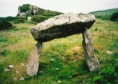
Iron Age and Later PrehistorySite Name: HonrubiaCountry: Spain
NOTE: This site is 57.236 km away from the location you searched for.
Region: Castilla La Mancha y Madrid Type: Castro or Chafurdão
Nearest Town: Albacete Nearest Village: Honrubia
Latitude: 39.614000N Longitude: 2.285W
Condition:
| 5 | Perfect |
| 4 | Almost Perfect |
| 3 | Reasonable but with some damage |
| 2 | Ruined but still recognisable as an ancient site |
| 1 | Pretty much destroyed, possibly visible as crop marks |
| 0 | No data. |
| -1 | Completely destroyed |
| 5 | Superb |
| 4 | Good |
| 3 | Ordinary |
| 2 | Not Good |
| 1 | Awful |
| 0 | No data. |
| 5 | Can be driven to, probably with disabled access |
| 4 | Short walk on a footpath |
| 3 | Requiring a bit more of a walk |
| 2 | A long walk |
| 1 | In the middle of nowhere, a nightmare to find |
| 0 | No data. |
| 5 | co-ordinates taken by GPS or official recorded co-ordinates |
| 4 | co-ordinates scaled from a detailed map |
| 3 | co-ordinates scaled from a bad map |
| 2 | co-ordinates of the nearest village |
| 1 | co-ordinates of the nearest town |
| 0 | no data |
Be the first person to rate this site - see the 'Contribute!' box in the right hand menu.
Internal Links:
External Links:
Castro in Castilla-La Mancha
Honrubia is a Castro in the community of Honrubia, Province of Albacete, region of Castilla-La Mancha
You may be viewing yesterday's version of this page. To see the most up to date information please register for a free account.
Do not use the above information on other web sites or publications without permission of the contributor.
Nearby Images from Flickr


The above images may not be of the site on this page, but were taken nearby. They are loaded from Flickr so please click on them for image credits.
Click here to see more info for this site
Nearby sites
Click here to view sites on an interactive map of the areaKey: Red: member's photo, Blue: 3rd party photo, Yellow: other image, Green: no photo - please go there and take one, Grey: site destroyed
Download sites to:
KML (Google Earth)
GPX (GPS waypoints)
CSV (Garmin/Navman)
CSV (Excel)
To unlock full downloads you need to sign up as a Contributory Member. Otherwise downloads are limited to 50 sites.
Turn off the page maps and other distractions
Nearby sites listing. In the following links * = Image available
63.2km NE 56° Selva Pascuala cave mural Cave or Rock Shelter
73.6km NE 43° Nuestra Senora del Pilar de Altarejos Castro or Chafurdão
87.4km SSW 211° Cueva de Montesinos Cave or Rock Shelter
108.9km E 79° Cueva de la Vieja* Cave or Rock Shelter
112.9km NW 308° Cuevas de Perales de Tajuña* Cave or Rock Shelter
113.6km NE 39° Masada de Ligros Castro or Chafurdão
114.4km NE 41° Arte rupestre en Albarracín* Cave or Rock Shelter
114.9km NE 46° Pena de la Cruz Castro or Chafurdão
121.4km SSE 160° Minetada Caves* Cave or Rock Shelter
122.0km NE 52° Penalba de Villastar Castro or Chafurdão
122.1km WSW 239° Motilla del Azuer* Hillfort
128.8km NE 51° Rodenas Castro or Chafurdão
132.4km SSE 158° El Canajo Castro or Chafurdão
133.5km SE 139° La Cueva Horadada* Cave or Rock Shelter
133.7km SE 139° Cantos de la Visera Rock Art
133.8km NW 316° Complutum Alcalá de Henares Ancient Village or Settlement
134.0km SE 140° Las Cazoletas del Arabilejo Ancient Village or Settlement
134.1km SE 140° Petroglifos del Arabilejo Rock Art
134.4km ESE 114° Cuevas de la Arana* Cave or Rock Shelter
144.9km N 0° La Cueva de Los Casares Cave or Rock Shelter
148.3km SE 139° Abrigo del Canto de la Visera* Cave or Rock Shelter
149.6km NW 307° Museo Arqueológico Nacional* Museum
149.9km SE 137° Tobanilla Castro or Chafurdão
150.9km W 281° Museo de Santa Cruz* Museum
151.6km NW 307° Templo de Debod* Ancient Temple
View more nearby sites and additional images


 We would like to know more about this location. Please feel free to add a brief description and any relevant information in your own language.
 Wir möchten mehr über diese Stätte erfahren. Bitte zögern Sie nicht, eine kurze Beschreibung und relevante Informationen in Deutsch hinzuzufügen.
 Nous aimerions en savoir encore un peu sur les lieux. S'il vous plaît n'hesitez pas à ajouter une courte description et tous les renseignements pertinents dans votre propre langue.
 Quisieramos informarnos un poco más de las lugares. No dude en añadir una breve descripción y otros datos relevantes en su propio idioma.