<< Our Photo Pages >> Four-És-Feins - Passage Grave in France in Bretagne:Ille-et-Vilaine (35)
Submitted by TheCaptain on Sunday, 19 December 2004 Page Views: 6019
Neolithic and Bronze AgeSite Name: Four-És-Feins Alternative Name: Allée couverte de Four-ès-FeinsCountry: France
NOTE: This site is 2.169 km away from the location you searched for.
Département: Bretagne:Ille-et-Vilaine (35) Type: Passage Grave
Nearest Town: Dol-de-Bretagne Nearest Village: Miniac Morvan
Latitude: 48.498370N Longitude: 1.91605W
Condition:
| 5 | Perfect |
| 4 | Almost Perfect |
| 3 | Reasonable but with some damage |
| 2 | Ruined but still recognisable as an ancient site |
| 1 | Pretty much destroyed, possibly visible as crop marks |
| 0 | No data. |
| -1 | Completely destroyed |
| 5 | Superb |
| 4 | Good |
| 3 | Ordinary |
| 2 | Not Good |
| 1 | Awful |
| 0 | No data. |
| 5 | Can be driven to, probably with disabled access |
| 4 | Short walk on a footpath |
| 3 | Requiring a bit more of a walk |
| 2 | A long walk |
| 1 | In the middle of nowhere, a nightmare to find |
| 0 | No data. |
| 5 | co-ordinates taken by GPS or official recorded co-ordinates |
| 4 | co-ordinates scaled from a detailed map |
| 3 | co-ordinates scaled from a bad map |
| 2 | co-ordinates of the nearest village |
| 1 | co-ordinates of the nearest town |
| 0 | no data |
Internal Links:
External Links:
I have visited· I would like to visit
TheCaptain visited on 12th Jun 2009 - their rating: Cond: 2 Amb: 4 Access: 3 I went and had another look for this while in the area last weekend, now knowing to look nearby to the Beillac farm. I could see nothing obvious when driving slowly down the lane past the farm, but there was an old couple out tending their wonderful vegetable garden, so I stopped and asked them if they could tell me where the dolmen was. They were interested to know what an Englishman was doing looking for the remnants of the dolmen, but were happy to help.
Unfortunately, I struggled to understand fully all they were saying, a combination of strong accent and using some words I just could not figure out. But I thought I had got enough of a lead to find it easily. Park out of the way of the farm track by the corner of the farm. Cross the field to the south on the newly cut hay at the edge of the field for 200 metres until reaching the other side. Go straight on about another 100 metres (unknown words) until I get to the big trees, and it is on the left, (some more unknown words). Put boots on if you have them. Sounds simple.
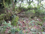
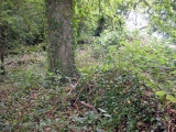
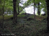
Well, it was all very simple simple, until I tried to decide which of all the woodlands were the correct big trees. However, after a few false starts, I found a place in a woodland to the left of the track, with a mound in it, and what looked to be some lumps sticking up, but it was very overgrown. It has to be this, surely. Closer inspection amongst the ivy and brambles, and there were clearly a few side set slabs sticking up through the ground, and I was pretty sure I could determine two rows of slabs about 1.5 metres apart from each other, but with no stone more than 0.5 metres tall, and most substantially lower. I reckoned that what I had found on top of the mound was about 10 metres in length, and had to be the remains of a very ruined allée couverte.
However, walking back to the car, I thought that these poor remains were not really enough to be known by the name Four-es-Feins; the Fairies Oven. Surely something with a name like that must be a grander structure. I also thought it to be too ruined to be what the old couple were explaining to me, although they did say it was just the remains of an allée couverte. I would have thought they would have told me not to bother rather than gladly give me directions.....
Upon returning to the car, I remembered I had book with description in a box in the boot. "Rectangular chamber measuring 10m by 1.5m with 6 orthostats on the south side and 5 on the north. Their length is between 1 and 1.8 metres, height about half a metre and thickness 0.3 metres. Brilliant, this all fits to what I saw. But then, the description goes on. Three cover slabs about half a metre thick, and the backstone are still in place. Around the monument, a dozen or so other stones lie scattered.
Well, I can believe the stones are now more covered by undergrowth and soil than that description, and hence seem smaller. The size, orientation and almost everything seems right, with one major exception; the three cover stones. There was nothing at all which could have been them. Read the description again and realise it has been based upon a plan and writings from 1886 and 1928. Maybe it has become much more wrecked since then, but what of the old couples talk ?
So, was this Four-es-Feins or not? If it wasn't, what had I found ? I am not sure, but like to think I did find it. Certainly until anyone proves otherwise and can show me something better I'll count it.
TheCaptain couldn't find on 28th Jun 2005 I had a good look around for the remains of this allée couverte, but could find nothing obvious. It's somewhere to the west of the hamlet of Vieux Bourg, beside the north to south expressway.
A description reads "Rectangular chamber measuring 10m by 1.5m with 6 orthostats on the south side and 5 on the north. Their length is between 1 and 1.8 metres, height about half a metre and thickness 0.3 metres. Three cover slabs about half a metre thick, and the backstone are still in place. The dolmen is oriented east to west. Around the monument, a dozen or so other stones lie scattered."
I found something which nearly matches that description, with one major exception; the three cover stones. There was nothing at all which could have been them.
IMPORTANT NOTE: Position given is of site I believe to be the megalithic remains. See comment below.
You may be viewing yesterday's version of this page. To see the most up to date information please register for a free account.

Do not use the above information on other web sites or publications without permission of the contributor.
Click here to see more info for this site
Nearby sites
Click here to view sites on an interactive map of the areaKey: Red: member's photo, Blue: 3rd party photo, Yellow: other image, Green: no photo - please go there and take one, Grey: site destroyed
Download sites to:
KML (Google Earth)
GPX (GPS waypoints)
CSV (Garmin/Navman)
CSV (Excel)
To unlock full downloads you need to sign up as a Contributory Member. Otherwise downloads are limited to 50 sites.
Turn off the page maps and other distractions
Nearby sites listing. In the following links * = Image available
1.4km W 280° Menhir du Bois de la Tougeais Standing Stone (Menhir)
1.4km W 280° Dolmen du Bois de la Tougeais Burial Chamber or Dolmen
1.4km W 279° Allée Couverte du Bois de la Tougeais Passage Grave
3.3km ESE 117° La Maison des Feins* Passage Grave
4.2km WSW 242° La Ganterie* Passage Grave
7.3km NNW 329° Enceinte dite l'Huitière* Ancient Village or Settlement
7.5km NNW 330° Le Lit de Gargantua Burial Chamber or Dolmen
7.5km W 267° Thiemblais menhir* Standing Stone (Menhir)
7.6km E 81° Menhir dit la Pierre du Domaine* Standing Stone (Menhir)
7.8km NW 326° Gravier de Gargantua (St-Suliac) Standing Stone (Menhir)
8.0km NNW 339° Dent de Gargantua* Standing Stone (Menhir)
8.7km NNW 341° La Pierre Couvretiere (St-Suliac) Burial Chamber or Dolmen
9.2km WNW 290° Beleven allée couverte* Passage Grave
9.5km NNW 330° Saint-Suliac Abri Cave or Rock Shelter
9.8km ESE 120° Bourgneuf menhir Standing Stone (Menhir)
11.0km WNW 292° La Roche-Bise Standing Stone (Menhir)
11.0km WNW 288° Champ des Roches* Multiple Stone Rows / Avenue
11.1km SE 146° Menhir du Grand-Herbage Standing Stone (Menhir)
11.6km WNW 287° Pierre de Minoz* Standing Stone (Menhir)
13.6km NE 53° Mont-Dol* Ancient Temple
13.6km ENE 72° Champ Dolent Menhir* Standing Stone (Menhir)
16.7km ESE 112° Menhir des Douères* Standing Stone (Menhir)
17.3km W 260° Temple de Mars* Ancient Temple
18.3km ESE 123° Allée Couverte de Chevrot Passage Grave
18.5km W 264° Monterfil* Ancient Village or Settlement
View more nearby sites and additional images




 We would like to know more about this location. Please feel free to add a brief description and any relevant information in your own language.
 Wir möchten mehr über diese Stätte erfahren. Bitte zögern Sie nicht, eine kurze Beschreibung und relevante Informationen in Deutsch hinzuzufügen.
 Nous aimerions en savoir encore un peu sur les lieux. S'il vous plaît n'hesitez pas à ajouter une courte description et tous les renseignements pertinents dans votre propre langue.
 Quisieramos informarnos un poco más de las lugares. No dude en añadir una breve descripción y otros datos relevantes en su propio idioma.