 with our Megalithic Portal iPhone app")


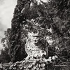
<< Our Photo Pages >> Menhir des Pins - Standing Stone (Menhir) in France in Pays de la Loire:Loire-Atlantique
Submitted by Dipo on Tuesday, 19 August 2008 Page Views: 3853
Neolithic and Bronze AgeSite Name: Menhir des PinsCountry: France
NOTE: This site is 3.731 km away from the location you searched for.
Département: Pays de la Loire:Loire-Atlantique Type: Standing Stone (Menhir)
Nearest Town: Saint Nazaire Nearest Village: Frossay
Latitude: 47.243300N Longitude: 1.92117W
Condition:
| 5 | Perfect |
| 4 | Almost Perfect |
| 3 | Reasonable but with some damage |
| 2 | Ruined but still recognisable as an ancient site |
| 1 | Pretty much destroyed, possibly visible as crop marks |
| 0 | No data. |
| -1 | Completely destroyed |
| 5 | Superb |
| 4 | Good |
| 3 | Ordinary |
| 2 | Not Good |
| 1 | Awful |
| 0 | No data. |
| 5 | Can be driven to, probably with disabled access |
| 4 | Short walk on a footpath |
| 3 | Requiring a bit more of a walk |
| 2 | A long walk |
| 1 | In the middle of nowhere, a nightmare to find |
| 0 | No data. |
| 5 | co-ordinates taken by GPS or official recorded co-ordinates |
| 4 | co-ordinates scaled from a detailed map |
| 3 | co-ordinates scaled from a bad map |
| 2 | co-ordinates of the nearest village |
| 1 | co-ordinates of the nearest town |
| 0 | no data |
Internal Links:
External Links:
")
Located 1km Est of Frossay. Alongside a large path.
2.80m hight, 0.90m wide and 0.70m thick
You may be viewing yesterday's version of this page. To see the most up to date information please register for a free account.
")
")
")
Do not use the above information on other web sites or publications without permission of the contributor.
Nearby Images from Flickr


The above images may not be of the site on this page, but were taken nearby. They are loaded from Flickr so please click on them for image credits.
Click here to see more info for this site
Nearby sites
Click here to view sites on an interactive map of the areaKey: Red: member's photo, Blue: 3rd party photo, Yellow: other image, Green: no photo - please go there and take one, Grey: site destroyed
Download sites to:
KML (Google Earth)
GPX (GPS waypoints)
CSV (Garmin/Navman)
CSV (Excel)
To unlock full downloads you need to sign up as a Contributory Member. Otherwise downloads are limited to 50 sites.
Turn off the page maps and other distractions
Nearby sites listing. In the following links * = Image available
6.4km SE 139° Menhir de La Génonville Standing Stone (Menhir)
7.3km N 6° Pierre Des Huguenots* Standing Stone (Menhir)
7.8km SW 219° Menhir du Bois des Vallées Standing Stone (Menhir)
8.0km WNW 296° Menhir de la Tuterie* Standing Stone (Menhir)
8.7km SW 230° Menhir de Biais Standing Stone (Menhir)
8.9km WNW 300° Pierre Pointue (Paimboeuf)* Standing Stone (Menhir)
9.8km SW 232° Le Rocher (Le Chatelier) Rock Art
10.2km SW 228° Platennes Menhirs* Stone Row / Alignment
10.5km SW 228° Chevanou Menhir* Standing Stones
10.6km SW 225° La Pierre Le Matz* Standing Stone (Menhir)
10.6km SSE 166° Pierre Levée (Cheméré)* Standing Stone (Menhir)
11.0km W 267° La Roche Govi Menhir* Standing Stone (Menhir)
11.2km W 280° Menhir dit la Pierre Bonde* Standing Stone (Menhir)
11.2km WNW 282° La Haute Gedeliere Dolmen* Passage Grave
11.2km W 271° La Gauterie Dolmen* Burial Chamber or Dolmen
11.9km WNW 284° Les Pierres Blanches (Corsept)* Standing Stones
12.0km W 267° Les Landes Menhir* Standing Stone (Menhir)
12.1km W 273° Megerie Menhir* Standing Stone (Menhir)
12.3km W 265° La Bellevue Menhir* Standing Stone (Menhir)
12.5km W 273° Cassis Menhir* Standing Stone (Menhir)
12.9km NW 305° Menhir de la Vacherie (Donges)* Standing Stone (Menhir)
12.9km NW 305° Dolmen de la Vacherie (Donges)* Burial Chamber or Dolmen
13.2km SW 219° Dolmen de La Boissonnière Burial Chamber or Dolmen
14.1km WNW 303° La Roche Dolmen (Donges) Burial Chamber or Dolmen
14.2km WSW 254° Le Riverais 2* Standing Stone (Menhir)
View more nearby sites and additional images


 We would like to know more about this location. Please feel free to add a brief description and any relevant information in your own language.
 Wir möchten mehr über diese Stätte erfahren. Bitte zögern Sie nicht, eine kurze Beschreibung und relevante Informationen in Deutsch hinzuzufügen.
 Nous aimerions en savoir encore un peu sur les lieux. S'il vous plaît n'hesitez pas à ajouter une courte description et tous les renseignements pertinents dans votre propre langue.
 Quisieramos informarnos un poco más de las lugares. No dude en añadir una breve descripción y otros datos relevantes en su propio idioma.