


<< Our Photo Pages >> Keeper's Well - Holy Well or Sacred Spring in England in Warwickshire
Submitted by HOLYWELL on Friday, 04 February 2011 Page Views: 8114
Springs and Holy WellsSite Name: Keeper's WellCountry: England
NOTE: This site is 5.429 km away from the location you searched for.
County: Warwickshire Type: Holy Well or Sacred Spring
Nearest Town: Sutton Coldfield
Map Ref: SP1049296613
Latitude: 52.567245N Longitude: 1.84664W
Condition:
| 5 | Perfect |
| 4 | Almost Perfect |
| 3 | Reasonable but with some damage |
| 2 | Ruined but still recognisable as an ancient site |
| 1 | Pretty much destroyed, possibly visible as crop marks |
| 0 | No data. |
| -1 | Completely destroyed |
| 5 | Superb |
| 4 | Good |
| 3 | Ordinary |
| 2 | Not Good |
| 1 | Awful |
| 0 | No data. |
| 5 | Can be driven to, probably with disabled access |
| 4 | Short walk on a footpath |
| 3 | Requiring a bit more of a walk |
| 2 | A long walk |
| 1 | In the middle of nowhere, a nightmare to find |
| 0 | No data. |
| 5 | co-ordinates taken by GPS or official recorded co-ordinates |
| 4 | co-ordinates scaled from a detailed map |
| 3 | co-ordinates scaled from a bad map |
| 2 | co-ordinates of the nearest village |
| 1 | co-ordinates of the nearest town |
| 0 | no data |
Internal Links:
External Links:
I have visited· I would like to visit
Twistytwirly would like to visit
")
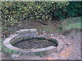
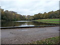
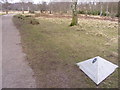
Keepers Well is named after a John Holt during the time of Edward IV. He was thought to be a druid and the water like the other pools in the park to have special properties. It is on the South side of the path leading up the stream which feeds Keeper's Pool. Proximity of ancient roads such as the Roman road may be significant.
You may be viewing yesterday's version of this page. To see the most up to date information please register for a free account.
")
Do not use the above information on other web sites or publications without permission of the contributor.
Nearby Images from Geograph Britain and Ireland:
©2009(licence)
©2009(licence)
©2010(licence)
©2015(licence)
©2013(licence)
The above images may not be of the site on this page, they are loaded from Geograph.
Please Submit an Image of this site or go out and take one for us!
Click here to see more info for this site
Nearby sites
Key: Red: member's photo, Blue: 3rd party photo, Yellow: other image, Green: no photo - please go there and take one, Grey: site destroyed
Download sites to:
KML (Google Earth)
GPX (GPS waypoints)
CSV (Garmin/Navman)
CSV (Excel)
To unlock full downloads you need to sign up as a Contributory Member. Otherwise downloads are limited to 50 sites.
Turn off the page maps and other distractions
Nearby sites listing. In the following links * = Image available
1.2km W 264° Rowton Well* Holy Well or Sacred Spring (SP0927496487)
1.4km NNW 347° Druid's Well (Sutton Park) Holy Well or Sacred Spring (SP1016297991)
2.7km WSW 248° The King's Standing* Round Barrow(s) (SP080956)
5.9km NE 48° St Modwen's Well (Canwell) Holy Well or Sacred Spring (SK14890058)
9.6km WSW 236° St Augustine's Well (Sandwell)* Holy Well or Sacred Spring (SP0248391296)
10.1km SSW 208° War Stone* Natural Stone / Erratic / Other Natural Feature (SP058877)
10.1km N 356° Wall Roman sites (Letocetum)* Ancient Village or Settlement (SK0977506660)
10.5km SSW 202° Birmingham Museum & Art Gallery Museum (SP066869)
11.4km SE 127° Beggars Well* Holy Well or Sacred Spring (SP1962989822)
12.5km NE 55° St Ruffin's Well (Tamworth)* Holy Well or Sacred Spring (SK207038)
13.8km N 7° St Chad's Well (Lichfield)* Holy Well or Sacred Spring (SK122103)
14.4km SSW 204° Lapworth Museum Museum (SP047834)
14.6km S 172° Burnt mound in Fox Hollies Park Artificial Mound (SP1247182177)
14.6km S 185° Moseley Bog Burnt Mound* Artificial Mound (SP0934382043)
14.9km NW 308° The Great Stones of Landywood* Stone Circle (SJ9872805826)
16.4km NNW 338° Nun's Well (Cannock Wood)* Holy Well or Sacred Spring (SK04151180)
17.2km NNW 340° Castle Ring (Staffordshire)* Hillfort (SK045128)
18.4km NNE 15° Alrewas Causewayed Enclosure* Causewayed Enclosure (SK15351436)
18.8km S 183° Berry Mound* Hillfort (SP095778)
18.9km NE 35° Stone in Croxall Churchyard* Marker Stone (SK2140512127)
19.1km N 3° King's Bromley Cursus Cursus (SK116157)
19.1km W 277° St Peter (Wolverhampton)* Ancient Cross (SO9141998765)
19.3km W 277° The Bargain Stone* Holed Stone (SO913989)
19.6km NNE 22° Alrewas Cursus* Cursus (SK177149)
19.6km NNE 22° Alrewas and Fradley Cursus Cursus (SK177149)
View more nearby sites and additional images


 We would like to know more about this location. Please feel free to add a brief description and any relevant information in your own language.
 Wir möchten mehr über diese Stätte erfahren. Bitte zögern Sie nicht, eine kurze Beschreibung und relevante Informationen in Deutsch hinzuzufügen.
 Nous aimerions en savoir encore un peu sur les lieux. S'il vous plaît n'hesitez pas à ajouter une courte description et tous les renseignements pertinents dans votre propre langue.
 Quisieramos informarnos un poco más de las lugares. No dude en añadir una breve descripción y otros datos relevantes en su propio idioma.