


<< Our Photo Pages >> Ablington Camp - Hillfort in England in Gloucestershire
Submitted by 4clydesdale7 on Saturday, 16 July 2011 Page Views: 4741
Iron Age and Later PrehistorySite Name: Ablington Camp Alternative Name: Rawbarrow CampCountry: England
NOTE: This site is 1.343 km away from the location you searched for.
County: Gloucestershire Type: Hillfort
Nearest Village: Ablington
Map Ref: SP105074
Latitude: 51.765184N Longitude: 1.849252W
Condition:
| 5 | Perfect |
| 4 | Almost Perfect |
| 3 | Reasonable but with some damage |
| 2 | Ruined but still recognisable as an ancient site |
| 1 | Pretty much destroyed, possibly visible as crop marks |
| 0 | No data. |
| -1 | Completely destroyed |
| 5 | Superb |
| 4 | Good |
| 3 | Ordinary |
| 2 | Not Good |
| 1 | Awful |
| 0 | No data. |
| 5 | Can be driven to, probably with disabled access |
| 4 | Short walk on a footpath |
| 3 | Requiring a bit more of a walk |
| 2 | A long walk |
| 1 | In the middle of nowhere, a nightmare to find |
| 0 | No data. |
| 5 | co-ordinates taken by GPS or official recorded co-ordinates |
| 4 | co-ordinates scaled from a detailed map |
| 3 | co-ordinates scaled from a bad map |
| 2 | co-ordinates of the nearest village |
| 1 | co-ordinates of the nearest town |
| 0 | no data |
Internal Links:
External Links:
I have visited· I would like to visit
4clydesdale7 visited on 14th Jul 2011 - their rating: Cond: 2 Amb: 4 Access: 4 I must return to carry out a more detailed investigation of the SE and E sides
")
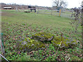
This site is a univallate hillfort built on a promontory jutting out over a scarp on the S side of the River Coln - it was listed by Witts - the earthworks consist of (in the main) a single U shaped bank with the open end being the scarp to the North - towards the SE and on the E there is some evidence of a possible second bank - the Inner Camp is now laid to pasture and extends over approx. 8 acres - the vast majority of the earthworks have been ploughed out but there is some evidence remaining of an entrance to the SE - on the footpath towards this is a wild english rose bush growing from the bank which enhances a summer visit - it is mentioned on the Pastscape website (No 329713)
You may be viewing yesterday's version of this page. To see the most up to date information please register for a free account.
")
Do not use the above information on other web sites or publications without permission of the contributor.
Nearby Images from Geograph Britain and Ireland:
![SP1007 : A circular walk around Bibury and Ablington [11] by Michael Dibb](https://s1.geograph.org.uk/geophotos/07/48/93/7489317_3149e33e_120x120.jpg)
©2023(licence)
![SP1007 : A circular walk around Bibury and Ablington [10] by Michael Dibb](https://s0.geograph.org.uk/geophotos/07/48/93/7489316_90b88654_120x120.jpg)
©2023(licence)
![SP1007 : A circular walk around Bibury and Ablington [8] by Michael Dibb](https://s2.geograph.org.uk/geophotos/07/48/93/7489314_97bec6f5_120x120.jpg)
©2023(licence)
©2022(licence)
![SP1007 : A circular walk around Bibury and Ablington [7] by Michael Dibb](https://s0.geograph.org.uk/geophotos/07/48/93/7489312_663e720a_120x120.jpg)
©2023(licence)
The above images may not be of the site on this page, they are loaded from Geograph.
Please Submit an Image of this site or go out and take one for us!
Click here to see more info for this site
Nearby sites
Key: Red: member's photo, Blue: 3rd party photo, Yellow: other image, Green: no photo - please go there and take one, Grey: site destroyed
Download sites to:
KML (Google Earth)
GPX (GPS waypoints)
CSV (Garmin/Navman)
CSV (Excel)
To unlock full downloads you need to sign up as a Contributory Member. Otherwise downloads are limited to 50 sites.
Turn off the page maps and other distractions
Nearby sites listing. In the following links * = Image available
1.9km NNE 13° Ablington Long Barrow Chambered Tomb (SP10910925)
2.0km NNE 31° Saltway Barn Chambered Cairn (SP115091)
2.0km N 7° Lamborough Banks* Chambered Cairn (SP10760942)
3.8km WNW 285° Colnpen* Chambered Tomb (SP068084)
4.4km N 355° Crickley Barrow Chambered Tomb (SP101118)
6.1km WNW 282° Calmsden spring* Holy Well or Sacred Spring (SP04540863)
6.2km ENE 78° Ladborough Camp* Hillfort (SP16540870)
6.2km NW 322° Woodbarrow (Glos)* Chambered Tomb (SP067123)
6.3km NW 322° Royal Oak* Round Barrow(s) (SP066123)
6.4km NE 36° Lodge Park* Long Barrow (SP1426712550)
6.4km ESE 120° Barrow Elm* Round Barrow(s) (SP16110420)
6.5km ENE 69° Lad Barrow* Chambered Tomb (SP166097)
6.7km SSW 193° Ranbury Ring* Hillfort (SP090009)
6.8km WNW 298° Pinkwell (Chedworth)* Chambered Cairn (SP045106)
7.0km NW 312° Chedworth spring* Holy Well or Sacred Spring (SP053121)
7.9km NNW 347° Hangman's Stone (Northleach)* Standing Stone (Menhir) (SP087151)
8.1km NW 319° Chedworth Villa Nymphaeum* Holy Well or Sacred Spring (SP052135)
8.3km NNE 13° Norbury Hillfort Barrow* Chambered Tomb (SP124155)
8.5km NW 321° Round barrow N of Chedworth Roman villa* Round Barrow(s) (SP0511013931)
8.6km NNE 16° Norbury Hillfort (Farmington)* Hillfort (SP128157)
8.6km W 271° North Cerney 1* Chambered Tomb (SP01840752)
8.7km N 359° Burn Ground* Chambered Cairn (SP104161)
8.7km NNW 348° Furzenhill Barn* Chambered Tomb (SP086159)
8.7km W 264° Bagendon* Hillfort (SP018064)
8.8km WSW 237° Tar Barrow* Round Barrow(s) (SP03110252)
View more nearby sites and additional images


 We would like to know more about this location. Please feel free to add a brief description and any relevant information in your own language.
 Wir möchten mehr über diese Stätte erfahren. Bitte zögern Sie nicht, eine kurze Beschreibung und relevante Informationen in Deutsch hinzuzufügen.
 Nous aimerions en savoir encore un peu sur les lieux. S'il vous plaît n'hesitez pas à ajouter une courte description et tous les renseignements pertinents dans votre propre langue.
 Quisieramos informarnos un poco más de las lugares. No dude en añadir una breve descripción y otros datos relevantes en su propio idioma.