


<< Our Photo Pages >> Abbot's Hand - Marker Stone in England in Yorkshire (North)
Submitted by rogerkread on Tuesday, 11 August 2020 Page Views: 707
Modern SitesSite Name: Abbot's Hand Alternative Name: Pallas-stoneCountry: England
NOTE: This site is 3.278 km away from the location you searched for.
County: Yorkshire (North) Type: Marker Stone
Nearest Town: Pateley Bridge Nearest Village: Greenhow
Map Ref: SE138614
Latitude: 54.048383N Longitude: 1.790726W
Condition:
| 5 | Perfect |
| 4 | Almost Perfect |
| 3 | Reasonable but with some damage |
| 2 | Ruined but still recognisable as an ancient site |
| 1 | Pretty much destroyed, possibly visible as crop marks |
| 0 | No data. |
| -1 | Completely destroyed |
| 5 | Superb |
| 4 | Good |
| 3 | Ordinary |
| 2 | Not Good |
| 1 | Awful |
| 0 | No data. |
| 5 | Can be driven to, probably with disabled access |
| 4 | Short walk on a footpath |
| 3 | Requiring a bit more of a walk |
| 2 | A long walk |
| 1 | In the middle of nowhere, a nightmare to find |
| 0 | No data. |
| 5 | co-ordinates taken by GPS or official recorded co-ordinates |
| 4 | co-ordinates scaled from a detailed map |
| 3 | co-ordinates scaled from a bad map |
| 2 | co-ordinates of the nearest village |
| 1 | co-ordinates of the nearest town |
| 0 | no data |
Internal Links:
External Links:
")
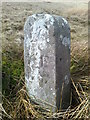
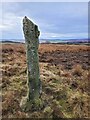
There are various inscriptions: a cross; the number 16 which may be the first part of a date, the remainder having broken away (it's on the narrower top part); a clear letter R and a much weathered second letter, looking most like an I now, to me, but reported as a P by one author and an F by another. There may be other inscriptions as well, it is severely weathered.
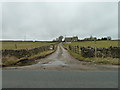
It is just south of a track called Plumpton Way on some modern maps, or Plumpton Gate in the past.
It is mentioned in at least two of the documents associated with determining the extent of the Forest of Knaresborough just prior to its enclosure in the late C18th, and is described as 'of great age' in a 1576 perambulation document.
Likely purposes are either marking Fountains Abbey lands, Roger Frank (RF) being Abbot from 1410, or land granted to Robert Plumpton (RP) by Henry VI. Or indeed both.
You may be viewing yesterday's version of this page. To see the most up to date information please register for a free account.
")
")
")
Do not use the above information on other web sites or publications without permission of the contributor.
Nearby Images from Geograph Britain and Ireland:
©2020(licence)
©2023(licence)
©2019(licence)
©2019(licence)
©2013(licence)
The above images may not be of the site on this page, they are loaded from Geograph.
Please Submit an Image of this site or go out and take one for us!
Click here to see more info for this site
Nearby sites
Key: Red: member's photo, Blue: 3rd party photo, Yellow: other image, Green: no photo - please go there and take one, Grey: site destroyed
Download sites to:
KML (Google Earth)
GPX (GPS waypoints)
CSV (Garmin/Navman)
CSV (Excel)
To unlock full downloads you need to sign up as a Contributory Member. Otherwise downloads are limited to 50 sites.
Turn off the page maps and other distractions
Nearby sites listing. In the following links * = Image available
3.0km NE 53° Hayshaw Moor North (Dacre) Cairn (SE1621863253)
3.2km NE 46° Guisecliff Wood (626)* Rock Art (SE1607863641)
3.4km NE 50° Guisecliff Wood (629)* Rock Art (SE1641563565)
3.8km SSW 209° Rocking Moor Rock Art (SE1193458081)
3.9km SSW 210° Raven Stones (559) Rock Art (SE1183558006)
4.4km ESE 110° Dacre Top* Ancient Village or Settlement (SE179599)
4.7km E 86° Eastwoods Rough 3 (Dacre) Rock Art (SE18506177)
4.7km W 271° Ellers Edge (432) Rock Art (SE0907861479)
4.7km W 271° Ellers Edge (431) Rock Art (SE0905961506)
4.7km E 83° Eastwoods Cross Base (Summerbridge) Rock Art (SE1850662013)
4.7km E 83° Eastwoods Farm Cup (Heyshaw)* Rock Art (SE1852062010)
4.8km E 85° Morphing Stone (Dacre)* Rock Art (SE1855961795)
4.8km W 271° Eller Edge (429) Rock Art (SE09026150)
4.8km E 87° Tadpole Stone (Eastwoods Rough)* Rock Art (SE1860161644)
4.8km W 271° Eller Edge (426) Rock Art (SE0899161486)
4.8km E 80° Fertility Stone (CR-638)* Rock Art (SE1855262228)
4.8km W 271° Eller Edge (424) Rock Art (SE0897361487)
4.8km E 80° Eastwoods Farm 01 (Heyshaw) Rock Art (SE1855662240)
4.8km E 81° Eastwoods Farm 02 (Heyshaw) Rock Art (SE1857262168)
4.9km E 80° Bryan's Wood 01 Rock Art (SE1866362280)
5.7km W 271° Burnett's Ridge (Appletreewick)* Rock Art (SE0810361500)
6.0km W 274° Skyreholme Rock Art* Rock Art (SE078618)
6.0km S 180° The Dovestones* Stone Circle (SE138554)
6.0km W 274° Burhill Kiln (Appletreewick) Rock Art (SE0778761834)
6.1km WSW 255° Simon's Seat (Skyreholme) Natural Stone / Erratic / Other Natural Feature (SE07885981)
View more nearby sites and additional images


 We would like to know more about this location. Please feel free to add a brief description and any relevant information in your own language.
 Wir möchten mehr über diese Stätte erfahren. Bitte zögern Sie nicht, eine kurze Beschreibung und relevante Informationen in Deutsch hinzuzufügen.
 Nous aimerions en savoir encore un peu sur les lieux. S'il vous plaît n'hesitez pas à ajouter une courte description et tous les renseignements pertinents dans votre propre langue.
 Quisieramos informarnos un poco más de las lugares. No dude en añadir una breve descripción y otros datos relevantes en su propio idioma.