


<< Our Photo Pages >> St Mary and St Alkelda - Ancient Cross in England in Yorkshire (North)
Submitted by Anne T on Saturday, 29 April 2017 Page Views: 1464
Early Medieval (Dark Age)Site Name: St Mary and St AlkeldaCountry: England County: Yorkshire (North) Type: Ancient Cross
Nearest Town: Middleham
Map Ref: SE1262887878
Latitude: 54.286380N Longitude: 1.807525W
Condition:
| 5 | Perfect |
| 4 | Almost Perfect |
| 3 | Reasonable but with some damage |
| 2 | Ruined but still recognisable as an ancient site |
| 1 | Pretty much destroyed, possibly visible as crop marks |
| 0 | No data. |
| -1 | Completely destroyed |
| 5 | Superb |
| 4 | Good |
| 3 | Ordinary |
| 2 | Not Good |
| 1 | Awful |
| 0 | No data. |
| 5 | Can be driven to, probably with disabled access |
| 4 | Short walk on a footpath |
| 3 | Requiring a bit more of a walk |
| 2 | A long walk |
| 1 | In the middle of nowhere, a nightmare to find |
| 0 | No data. |
| 5 | co-ordinates taken by GPS or official recorded co-ordinates |
| 4 | co-ordinates scaled from a detailed map |
| 3 | co-ordinates scaled from a bad map |
| 2 | co-ordinates of the nearest village |
| 1 | co-ordinates of the nearest town |
| 0 | no data |
Be the first person to rate this site - see the 'Contribute!' box in the right hand menu.
Internal Links:
External Links:
I have visited· I would like to visit
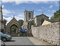
Anne T visited on 27th Apr 2017 - their rating: Cond: 3 Amb: 4 Access: 4 Anglo Saxon Cross Fragment, Middleham: On the way to the holy well, we stopped off to look at the porch of St. Mary’s & St. Alkeld, but evensong was one, so we couldn't go inside but carried on westwards through the churchyard into the fields beyond to find St. Alkelda’s Well.
At home (29th April) reading through the entry from British Listed Buildings, I noted there was mention of a cross shaft fragment built into the floor of the nave. I looked up my photographs from 19th August 2013, when we’d had a holiday cottage not far away, at a time when we weren’t looking for Anglo Saxon cross fragments, and there was one photograph.
After a brief look around the exterior of the church, we carried on through the churchyard to find the site of St. Alkelda's Well.
")
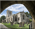
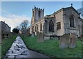
The church of St. Mary and St. Alkelda is situated not far from both the market cross and the castle in the centre of this old market town. Middleham is perhaps best known for being the childhood home of Richard III, who was the ward of Richard Neville, Earl of Warwick who was also known as 'The Kingmaker'.
The Middleham Online history page tells us "There has been a settlement here since Roman times and Middleham is mentioned in the Domesday Book when its name was `Medelai`."
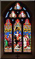
The church is largely 14th and 15th century, having been elevated to a collegiate church in 1477 by Richard, Duke of Gloucester (later Richard III) and his wife, Anne Neville. The church is listed, see British Listed Buildings Entry 101318544, which tells us: "in (the) nave floor part of Saxon cross-shaft with interlaced carving." In the porch, above the door into the church, is a very interesting carving from the 14th century of the crucifixion, together with stained glass which includes a scene of the martyrdom of St. Alkelda.
You may be viewing yesterday's version of this page. To see the most up to date information please register for a free account.
Do not use the above information on other web sites or publications without permission of the contributor.
Nearby Images from Geograph Britain and Ireland:
©2018(licence)
©2018(licence)
©2021(licence)
©2022(licence)
©2018(licence)
The above images may not be of the site on this page, they are loaded from Geograph.
Please Submit an Image of this site or go out and take one for us!
Click here to see more info for this site
Nearby sites
Key: Red: member's photo, Blue: 3rd party photo, Yellow: other image, Green: no photo - please go there and take one, Grey: site destroyed
Download sites to:
KML (Google Earth)
GPX (GPS waypoints)
CSV (Garmin/Navman)
CSV (Excel)
To unlock full downloads you need to sign up as a Contributory Member. Otherwise downloads are limited to 50 sites.
Turn off the page maps and other distractions
Nearby sites listing. In the following links * = Image available
228m W 276° St Alkelda's Holy Well* Holy Well or Sacred Spring (SE124879)
1.8km N 354° Fairy Well (Harmby)* Holy Well or Sacred Spring (SE12448969)
3.8km WNW 296° Holy Trinity (Wensley)* Ancient Cross (SE09228954)
4.3km E 98° Richard Wood South (Thornton Steward) Rock Art (SE1694087301)
5.5km S 171° Agra Moor Standing Stone* Standing Stone (Menhir) (SE1349982440)
6.3km SSE 165° West Agra* Rock Art (SE14248175)
6.4km SSE 167° West Agra Carving 2b Rock Art (SE1412681669)
6.4km SSE 166° West Agra 3a and 3b* Rock Art (SE1423681675)
6.4km SSE 167° West Agra Carving 1 Rock Art (SE1406981627)
6.6km SSE 160° Gollinglith Foot (West Agra) Standing Stone (Menhir) (SE149817)
7.2km NE 36° St Oswald (East Hauxwell)* Ancient Cross (SE168937)
8.1km SSE 148° Healey Stone Circles (Masham) Stone Circle (SE170810)
9.7km W 259° Burton Moor* Ancient Village or Settlement (SE03118604)
9.8km SE 133° Fearby Cross (Masham) Ancient Cross (SE1984081273)
10.2km SE 143° Fearby, Masham* Stone Circle (SE188798)
10.4km SSE 152° Swinton Druid's Temple* Modern Stone Circle etc (SE1746478713)
10.9km ESE 104° St Mary (Thornton Watlass)* Ancient Cross (SE2324585265)
11.5km SSE 148° Skew Skell Well* Holy Well or Sacred Spring (SE1876078084)
12.0km SE 133° Berry Well* Holy Well or Sacred Spring (SE2140479628)
12.1km W 279° St Matthew's Well (Carperby)* Holy Well or Sacred Spring (SE0065689756)
12.1km W 279° Carperby Cross* Ancient Cross (SE0063189729)
12.3km SE 126° St Mary (Masham)* Ancient Cross (SE2266080651)
13.3km NW 317° Harkerside Moor circle* Stone Circle (SE035976)
13.6km SE 140° Himalayan Gardens & Sculpture Park* Modern Stone Circle etc (SE2139577417)
13.7km NNW 339° Forty Acres 03 (Stelling) Rock Art (NZ07580058)
View more nearby sites and additional images


 We would like to know more about this location. Please feel free to add a brief description and any relevant information in your own language.
 Wir möchten mehr über diese Stätte erfahren. Bitte zögern Sie nicht, eine kurze Beschreibung und relevante Informationen in Deutsch hinzuzufügen.
 Nous aimerions en savoir encore un peu sur les lieux. S'il vous plaît n'hesitez pas à ajouter une courte description et tous les renseignements pertinents dans votre propre langue.
 Quisieramos informarnos un poco más de las lugares. No dude en añadir una breve descripción y otros datos relevantes en su propio idioma.