 with our Megalithic Portal iPhone app")
, Aubrey Burl")
<< Our Photo Pages >> Ryton Motte or Tumulus - Artificial Mound in England in Tyne and Wear
Submitted by durhamnature on Wednesday, 18 July 2012 Page Views: 4770
Multi-periodSite Name: Ryton Motte or TumulusCountry: England
NOTE: This site is 1.438 km away from the location you searched for.
County: Tyne and Wear Type: Artificial Mound
Nearest Town: Blaydon Nearest Village: Ryton
Map Ref: NZ15176483
Latitude: 54.977850N Longitude: 1.764521W
Condition:
| 5 | Perfect |
| 4 | Almost Perfect |
| 3 | Reasonable but with some damage |
| 2 | Ruined but still recognisable as an ancient site |
| 1 | Pretty much destroyed, possibly visible as crop marks |
| 0 | No data. |
| -1 | Completely destroyed |
| 5 | Superb |
| 4 | Good |
| 3 | Ordinary |
| 2 | Not Good |
| 1 | Awful |
| 0 | No data. |
| 5 | Can be driven to, probably with disabled access |
| 4 | Short walk on a footpath |
| 3 | Requiring a bit more of a walk |
| 2 | A long walk |
| 1 | In the middle of nowhere, a nightmare to find |
| 0 | No data. |
| 5 | co-ordinates taken by GPS or official recorded co-ordinates |
| 4 | co-ordinates scaled from a detailed map |
| 3 | co-ordinates scaled from a bad map |
| 2 | co-ordinates of the nearest village |
| 1 | co-ordinates of the nearest town |
| 0 | no data |
Internal Links:
External Links:
I have visited· I would like to visit
Anne T visited on 23rd Apr 2017 - their rating: Cond: 3 Amb: 4 Access: 4 Ryton Motte, Gateshead: Parking on the main road opposite The Old Cross pub and Holy Cross church on Barnmoor Lane, as there was an event on at the church, the first surprise was to see the old cross located on the village green.
Pastscape reveals this is relatively modern, having been erected in 1765, but the base looks much, much older. Historic England say in list entry 1018642 that there was evidence of an earlier cross on this site.
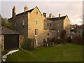
A stream of very well dressed people were exiting the church yard, indicating a service had just finished. I spent a few minutes photographing the cross, then we sauntered in the churchyard. The name board on the gate to the churchyard says that the church was founded in 1220, and whilst there appears to be old stones in the fabric of the church, popping our head into the church itself, it looks very Victorian. There were people inside, so we didn’t linger.
Walking round the tower at the west end of the church, and round to the north wall, we came across a man digging up brambles and dock plants around the graves. He told us he wasn’t’ associated with the church, but had got fed up of the graveyard looking as it did. He also said he’d just removed shrubbery and brambles off the motte, which looked bare and brown in the warm sunlight. He also told us to look out for the grave of a woman to the north-west of the motte, which had inscribed on the headstone about the grave also containing her husband, who’d lost his arm at Trafalgar.
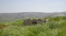
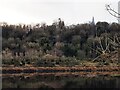
The motte is certainly a significant structure (I thought it was only small, but it’s not, measuring 3.30 metres with a diameter of 30 metres, according to Pastscape. The mound certainly appears much higher when viewed from the river side, where it looms high above you.
These days, the river is largely hidden by trees, but glimpses of silver water appear as you follow the path round the motte and back up to the east side of the church. It would have had a very commanding spot above the river when it was built.
")
Artificial mound overlooking the River Tyne. Now within the grounds of Holy Cross Church, Ryton. Formerly thought to be a barrow, and marked as a tumulus on older OS maps, but recently re-assessed and now said to be an early medieval motte.
The mound has been damaged by a Victorian investigation, and by encroachment from the church's burial ground. In 2012 it looked rather neglected and overgrown. There is easy access from the churchyard.
For further information, visit Pastscape Monument No. 22888 and Historic England ID 1018677.
You may be viewing yesterday's version of this page. To see the most up to date information please register for a free account.
")
")
")
")
Do not use the above information on other web sites or publications without permission of the contributor.
Nearby Images from Geograph Britain and Ireland:
©2011(licence)
©2011(licence)
©2011(licence)
©2011(licence)
©2023(licence)
The above images may not be of the site on this page, they are loaded from Geograph.
Please Submit an Image of this site or go out and take one for us!
Click here to see more info for this site
Nearby sites
Key: Red: member's photo, Blue: 3rd party photo, Yellow: other image, Green: no photo - please go there and take one, Grey: site destroyed
Download sites to:
KML (Google Earth)
GPX (GPS waypoints)
CSV (Garmin/Navman)
CSV (Excel)
To unlock full downloads you need to sign up as a Contributory Member. Otherwise downloads are limited to 50 sites.
Turn off the page maps and other distractions
Nearby sites listing. In the following links * = Image available
756m SSW 209° Ryton 1 Rock Art (NZ1480064170)
976m W 263° Ryton 3 Rock Art (NZ1420064700)
1.4km SSW 198° The Ryton Stone Rock Art (NZ1475063500)
1.5km SSW 207° Ryton 2 Rock Art (NZ1450063500)
1.9km N 349° Throckley Bank Portable Rock Art (NZ1482066670)
1.9km N 350° Throckley Bank Top Rock Art (NZ1482866677)
1.9km ESE 123° Stella enclosure Ancient Village or Settlement (NZ168638)
2.2km W 265° Simmery Hill Cist, Clara Vale* Cist (NZ13026462)
2.6km NW 324° Hadrian's Wall (Heddon on the Wall)* Misc. Earthwork (NZ13616693)
2.7km NW 319° St Andrew's Church (Heddon on the Wall)* Ancient Cross (NZ1338666892)
2.8km ESE 121° Summerhill Cists* Cist (NZ176634)
3.1km WSW 238° Bradley Hall Dene Barrow Round Barrow(s) (NZ12536317)
3.1km S 185° Holy Well, Greenside* Holy Well or Sacred Spring (NZ14936170)
3.3km WSW 243° Bradley Hall Ice House Barrow Round Barrow(s) (NZ12236333)
3.3km NNE 15° Dewley Burn Artificial Mound (NZ1601868016)
3.4km SW 219° White Well, Greenside* Holy Well or Sacred Spring (NZ13036222)
3.4km WNW 301° Houghton Camp, Heddon on the Hill* Ancient Village or Settlement (NZ12246657)
4.0km NNE 14° Callerton Lane End cropmark Ancient Village or Settlement (NZ16106875)
5.0km SE 127° Axwell Park Barrow* Round Barrow(s) (NZ19196188)
5.1km SW 228° North View enclosure* Ancient Village or Settlement (NZ114614)
5.3km SE 142° Copers Wood earthwork, Winlaton Mill* Ancient Village or Settlement (NZ18456061)
5.5km SE 133° Dam Head enclosure Ancient Village or Settlement (NZ192611)
5.8km W 280° Croft's Well (Horsley)* Holy Well or Sacred Spring (NZ0939965821)
6.0km SE 144° Hollinside Farm 1 Rock Art (NZ1875260003)
6.1km WNW 284° Horsley Hill Homestead* Ancient Village or Settlement (NZ09266624)
View more nearby sites and additional images


 We would like to know more about this location. Please feel free to add a brief description and any relevant information in your own language.
 Wir möchten mehr über diese Stätte erfahren. Bitte zögern Sie nicht, eine kurze Beschreibung und relevante Informationen in Deutsch hinzuzufügen.
 Nous aimerions en savoir encore un peu sur les lieux. S'il vous plaît n'hesitez pas à ajouter une courte description et tous les renseignements pertinents dans votre propre langue.
 Quisieramos informarnos un poco más de las lugares. No dude en añadir una breve descripción y otros datos relevantes en su propio idioma.