


<< Our Photo Pages >> St Aidan's Church (Bamburgh) - Early Christian Sculptured Stone in England in Northumberland
Submitted by Anne T on Friday, 12 October 2018 Page Views: 1448
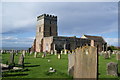
Early Medieval (Dark Age)Site Name: St Aidan's Church (Bamburgh)Country: England
NOTE: This site is 2.187 km away from the location you searched for.
County: Northumberland Type: Early Christian Sculptured Stone
Nearest Town: Bamburgh
Map Ref: NU1784334964
Latitude: 55.607959N Longitude: 1.718336W
Condition:
| 5 | Perfect |
| 4 | Almost Perfect |
| 3 | Reasonable but with some damage |
| 2 | Ruined but still recognisable as an ancient site |
| 1 | Pretty much destroyed, possibly visible as crop marks |
| 0 | No data. |
| -1 | Completely destroyed |
| 5 | Superb |
| 4 | Good |
| 3 | Ordinary |
| 2 | Not Good |
| 1 | Awful |
| 0 | No data. |
| 5 | Can be driven to, probably with disabled access |
| 4 | Short walk on a footpath |
| 3 | Requiring a bit more of a walk |
| 2 | A long walk |
| 1 | In the middle of nowhere, a nightmare to find |
| 0 | No data. |
| 5 | co-ordinates taken by GPS or official recorded co-ordinates |
| 4 | co-ordinates scaled from a detailed map |
| 3 | co-ordinates scaled from a bad map |
| 2 | co-ordinates of the nearest village |
| 1 | co-ordinates of the nearest town |
| 0 | no data |
Internal Links:
External Links:
I have visited· I would like to visit
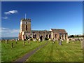
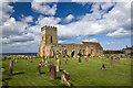
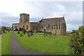
Anne T visited on 9th Oct 2018 - their rating: Cond: 3 Amb: 4 Access: 5 St Aidan's Church, Bamburgh: We hadn’t intended to visit this church, but having seen two wells located in the property immediately to its east, we decided to take a look before heading off to the castle. The church is open during daylight hours, and is very welcoming, with lights in the nave, chancel and sanctuary, and a great display of literature and guide books.
With this church being so old (there was a cell of St Aidan and a monastery on the site), I was surprised there was no remnant of a preaching cross or cross base. To ensure I didn’t miss anything, I picked up the laminated church guide and ran through the features. It mentioned a timber from the original church, placed in the ceiling above the font. The church was so dark at this point (right at the west end of the church) that I sought lights to illuminate the spot, and looking up, indeed there was a very large (cruck) timber.
The guide also mentioned two old tombstones in the churchyard which are said to be older than the present church. I found one, but not the other.
Grace Darling also has a memorial in the churchyard.
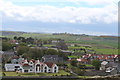
Walking down the eastern wall of the churchyard and looking over to the farm buildings beyond, we identified the sites of two wells marked on the 1860 OS map.
 (PID:186838)")
This church has associations with St Aidan and early Northumbrian history, and the Diocese of Newcastle Archaeological Assessment, March 2005, describes the church as "clearly a church of national significance."
Also recorded as Pastscape Monument No. 7624 and Historic England List ID 1042269. The Pastscape entry tells us this was orginally an Augustinina priory church built on the site of an Early Medieval church and cell of St Aidan.
Above the font, largely hidden in darkness, is a crucked timber, which is said to date from the original wooden church. The information in the church tells us: "(the original wooden church) was burnt down and rebuilt several times. All that remains is a forked beam which can now be seen in the ceiling above the font. Bede’s account of Aidan’s death describes him as leaning against a beam when he died, in a shelter built for him outside the church. With the beam surviving at least two fires it became an object of veneration and was through to have miraculous healing qualities. People came to touch it and even take bits away. Years later it was built into the baptistry to keep it out of reach!" To see this more clearly, seek out the light switches near the door at the base of the tower.
Against the northern wall of the chancel, at its western end, is a modern shrine to St Aidan, erected at the site where St Aidan was said to have died in 651. This shrine was dedicated by Archbishop Sentamu in 2013.
Whilst the links to St Aidan are certain, his associations with the crucked beam and the shrine are tenuous, but nevertheless lend a little 'magic' to this church.
Almost immediately to the east of the eastern churchyard wall, the 1860 map shows the site of two wells. Now no longer visible (the water is said to have dried up in summer months), the location of these wells is behind a barn. Because of their proximity to the church, they might be counted as holy wells, but the main well is to be found to the eastern end of the village green (see nearby sites below).
Also against the eastern wall of the churchyard, near the south eastern end of the sanctuary/crypt is a large rectangular grave slab which is said to be older then the present church; a second stone can also be found in the churchyard (we were unable to locate this).
Bamburgh is where Grace Darling lived and died, and there is a memorial to her in the church, her grave in the churchyard, and the RNLI Grace Darling Museum not far away in Radcliffe Road, Bamburgh, NE69 7AE.
You may be viewing yesterday's version of this page. To see the most up to date information please register for a free account.
 (PID:186839)")
 (PID:186837)")
 (PID:186836)")
Do not use the above information on other web sites or publications without permission of the contributor.
Nearby Images from Geograph Britain and Ireland:
©2010(licence)
©2013(licence)
©2013(licence)
©2013(licence)
©2013(licence)
The above images may not be of the site on this page, they are loaded from Geograph.
Please Submit an Image of this site or go out and take one for us!
Click here to see more info for this site
Nearby sites
Key: Red: member's photo, Blue: 3rd party photo, Yellow: other image, Green: no photo - please go there and take one, Grey: site destroyed
Download sites to:
KML (Google Earth)
GPX (GPS waypoints)
CSV (Garmin/Navman)
CSV (Excel)
To unlock full downloads you need to sign up as a Contributory Member. Otherwise downloads are limited to 50 sites.
Turn off the page maps and other distractions
Nearby sites listing. In the following links * = Image available
195m ESE 105° St Aidan's Well (Bamburgh)* Holy Well or Sacred Spring (NU1803234914)
297m SE 136° Leper's Well (Bamburgh)* Holy Well or Sacred Spring (NU18053475)
536m E 81° Bamburgh Castle* Sculptured Stone (NU1837335053)
745m SE 130° Bamburgh Barrow 1* Round Barrow(s) (NU1841634486)
849m ESE 113° Bamburgh Barrow 2* Round Barrow(s) (NU18633464)
2.8km WSW 248° Spindlestone Hill Fort* Hillfort (NU152339)
4.1km ENE 76° St. Cuthbert's Well (Farne Islands)* Holy Well or Sacred Spring (NU21783599)
4.6km SE 137° North Sunderland (Seahouses) Rock Art (NU2100031600)
4.8km SE 128° North Sunderland Cists* Cist (NU21603202)
5.3km SSW 209° St Hilda's Church (Lucker)* Ancient Cross (NU15303033)
5.5km SSW 200° Bradford Kaims Ancient Mine, Quarry or other Industry (NU16022980)
6.7km W 265° Belshill Quarry 1 & 2 Rock Art (NU1110034400)
7.2km SE 135° Beadnell Caravan Park Rock Art (NU2300029900)
8.4km SSE 153° Long Nanny* Standing Stone (Menhir) (NU21632748)
8.4km SE 136° Benthall Round Cairn* Cairn (NU2371528908)
8.5km NW 323° Lindisfarne Priory* Museum (NU12614172)
8.6km SSW 211° Isabella's Mount Camp Hillfort (NU13372757)
8.7km NW 325° Holy Island a & b Rock Art (NU1276042050)
8.7km SE 136° St Ebba's Chapel* Ancient Cross (NU2396428707)
9.1km SSE 158° Tughall Chapel* Ancient Cross (NU2132026540)
9.2km S 186° Ellingham a & d Rock Art (NU1691025790)
9.3km S 186° Ellingham b & c Rock Art (NU1686025750)
9.4km S 183° St Maurice's Well (Ellingham)* Holy Well or Sacred Spring (NU17452553)
9.6km W 262° Early Knowe Stone Circle (NU083336)
10.0km SSW 213° Lucker Moor 4 Rock Art (NU1245126497)
View more nearby sites and additional images


 We would like to know more about this location. Please feel free to add a brief description and any relevant information in your own language.
 Wir möchten mehr über diese Stätte erfahren. Bitte zögern Sie nicht, eine kurze Beschreibung und relevante Informationen in Deutsch hinzuzufügen.
 Nous aimerions en savoir encore un peu sur les lieux. S'il vous plaît n'hesitez pas à ajouter une courte description et tous les renseignements pertinents dans votre propre langue.
 Quisieramos informarnos un poco más de las lugares. No dude en añadir una breve descripción y otros datos relevantes en su propio idioma.