


<< Our Photo Pages >> Stow Camp - Hillfort in England in Gloucestershire
Submitted by 4clydesdale7 on Tuesday, 10 April 2012 Page Views: 5488
Iron Age and Later PrehistorySite Name: Stow Camp Alternative Name: Stow on the Wold CampCountry: England
NOTE: This site is 0.454 km away from the location you searched for.
County: Gloucestershire Type: Hillfort
Nearest Town: Stow on the Wold
Map Ref: SP19442595
Latitude: 51.931726N Longitude: 1.718673W
Condition:
| 5 | Perfect |
| 4 | Almost Perfect |
| 3 | Reasonable but with some damage |
| 2 | Ruined but still recognisable as an ancient site |
| 1 | Pretty much destroyed, possibly visible as crop marks |
| 0 | No data. |
| -1 | Completely destroyed |
| 5 | Superb |
| 4 | Good |
| 3 | Ordinary |
| 2 | Not Good |
| 1 | Awful |
| 0 | No data. |
| 5 | Can be driven to, probably with disabled access |
| 4 | Short walk on a footpath |
| 3 | Requiring a bit more of a walk |
| 2 | A long walk |
| 1 | In the middle of nowhere, a nightmare to find |
| 0 | No data. |
| 5 | co-ordinates taken by GPS or official recorded co-ordinates |
| 4 | co-ordinates scaled from a detailed map |
| 3 | co-ordinates scaled from a bad map |
| 2 | co-ordinates of the nearest village |
| 1 | co-ordinates of the nearest town |
| 0 | no data |
Internal Links:
External Links:
I have visited· I would like to visit
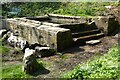
4clydesdale7 visited on 8th Apr 2012 - their rating: Cond: 2 Amb: 3 Access: 4 Another town site ravaged by modern development - the wells to the NE seem interesting
")
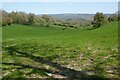
The hillfort commands the NE entrance to Stow on the Wold just to the east of the Fosse Way but as often happens near a town the Camp has suffered the ravages of town expansion development over time (the most recent being a Doctors' Surgery!) - although its NE earthworks are readily and prominently visible the remainder (forming the NE quadrant of the town) has been built upon for over 200 years - the Camp is celebrated with its name being used for roads etc
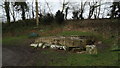
All three of the Ancient Wells of Stow lie slightly further NE (outside the single 3m high bank) - far quieter than the remaining parts of Stow in the packed summer tourist season - the Romans built a Villa on the West side of the Fosse Way
You may be viewing yesterday's version of this page. To see the most up to date information please register for a free account.
")
Do not use the above information on other web sites or publications without permission of the contributor.
Nearby Images from Geograph Britain and Ireland:
©2023(licence)
©2010(licence)
©2006(licence)
©2018(licence)
©2023(licence)
The above images may not be of the site on this page, they are loaded from Geograph.
Please Submit an Image of this site or go out and take one for us!
Click here to see more info for this site
Nearby sites
Key: Red: member's photo, Blue: 3rd party photo, Yellow: other image, Green: no photo - please go there and take one, Grey: site destroyed
Download sites to:
KML (Google Earth)
GPX (GPS waypoints)
CSV (Garmin/Navman)
CSV (Excel)
To unlock full downloads you need to sign up as a Contributory Member. Otherwise downloads are limited to 50 sites.
Turn off the page maps and other distractions
Nearby sites listing. In the following links * = Image available
156m NW 305° St Edwards (Stow Well) Well* Holy Well or Sacred Spring (SP1931126039)
1.1km NNW 342° Broadwell Chambered Tomb (SP191270)
1.5km SSW 193° St Edwards well* Holy Well or Sacred Spring (SP191245)
1.7km W 265° Our Lady's Well (near Stow)* Holy Well or Sacred Spring (SP177258)
2.1km W 260° Whittlestone* Standing Stone (Menhir) (SP174256)
2.3km WNW 284° Poles Wood East* Long Barrow (SP172265)
2.4km W 267° Lower Swell barrow* Chambered Tomb (SP17032580)
2.5km WNW 285° Pole's Wood West* Chambered Tomb (SP170266)
2.6km WSW 247° The Horestone (Lower Swell)* Standing Stone (Menhir) (SP170249)
2.7km W 279° Poles Wood South* Long Barrow (SP16732636)
2.8km W 269° The Tump* Round Barrow(s) (SP166259)
2.9km SSE 162° Icomb Camp* Hillfort (SP20352315)
3.6km NW 326° Ganborough* Chambered Tomb (SP174289)
3.7km W 263° Condicote Lane Chambered Tomb (SP158255)
4.7km WNW 301° Condicote henge* Henge (SP15392837)
4.9km WNW 299° Cross Well (Condicote)* Holy Well or Sacred Spring (SP15122827)
5.1km W 269° Eyeford Chambered Cairn (SP143258)
5.1km W 267° New Close Chambered Tomb (SP143257)
5.2km S 172° Wyck Beacon bowl barrow* Round Barrow(s) (SP20182078)
5.3km W 276° Swell Wold round barrow* Round Barrow(s) (SP14132648)
5.5km SSW 201° Salmonsbury Camp* Hillfort (SP175208)
6.0km W 276° Cow Common Long Barrow* Chambered Cairn (SP135266)
6.2km W 273° Cow Common Barrow Cemetery* Barrow Cemetery (SP132263)
6.3km ENE 69° Adlestrop Hill (round) Round Barrow(s) (SP253282)
6.3km ENE 69° Adlestrop Hill* Long Barrow (SP25362827)
View more nearby sites and additional images


 We would like to know more about this location. Please feel free to add a brief description and any relevant information in your own language.
 Wir möchten mehr über diese Stätte erfahren. Bitte zögern Sie nicht, eine kurze Beschreibung und relevante Informationen in Deutsch hinzuzufügen.
 Nous aimerions en savoir encore un peu sur les lieux. S'il vous plaît n'hesitez pas à ajouter une courte description et tous les renseignements pertinents dans votre propre langue.
 Quisieramos informarnos un poco más de las lugares. No dude en añadir una breve descripción y otros datos relevantes en su propio idioma.