


<< Text Pages >> Dewley Burn - Artificial Mound in England in Tyne and Wear
Submitted by Anonymous on Tuesday, 03 August 2021 Page Views: 530
Natural PlacesSite Name: Dewley BurnCountry: England
NOTE: This site is 3.453 km away from the location you searched for.
County: Tyne and Wear Type: Artificial Mound
Map Ref: NZ1601868016
Latitude: 55.006454N Longitude: 1.751096W
Condition:
| 5 | Perfect |
| 4 | Almost Perfect |
| 3 | Reasonable but with some damage |
| 2 | Ruined but still recognisable as an ancient site |
| 1 | Pretty much destroyed, possibly visible as crop marks |
| 0 | No data. |
| -1 | Completely destroyed |
| 5 | Superb |
| 4 | Good |
| 3 | Ordinary |
| 2 | Not Good |
| 1 | Awful |
| 0 | No data. |
| 5 | Can be driven to, probably with disabled access |
| 4 | Short walk on a footpath |
| 3 | Requiring a bit more of a walk |
| 2 | A long walk |
| 1 | In the middle of nowhere, a nightmare to find |
| 0 | No data. |
| 5 | co-ordinates taken by GPS or official recorded co-ordinates |
| 4 | co-ordinates scaled from a detailed map |
| 3 | co-ordinates scaled from a bad map |
| 2 | co-ordinates of the nearest village |
| 1 | co-ordinates of the nearest town |
| 0 | no data |
Internal Links:
External Links:
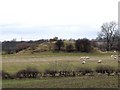
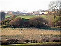
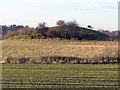
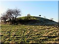
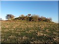
Dewley Hill is a Scheduled Monument and was considered to be a Bronze Age burial mound (marked as a Tumulus on old maps). The mound was, when visited by the OS in 1978, over 40m wide and 4m high and is more prosaically identified by English Heritage as a kaim (or kame), a sand and gravel mound of natural glacial origin. However, Mesolithic flints and a Neolithic stone axe found on the hill suggesting that the site was indeed known and used in prehistory.
You may be viewing yesterday's version of this page. To see the most up to date information please register for a free account.
Do not use the above information on other web sites or publications without permission of the contributor.
Nearby Images from Geograph Britain and Ireland:
©2008(licence)
©2013(licence)
©2013(licence)
©2013(licence)
©2013(licence)
The above images may not be of the site on this page, they are loaded from Geograph.
Please Submit an Image of this site or go out and take one for us!
Click here to see more info for this site
Nearby sites
Key: Red: member's photo, Blue: 3rd party photo, Yellow: other image, Green: no photo - please go there and take one, Grey: site destroyed
Download sites to:
KML (Google Earth)
GPX (GPS waypoints)
CSV (Garmin/Navman)
CSV (Excel)
To unlock full downloads you need to sign up as a Contributory Member. Otherwise downloads are limited to 50 sites.
Turn off the page maps and other distractions
Nearby sites listing. In the following links * = Image available
738m N 7° Callerton Lane End cropmark Ancient Village or Settlement (NZ16106875)
1.8km SW 222° Throckley Bank Top Rock Art (NZ1482866677)
1.8km SW 222° Throckley Bank Portable Rock Art (NZ1482066670)
2.6km WSW 246° Hadrian's Wall (Heddon on the Wall)* Misc. Earthwork (NZ13616693)
2.9km WSW 247° St Andrew's Church (Heddon on the Wall)* Ancient Cross (NZ1338666892)
3.3km SSW 195° Ryton Motte or Tumulus* Artificial Mound (NZ15176483)
3.8km SSW 209° Ryton 3 Rock Art (NZ1420064700)
4.0km SSW 198° Ryton 1 Rock Art (NZ1480064170)
4.0km WSW 249° Houghton Camp, Heddon on the Hill* Ancient Village or Settlement (NZ12246657)
4.3km S 170° Stella enclosure Ancient Village or Settlement (NZ168638)
4.5km SW 222° Simmery Hill Cist, Clara Vale* Cist (NZ13026462)
4.7km SSW 196° The Ryton Stone Rock Art (NZ1475063500)
4.8km SSW 199° Ryton 2 Rock Art (NZ1450063500)
4.9km SSE 161° Summerhill Cists* Cist (NZ176634)
5.0km N 7° St Mary The Virgin (Ponteland)* Ancient Cross (NZ1658872956)
6.0km SW 216° Bradley Hall Dene Barrow Round Barrow(s) (NZ12536317)
6.0km SW 219° Bradley Hall Ice House Barrow Round Barrow(s) (NZ12236333)
6.4km S 190° Holy Well, Greenside* Holy Well or Sacred Spring (NZ14936170)
6.5km SSW 207° White Well, Greenside* Holy Well or Sacred Spring (NZ13036222)
6.9km SSE 153° Axwell Park Barrow* Round Barrow(s) (NZ19196188)
7.0km WSW 252° Croft's Well (Horsley)* Holy Well or Sacred Spring (NZ0939965821)
7.0km WSW 255° Horsley Hill Homestead* Ancient Village or Settlement (NZ09266624)
7.6km SSE 156° Dam Head enclosure Ancient Village or Settlement (NZ192611)
7.7km ESE 123° Elswick Road Cist Cist (NZ225639)
7.8km SSE 162° Copers Wood earthwork, Winlaton Mill* Ancient Village or Settlement (NZ18456061)
View more nearby sites and additional images


 We would like to know more about this location. Please feel free to add a brief description and any relevant information in your own language.
 Wir möchten mehr über diese Stätte erfahren. Bitte zögern Sie nicht, eine kurze Beschreibung und relevante Informationen in Deutsch hinzuzufügen.
 Nous aimerions en savoir encore un peu sur les lieux. S'il vous plaît n'hesitez pas à ajouter une courte description et tous les renseignements pertinents dans votre propre langue.
 Quisieramos informarnos un poco más de las lugares. No dude en añadir una breve descripción y otros datos relevantes en su propio idioma.