


<< Our Photo Pages >> Hoon mount platformed bowl barrow - Round Barrow(s) in England in Derbyshire
Submitted by elad13 on Tuesday, 03 May 2022 Page Views: 823
Neolithic and Bronze AgeSite Name: Hoon mount platformed bowl barrowCountry: England
NOTE: This site is 2.955 km away from the location you searched for.
County: Derbyshire Type: Round Barrow(s)
Nearest Town: Derby Nearest Village: Hatton
Map Ref: SK23003182
Latitude: 52.883353N Longitude: 1.659655W
Condition:
| 5 | Perfect |
| 4 | Almost Perfect |
| 3 | Reasonable but with some damage |
| 2 | Ruined but still recognisable as an ancient site |
| 1 | Pretty much destroyed, possibly visible as crop marks |
| 0 | No data. |
| -1 | Completely destroyed |
| 5 | Superb |
| 4 | Good |
| 3 | Ordinary |
| 2 | Not Good |
| 1 | Awful |
| 0 | No data. |
| 5 | Can be driven to, probably with disabled access |
| 4 | Short walk on a footpath |
| 3 | Requiring a bit more of a walk |
| 2 | A long walk |
| 1 | In the middle of nowhere, a nightmare to find |
| 0 | No data. |
| 5 | co-ordinates taken by GPS or official recorded co-ordinates |
| 4 | co-ordinates scaled from a detailed map |
| 3 | co-ordinates scaled from a bad map |
| 2 | co-ordinates of the nearest village |
| 1 | co-ordinates of the nearest town |
| 0 | no data |
Internal Links:
External Links:
")
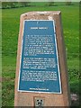
Plaque inscription on Trig point
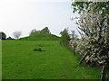
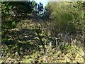
Is the only obvious survival from the group of barrows (burial mounds) which gave Hoon its name, derived from the word "haugum" meaning "at the barrows". No excavations of this well-prepared barrow are recorded and it is uncertain to which period of history it belongs. It may belong to the Late Bronze Age c2400-1500BC, or it may be an example of the much rarer Anglo Saxon or Viking burial mounds of the 7th-9th centuries AD.
As with South Derbyshire's other important collections of barrows at Ingleby and Swarkestone, Hoon Mount is deliberately situated on a prominent vantage point. It is likely that it was constructed for the burial of a single important person, but later "secondary" interments often followed.
Across the valley to the south west you will see the ruins of Tutbury Castle, which was held for the King in the Civil War and surrendered in April 1646 after a siege by Sir John Gell. The Arts and Crafts style house close at hand to the south east is known as Hoon Ridge built in 1907 for E.A.J. Maynard JP.
South Derbyshire District Council, 2001
You may be viewing yesterday's version of this page. To see the most up to date information please register for a free account.
")
Do not use the above information on other web sites or publications without permission of the contributor.
Nearby Images from Geograph Britain and Ireland:
©2008(licence)
©2008(licence)
©2008(licence)
©2018(licence)
©2018(licence)
The above images may not be of the site on this page, they are loaded from Geograph.
Please Submit an Image of this site or go out and take one for us!
Click here to see more info for this site
Nearby sites
Key: Red: member's photo, Blue: 3rd party photo, Yellow: other image, Green: no photo - please go there and take one, Grey: site destroyed
Download sites to:
KML (Google Earth)
GPX (GPS waypoints)
CSV (Garmin/Navman)
CSV (Excel)
To unlock full downloads you need to sign up as a Contributory Member. Otherwise downloads are limited to 50 sites.
Turn off the page maps and other distractions
Nearby sites listing. In the following links * = Image available
3.1km ESE 106° Etta's Well Holy Well or Sacred Spring (SK2631)
4.1km S 173° St Mary (Rolleston on Dove)* Ancient Cross (SK23542771)
8.0km SE 127° St Ann's Well (Repton)* Holy Well or Sacred Spring (SK29442699)
8.3km SE 125° St Thomas' Well (Repton) Holy Well or Sacred Spring (SK29822713)
8.5km NW 325° Bently Fields Farm* Modern Stone Circle etc (SK18093878)
8.6km ESE 123° St Wystan's (Repton)* Early Christian Sculptured Stone (SK30292717)
8.9km ESE 111° Findern Cursus Cursus (SK314287)
9.1km SSW 204° Wishing Well (nr Tatenhill) Holy Well or Sacred Spring (SK19272346)
9.3km ESE 108° Findern Cursus Cursus (SK319289)
9.4km SSE 167° St Andrew's Well (Burton on Trent)* Holy Well or Sacred Spring (SK25212266)
9.7km N 9° All Saints (Brailsford)* Ancient Cross (SK244414)
9.8km SSW 195° Holy Well (Tatenhill)* Holy Well or Sacred Spring (SK20572236)
9.9km NNE 14° The Brailsford Cross* Ancient Cross (SK253415)
10.9km ESE 109° Round Hill Barrow* Round Barrow(s) (SK33342832)
11.8km ESE 113° Anchor Church* Cave or Rock Shelter (SK3390827236)
12.0km WNW 282° St. Cuthbert's Well (Doveridge)* Holy Well or Sacred Spring (SK112342)
12.7km ESE 118° Heath Wood, Ingleby* Artificial Mound (SK34222591)
12.8km W 270° Toot Hill Barrow (2)* Round Barrow(s) (SK10143184)
12.8km ENE 70° Derby Museum and Art Gallery* Museum (SK3509236220)
12.9km ESE 121° Hangman's Stone (Ingleby)* Marker Stone (SK34162524)
13.0km ENE 67° Little Chester Roman Wells* Holy Well or Sacred Spring (SK350369)
13.2km ENE 67° Saint Alkmund's Well* Holy Well or Sacred Spring (SK35173703)
13.4km NNW 339° Wyaston Road 1* Round Barrow(s) (SK181443)
13.5km W 274° Maiden's Well* Holy Well or Sacred Spring (SK09493264)
13.7km E 100° Swarkestone Lows* Barrow Cemetery (SK365295)
View more nearby sites and additional images


 We would like to know more about this location. Please feel free to add a brief description and any relevant information in your own language.
 Wir möchten mehr über diese Stätte erfahren. Bitte zögern Sie nicht, eine kurze Beschreibung und relevante Informationen in Deutsch hinzuzufügen.
 Nous aimerions en savoir encore un peu sur les lieux. S'il vous plaît n'hesitez pas à ajouter une courte description et tous les renseignements pertinents dans votre propre langue.
 Quisieramos informarnos un poco más de las lugares. No dude en añadir una breve descripción y otros datos relevantes en su propio idioma.