


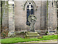
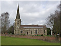
<< Our Photo Pages >> St Mary (Rolleston on Dove) - Ancient Cross in England in Staffordshire
Submitted by TimPrevett on Monday, 07 May 2007 Page Views: 6651
Early Medieval (Dark Age)Site Name: St Mary (Rolleston on Dove)Country: England
NOTE: This site is 2.707 km away from the location you searched for.
County: Staffordshire Type: Ancient Cross
Nearest Town: Rolleston on Dove
Map Ref: SK23542771
Latitude: 52.846385N Longitude: 1.651926W
Condition:
| 5 | Perfect |
| 4 | Almost Perfect |
| 3 | Reasonable but with some damage |
| 2 | Ruined but still recognisable as an ancient site |
| 1 | Pretty much destroyed, possibly visible as crop marks |
| 0 | No data. |
| -1 | Completely destroyed |
| 5 | Superb |
| 4 | Good |
| 3 | Ordinary |
| 2 | Not Good |
| 1 | Awful |
| 0 | No data. |
| 5 | Can be driven to, probably with disabled access |
| 4 | Short walk on a footpath |
| 3 | Requiring a bit more of a walk |
| 2 | A long walk |
| 1 | In the middle of nowhere, a nightmare to find |
| 0 | No data. |
| 5 | co-ordinates taken by GPS or official recorded co-ordinates |
| 4 | co-ordinates scaled from a detailed map |
| 3 | co-ordinates scaled from a bad map |
| 2 | co-ordinates of the nearest village |
| 1 | co-ordinates of the nearest town |
| 0 | no data |
Internal Links:
External Links:
I have visited· I would like to visit
BrownEdger elad13 would like to visit
 (PID:29918)")
9th Century Wheel Headed Cross
You may be viewing yesterday's version of this page. To see the most up to date information please register for a free account.
 (PID:29916)")
 (PID:29915)")
 (PID:29914)")
Do not use the above information on other web sites or publications without permission of the contributor.
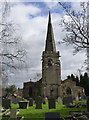
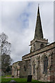
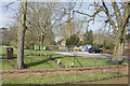
Nearby Images from Geograph Britain and Ireland:
©2014(licence)
©2014(licence)
©2014(licence)
©2018(licence)
©2014(licence)
The above images may not be of the site on this page, they are loaded from Geograph.
Please Submit an Image of this site or go out and take one for us!
Click here to see more info for this site
Nearby sites
Key: Red: member's photo, Blue: 3rd party photo, Yellow: other image, Green: no photo - please go there and take one, Grey: site destroyed
Download sites to:
KML (Google Earth)
GPX (GPS waypoints)
CSV (Garmin/Navman)
CSV (Excel)
To unlock full downloads you need to sign up as a Contributory Member. Otherwise downloads are limited to 50 sites.
Turn off the page maps and other distractions
Nearby sites listing. In the following links * = Image available
4.1km NE 37° Etta's Well Holy Well or Sacred Spring (SK2631)
4.1km N 353° Hoon mount platformed bowl barrow* Round Barrow(s) (SK23003182)
5.3km SSE 162° St Andrew's Well (Burton on Trent)* Holy Well or Sacred Spring (SK25212266)
5.9km E 97° St Ann's Well (Repton)* Holy Well or Sacred Spring (SK29442699)
6.0km SW 225° Wishing Well (nr Tatenhill) Holy Well or Sacred Spring (SK19272346)
6.1km SSW 209° Holy Well (Tatenhill)* Holy Well or Sacred Spring (SK20572236)
6.3km E 96° St Thomas' Well (Repton) Holy Well or Sacred Spring (SK29822713)
6.8km E 95° St Wystan's (Repton)* Early Christian Sculptured Stone (SK30292717)
7.9km E 83° Findern Cursus Cursus (SK314287)
8.4km E 82° Findern Cursus Cursus (SK319289)
9.8km E 87° Round Hill Barrow* Round Barrow(s) (SK33342832)
10.3km E 93° Anchor Church* Cave or Rock Shelter (SK3390827236)
10.8km E 100° Heath Wood, Ingleby* Artificial Mound (SK34222591)
10.9km ESE 103° Hangman's Stone (Ingleby)* Marker Stone (SK34162524)
11.2km SSW 201° Efflinch Cursus (SK19521724)
11.5km SSW 202° Barton Under Needwood Cursus Cursus (SK19301697)
11.7km SSW 200° Catholme 01* Timber Circle (SK19621666)
11.7km SSW 201° Catholme 02 Henge (SK19431670)
12.3km NNW 334° Bently Fields Farm* Modern Stone Circle etc (SK18093878)
13.0km E 82° Swarkestone Lows* Barrow Cemetery (SK365295)
13.5km SE 135° Blackfordby Spring* Holy Well or Sacred Spring (SK331182)
13.6km SE 142° Blackfordby Spring* Holy Well or Sacred Spring (SK3217)
13.7km N 4° All Saints (Brailsford)* Ancient Cross (SK244414)
13.9km N 8° The Brailsford Cross* Ancient Cross (SK253415)
13.9km WNW 298° St. Cuthbert's Well (Doveridge)* Holy Well or Sacred Spring (SK112342)
View more nearby sites and additional images


 We would like to know more about this location. Please feel free to add a brief description and any relevant information in your own language.
 Wir möchten mehr über diese Stätte erfahren. Bitte zögern Sie nicht, eine kurze Beschreibung und relevante Informationen in Deutsch hinzuzufügen.
 Nous aimerions en savoir encore un peu sur les lieux. S'il vous plaît n'hesitez pas à ajouter une courte description et tous les renseignements pertinents dans votre propre langue.
 Quisieramos informarnos un poco más de las lugares. No dude en añadir una breve descripción y otros datos relevantes en su propio idioma.