


<< Our Photo Pages >> All Saints Well - Holy Well or Sacred Spring in England in Hampshire
Submitted by DavidCWoods on Saturday, 18 December 2004 Page Views: 7502
Springs and Holy WellsSite Name: All Saints WellCountry: England
NOTE: This site is 4.247 km away from the location you searched for.
County: Hampshire Type: Holy Well or Sacred Spring
Nearest Town: Bournemouth Nearest Village: Thorney Hill
Map Ref: SZ197997
Latitude: 50.796532N Longitude: 1.721847W
Condition:
| 5 | Perfect |
| 4 | Almost Perfect |
| 3 | Reasonable but with some damage |
| 2 | Ruined but still recognisable as an ancient site |
| 1 | Pretty much destroyed, possibly visible as crop marks |
| 0 | No data. |
| -1 | Completely destroyed |
| 5 | Superb |
| 4 | Good |
| 3 | Ordinary |
| 2 | Not Good |
| 1 | Awful |
| 0 | No data. |
| 5 | Can be driven to, probably with disabled access |
| 4 | Short walk on a footpath |
| 3 | Requiring a bit more of a walk |
| 2 | A long walk |
| 1 | In the middle of nowhere, a nightmare to find |
| 0 | No data. |
| 5 | co-ordinates taken by GPS or official recorded co-ordinates |
| 4 | co-ordinates scaled from a detailed map |
| 3 | co-ordinates scaled from a bad map |
| 2 | co-ordinates of the nearest village |
| 1 | co-ordinates of the nearest town |
| 0 | no data |
Internal Links:
External Links:
")
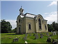
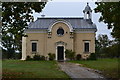
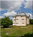
All Saints Church is only a couple of hundred years old, and has a strange, unchurch-like appearance. The well is among the graves, and although the church is comparatively recent there is a tumulus shown in the next field, although this was not seen.
You may be viewing yesterday's version of this page. To see the most up to date information please register for a free account.
Do not use the above information on other web sites or publications without permission of the contributor.
Nearby Images from Geograph Britain and Ireland:
©2012(licence)
©2012(licence)
©2012(licence)
©2018(licence)
©2010(licence)
The above images may not be of the site on this page, they are loaded from Geograph.
Please Submit an Image of this site or go out and take one for us!
Click here to see more info for this site
Nearby sites
Key: Red: member's photo, Blue: 3rd party photo, Yellow: other image, Green: no photo - please go there and take one, Grey: site destroyed
Download sites to:
KML (Google Earth)
GPX (GPS waypoints)
CSV (Garmin/Navman)
CSV (Excel)
To unlock full downloads you need to sign up as a Contributory Member. Otherwise downloads are limited to 50 sites.
Turn off the page maps and other distractions
Nearby sites listing. In the following links * = Image available
1.4km NNW 327° Lugden Barrow* Round Barrow(s) (SU18920091)
4.1km N 349° Strodgemoor Barrow* Round Barrow(s) (SU18910371)
4.2km N 3° Castle Hill (Hampshire)* Hillfort (SU199039)
4.4km NNW 344° Knaves Ash barrow* Round Barrow(s) (SU18430396)
4.6km N 11° St Mary's Well (Hampshire)* Holy Well or Sacred Spring (SU2056304175)
4.8km NE 52° Clay Hill tumuli* Round Barrow(s) (SU235027)
4.9km SW 235° St Michael's Well (Sopley)* Holy Well or Sacred Spring (SZ1573596865)
5.2km NNE 19° Collins Grave Round Barrow(s) (SU21350461)
6.8km ENE 59° Ferny Knap tumuli* Round Barrow(s) (SU255032)
6.8km SW 232° St Catherine's Hill (Christchurch)* Barrow Cemetery (SZ143955)
6.9km S 185° Friars Cliff Tumulus* Round Barrow(s) (SZ1917492825)
6.9km WSW 249° Sopley Common Tumulus* Round Barrow(s) (SZ132972)
7.1km WSW 247° Ramsdown Plantation / Sopley Common* Round Barrow(s) (SZ132969)
7.4km WNW 288° Barnsfield Heath (North)* Round Barrow(s) (SU127020)
7.4km W 267° Hurn Forest Barrow* Round Barrow(s) (SZ123993)
8.1km SSW 208° The Red House Museum* Museum (SZ1588292577)
8.1km E 90° Longslade View tumulus* Round Barrow(s) (SZ278998)
8.7km NW 311° Watchmoor Wood* Round Barrow(s) (SU131054)
9.1km NW 311° Ashley Heath* Round Barrow(s) (SU128057)
9.2km NNW 340° Moyles Court bowl barrow* Round Barrow(s) (SU16510833)
9.2km N 1° Castle Piece* Hillfort (SU199089)
9.2km SSW 200° Double Dykes Bowl Barrow* Round Barrow(s) (SZ16609102)
9.3km ENE 65° Ober Heath* Round Barrow(s) (SU281037)
9.3km NW 313° Bakers Hanging* Round Barrow(s) (SU128060)
9.3km SSW 195° Warren Hill Round Barrow 1 Round Barrow(s) (SZ17269069)
View more nearby sites and additional images


 We would like to know more about this location. Please feel free to add a brief description and any relevant information in your own language.
 Wir möchten mehr über diese Stätte erfahren. Bitte zögern Sie nicht, eine kurze Beschreibung und relevante Informationen in Deutsch hinzuzufügen.
 Nous aimerions en savoir encore un peu sur les lieux. S'il vous plaît n'hesitez pas à ajouter une courte description et tous les renseignements pertinents dans votre propre langue.
 Quisieramos informarnos un poco más de las lugares. No dude en añadir una breve descripción y otros datos relevantes en su propio idioma.