


<< Our Photo Pages >> Tughall Chapel - Ancient Cross in England in Northumberland
Submitted by Anne T on Tuesday, 22 May 2018 Page Views: 1496
Early Medieval (Dark Age)Site Name: Tughall ChapelCountry: England
NOTE: This site is 1.101 km away from the location you searched for.
County: Northumberland Type: Ancient Cross
Nearest Town: Seahouses Nearest Village: Tughall / Beadnell
Map Ref: NU2132026540
Latitude: 55.532129N Longitude: 1.663793W
Condition:
| 5 | Perfect |
| 4 | Almost Perfect |
| 3 | Reasonable but with some damage |
| 2 | Ruined but still recognisable as an ancient site |
| 1 | Pretty much destroyed, possibly visible as crop marks |
| 0 | No data. |
| -1 | Completely destroyed |
| 5 | Superb |
| 4 | Good |
| 3 | Ordinary |
| 2 | Not Good |
| 1 | Awful |
| 0 | No data. |
| 5 | Can be driven to, probably with disabled access |
| 4 | Short walk on a footpath |
| 3 | Requiring a bit more of a walk |
| 2 | A long walk |
| 1 | In the middle of nowhere, a nightmare to find |
| 0 | No data. |
| 5 | co-ordinates taken by GPS or official recorded co-ordinates |
| 4 | co-ordinates scaled from a detailed map |
| 3 | co-ordinates scaled from a bad map |
| 2 | co-ordinates of the nearest village |
| 1 | co-ordinates of the nearest town |
| 0 | no data |
Internal Links:
External Links:
I have visited· I would like to visit
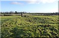
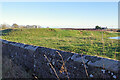
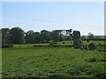
Anne T visited on 20th May 2018 - their rating: Cond: 2 Amb: 4 Access: 4 Socket stone and cross shaft fragment, Tughall: Continuing along the busy B1340 from the Long Nanny standing stone, we turned right off the road towards Tughall Farm. There, the remains of the chapel stood above the road. We parked at a small layby just off the main road at NU 21427 26478, where there was a small gate into the field. This had been wired shut, so we walked round to the main gate at NU 21224 26486. There was absolutely no-one around to ask, and as the cattle were at the far end of the field, we let ourselves in.
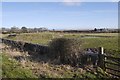
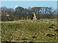
The chapel is raised above the surrounding land. Only the tiniest bit of masonry remains (part of the apse, according to HE). The cross base is to the south of the chapel, almost next to what we initially thought might have been a hogback, but is only an old grave stone. I couldn’t see any writing on it.
The portion of cross shaft fragment remaining in the socket stone is very small and thin. I wonder what happened to the rest of it? [Note, this is on private land, but we didn't find anyone around in all the buildings on the farm to ask if we could take a look.]
Next stop, but not recorded on the Portal, was the lime kilns and harbour at Beadnell (too recent in time!)
")
This now ruined chapel was "no doubt built on the spot where the body of St. Cuthbert rested on the night of 13th December 1069 during its removal from Durham to Lindisfarne." Originally having early Norman architecture, the chapel was mentioned in documents of 1292, when Edward 1 stayed at the village of Tughall on his way up to Scotland; subsequently in use up until 1630, the site was used as a burial place for some time after.
Built upon a raised mound 222m north east to south west and 10m north west to south east, the remains of a stone cross is located 10m to the south of the chapel, consisting of a socket stone 0.7m square and 0.1m high, with part of a cross shaft 0.2m high. Nearby is a complete grave cover measuring 2m long and 0.2m thick.
For more information see Pastscape Monument No. 8206 and Historic England List ID 1014732.
Please note this chapel and cross are located on private land.
You may be viewing yesterday's version of this page. To see the most up to date information please register for a free account.
")
")
")
")
Do not use the above information on other web sites or publications without permission of the contributor.
Nearby Images from Geograph Britain and Ireland:
©2014(licence)
©2023(licence)
©2017(licence)
©2017(licence)
©2006(licence)
The above images may not be of the site on this page, they are loaded from Geograph.
Please Submit an Image of this site or go out and take one for us!
Click here to see more info for this site
Nearby sites
Key: Red: member's photo, Blue: 3rd party photo, Yellow: other image, Green: no photo - please go there and take one, Grey: site destroyed
Download sites to:
KML (Google Earth)
GPX (GPS waypoints)
CSV (Garmin/Navman)
CSV (Excel)
To unlock full downloads you need to sign up as a Contributory Member. Otherwise downloads are limited to 50 sites.
Turn off the page maps and other distractions
Nearby sites listing. In the following links * = Image available
989m NNE 18° Long Nanny* Standing Stone (Menhir) (NU21632748)
3.4km NE 46° Benthall Round Cairn* Cairn (NU2371528908)
3.4km NE 51° St Ebba's Chapel* Ancient Cross (NU2396428707)
3.8km NNE 27° Beadnell Caravan Park Rock Art (NU2300029900)
4.0km WSW 256° St Maurice's Well (Ellingham)* Holy Well or Sacred Spring (NU17452553)
4.5km W 261° Ellingham a & d Rock Art (NU1691025790)
4.5km W 260° Ellingham b & c Rock Art (NU1686025750)
5.1km N 357° North Sunderland (Seahouses) Rock Art (NU2100031600)
5.5km N 3° North Sunderland Cists* Cist (NU21603202)
6.2km WNW 302° Bradford Kaims Ancient Mine, Quarry or other Industry (NU16022980)
6.4km SE 137° Dunstanburgh Castle* Promontory Fort / Cliff Castle (NU2571821930)
7.1km WNW 303° St Hilda's Church (Lucker)* Ancient Cross (NU15303033)
7.6km W 260° Wandylaw G Rock Art (NU1380125116)
7.6km W 259° Wandylaw C* Rock Art (NU1381225059)
7.6km W 259° Wandylaw F* Rock Art (NU1380325081)
7.6km W 259° Wandylaw B Rock Art (NU1379525109)
7.6km W 259° Wandylaw E* Rock Art (NU1379425109)
7.6km W 260° Wandylaw D Rock Art (NU1379325112)
7.6km W 259° Wandylaw A* Rock Art (NU1379925064)
8.0km W 278° Isabella's Mount Camp Hillfort (NU13372757)
8.5km NNW 340° Bamburgh Barrow 1* Round Barrow(s) (NU1841634486)
8.5km NNW 342° Bamburgh Barrow 2* Round Barrow(s) (NU18633464)
8.8km NNW 339° Leper's Well (Bamburgh)* Holy Well or Sacred Spring (NU18053475)
8.8km W 270° Lucker Moor 4 Rock Art (NU1245126497)
9.0km NNW 339° St Aidan's Well (Bamburgh)* Holy Well or Sacred Spring (NU1803234914)
View more nearby sites and additional images


 We would like to know more about this location. Please feel free to add a brief description and any relevant information in your own language.
 Wir möchten mehr über diese Stätte erfahren. Bitte zögern Sie nicht, eine kurze Beschreibung und relevante Informationen in Deutsch hinzuzufügen.
 Nous aimerions en savoir encore un peu sur les lieux. S'il vous plaît n'hesitez pas à ajouter une courte description et tous les renseignements pertinents dans votre propre langue.
 Quisieramos informarnos un poco más de las lugares. No dude en añadir una breve descripción y otros datos relevantes en su propio idioma.