


<< Our Photo Pages >> Longslade View tumulus - Round Barrow(s) in England in Hampshire
Submitted by JimChampion on Sunday, 06 May 2007 Page Views: 8238
Neolithic and Bronze AgeSite Name: Longslade View tumulusCountry: England
NOTE: This site is 4.873 km away from the location you searched for.
County: Hampshire Type: Round Barrow(s)
Nearest Village: Sway
Map Ref: SZ278998
Latitude: 50.797101N Longitude: 1.606913W
Condition:
| 5 | Perfect |
| 4 | Almost Perfect |
| 3 | Reasonable but with some damage |
| 2 | Ruined but still recognisable as an ancient site |
| 1 | Pretty much destroyed, possibly visible as crop marks |
| 0 | No data. |
| -1 | Completely destroyed |
| 5 | Superb |
| 4 | Good |
| 3 | Ordinary |
| 2 | Not Good |
| 1 | Awful |
| 0 | No data. |
| 5 | Can be driven to, probably with disabled access |
| 4 | Short walk on a footpath |
| 3 | Requiring a bit more of a walk |
| 2 | A long walk |
| 1 | In the middle of nowhere, a nightmare to find |
| 0 | No data. |
| 5 | co-ordinates taken by GPS or official recorded co-ordinates |
| 4 | co-ordinates scaled from a detailed map |
| 3 | co-ordinates scaled from a bad map |
| 2 | co-ordinates of the nearest village |
| 1 | co-ordinates of the nearest town |
| 0 | no data |
Internal Links:
External Links:
I have visited· I would like to visit
JimChampion has visited here
")
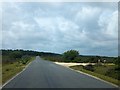
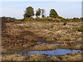
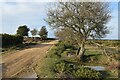
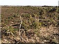
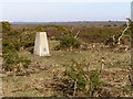
This 25 metre diameter bowl barrow is in a prominent position on an east-west heathland ridge, to the north of Sway in the New Forest. A gravel track to the Longslade View car park has cut across the right hand side of the barrow, which is now overgrown with gorse and small trees.
You may be viewing yesterday's version of this page. To see the most up to date information please register for a free account.
")
Do not use the above information on other web sites or publications without permission of the contributor.
coldrum has found this location on Google Street View:
Nearby Images from Geograph Britain and Ireland:
©2012(licence)
©2007(licence)
©2022(licence)
©2007(licence)
©2007(licence)
The above images may not be of the site on this page, they are loaded from Geograph.
Please Submit an Image of this site or go out and take one for us!
Click here to see more info for this site
Nearby sites
Key: Red: member's photo, Blue: 3rd party photo, Yellow: other image, Green: no photo - please go there and take one, Grey: site destroyed
Download sites to:
KML (Google Earth)
GPX (GPS waypoints)
CSV (Garmin/Navman)
CSV (Excel)
To unlock full downloads you need to sign up as a Contributory Member. Otherwise downloads are limited to 50 sites.
Turn off the page maps and other distractions
Nearby sites listing. In the following links * = Image available
1.8km E 83° Setley Plain disc barrows* Round Barrow(s) (SU29620002)
2.1km SE 128° Shirley Holms* Round Barrow(s) (SZ295985)
3.9km N 5° Ober Heath* Round Barrow(s) (SU281037)
4.1km NNW 326° Ferny Knap tumuli* Round Barrow(s) (SU255032)
4.8km SE 129° Buckland Rings* Ancient Village or Settlement (SZ315968)
5.2km NW 304° Clay Hill tumuli* Round Barrow(s) (SU235027)
6.1km ENE 71° Pudding Barrow* Round Barrow(s) (SU336018)
6.2km E 88° Beaulieu Heath (West)* Round Barrow(s) (SU3400)
6.3km E 94° Laurences Barrow* Round Barrow(s) (SZ34139937)
8.0km NW 307° Collins Grave Round Barrow(s) (SU21350461)
8.1km W 270° All Saints Well* Holy Well or Sacred Spring (SZ197997)
8.4km WNW 302° St Mary's Well (Hampshire)* Holy Well or Sacred Spring (SU2056304175)
8.6km NNE 15° New Forest Museum* Museum (SU30020813)
8.9km WNW 298° Castle Hill (Hampshire)* Hillfort (SU199039)
8.9km W 277° Lugden Barrow* Round Barrow(s) (SU18920091)
9.7km WNW 294° Strodgemoor Barrow* Round Barrow(s) (SU18910371)
10.2km NE 35° Matley Heath* Round Barrow(s) (SU336082)
10.2km WNW 294° Knaves Ash barrow* Round Barrow(s) (SU18430396)
10.4km NE 34° Ashurst Lodge Earthworks* Misc. Earthwork (SU336085)
10.5km NE 50° Yew Tree Heath* Round Barrow(s) (SU3589506556)
10.8km ENE 64° Culverley Farm Bowl Barrow Round Barrow(s) (SU37530461)
11.1km SW 231° Friars Cliff Tumulus* Round Barrow(s) (SZ1917492825)
12.0km NE 45° Longdown (New Forest) tumuli* Round Barrow(s) (SU363083)
12.0km NW 319° Castle Piece* Hillfort (SU199089)
12.3km N 0° Malwood Castle Hillfort (SU278121)
View more nearby sites and additional images


 We would like to know more about this location. Please feel free to add a brief description and any relevant information in your own language.
 Wir möchten mehr über diese Stätte erfahren. Bitte zögern Sie nicht, eine kurze Beschreibung und relevante Informationen in Deutsch hinzuzufügen.
 Nous aimerions en savoir encore un peu sur les lieux. S'il vous plaît n'hesitez pas à ajouter une courte description et tous les renseignements pertinents dans votre propre langue.
 Quisieramos informarnos un poco más de las lugares. No dude en añadir una breve descripción y otros datos relevantes en su propio idioma.