

<< Our Photo Pages >> St. Mary's Well (Jesmond) - Holy Well or Sacred Spring in England in Tyne and Wear
Submitted by SolarMegalith on Monday, 08 August 2016 Page Views: 5327
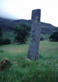
Springs and Holy WellsSite Name: St. Mary's Well (Jesmond)Country: England
NOTE: This site is 1.933 km away from the location you searched for.
County: Tyne and Wear Type: Holy Well or Sacred Spring
Nearest Town: Newcastle
Map Ref: NZ2584366508
Latitude: 54.992492N Longitude: 1.597623W
Condition:
| 5 | Perfect |
| 4 | Almost Perfect |
| 3 | Reasonable but with some damage |
| 2 | Ruined but still recognisable as an ancient site |
| 1 | Pretty much destroyed, possibly visible as crop marks |
| 0 | No data. |
| -1 | Completely destroyed |
| 5 | Superb |
| 4 | Good |
| 3 | Ordinary |
| 2 | Not Good |
| 1 | Awful |
| 0 | No data. |
| 5 | Can be driven to, probably with disabled access |
| 4 | Short walk on a footpath |
| 3 | Requiring a bit more of a walk |
| 2 | A long walk |
| 1 | In the middle of nowhere, a nightmare to find |
| 0 | No data. |
| 5 | co-ordinates taken by GPS or official recorded co-ordinates |
| 4 | co-ordinates scaled from a detailed map |
| 3 | co-ordinates scaled from a bad map |
| 2 | co-ordinates of the nearest village |
| 1 | co-ordinates of the nearest town |
| 0 | no data |
Internal Links:
External Links:
I have visited· I would like to visit
Anne T visited on 23rd Apr 2017 - their rating: Cond: 4 Amb: 4 Access: 4 St. Mary's Well, Jesmond: From the elusive (non-existent!) Axwell Park Tumulus, we headed off down the Coast Road to Jesmond to find this well. It was a delight – an oasis in the midst of the city.
Parking on Jesmond Dene Road where it meet Grosvenor Avenue, we headed west up The Grove – a shady footpath that runs between The Grove and Red Park Road, in between the back gardens of the houses.
We found the gate to this well to our right hand side, several hundred metres up the path, highlighted by the blue signpost.
Descending into this shady nook, down the stone steps, the first view of the well was of the small statues, tea-lights and mementos left on top of the well covering. As my eyes adapted to the shade, the pool of the well came into view.
The well was full of water, with a steady flow over the cobbles towards the pool. There was a cute copper jug left attached to the side of the well, which I took off and dunked into the water. Andrew and I both tasted the water, and it was completely tasteless, which was a surprise.
After enjoying the peace and calm, we headed off to find St. Mary’s Chapel, now ruined, just down the road. Really enjoyed this visit.
SolarMegalith visited on 6th Aug 2016 - their rating: Cond: 4 Amb: 5 Access: 4
Average ratings for this site from all visit loggers: Condition: 4 Ambience: 4.5 Access: 4
 (PID:156334)")
St. Mary's Well is traditionally considered a holy well, but it is probably no earlier than the 17th century. Its structure was remodelled in the 19th century. The well is located next to probable pilgrim's way leading to the nearby St. Mary's Chapel in Jesmond.
You may be viewing yesterday's version of this page. To see the most up to date information please register for a free account.
 (PID:165031)")
 (PID:165030)")
 (PID:165029)")
 (PID:165028)")
 (PID:156333)")
 (PID:156332)")
 (PID:156331)")
 (PID:156330)")
Do not use the above information on other web sites or publications without permission of the contributor.
Click here to see more info for this site
Nearby sites
Key: Red: member's photo, Blue: 3rd party photo, Yellow: other image, Green: no photo - please go there and take one, Grey: site destroyed
Download sites to:
KML (Google Earth)
GPX (GPS waypoints)
CSV (Garmin/Navman)
CSV (Excel)
To unlock full downloads you need to sign up as a Contributory Member. Otherwise downloads are limited to 50 sites.
Turn off the page maps and other distractions
Nearby sites listing. In the following links * = Image available
901m S 170° Villa Reale cist, Jesmond* Cist (NZ26006562)
1.4km SW 232° Exhibition Park Circle* Modern Stone Circle etc (NZ2476265651)
1.7km SW 217° Great North Museum* Museum (NZ2485565168)
1.7km SW 217° Great North Museum (Rock Art)* Museum (NZ2485365162)
1.7km SW 217° Great North Museum (Anglo Saxon Stones)* Museum (NZ2485065160)
1.7km SW 218° The Ponteland Boulder* Rock Art (NZ24816518)
1.9km SW 222° The Museum of Antiquities* Museum (NZ246651)
2.5km SSW 212° St Andrew's Church (Gallowgate)* Early Christian Sculptured Stone (NZ2453564409)
2.6km SSW 210° White Cross (Newcastle)* Ancient Cross (NZ24586426)
2.6km SSW 199° St Nicholas's Cathedral (Newcastle)* Ancient Cross (NZ2498664008)
2.7km SSW 194° Cale Cross (Newcastle)* Ancient Cross (NZ25206392)
3.0km SSW 199° White Friar Tower Cist Cist (NZ24876368)
4.2km SW 232° Elswick Road Cist Cist (NZ225639)
5.5km NNW 333° Hazlerigg cropmark (South) Ancient Village or Settlement (NZ23327140)
5.7km NNW 336° Hazlerigg cropmark (North) Ancient Village or Settlement (NZ23467172)
6.0km NE 46° Holy Stone (North Tyneside)* Ancient Cross (NZ30137066)
6.6km ESE 111° Bede's Well Holy Well or Sacred Spring (NZ31986415)
7.8km SW 216° Marshall Lands enclosure Ancient Village or Settlement (NZ213602)
8.0km SSW 200° Ravensworth enclosure Ancient Village or Settlement (NZ232590)
8.0km E 98° Bede's World (Jarrow)* Ancient Cross (NZ33756542)
8.1km SW 235° Axwell Park Barrow* Round Barrow(s) (NZ19196188)
8.1km E 99° Jarrow* Ancient Cross (NZ3387965216)
8.5km SW 231° Dam Head enclosure Ancient Village or Settlement (NZ192611)
8.8km WSW 250° Summerhill Cists* Cist (NZ176634)
9.1km NNW 328° Gardener's house crop mark, Dinnington Ancient Village or Settlement (NZ20977420)
View more nearby sites and additional images


 We would like to know more about this location. Please feel free to add a brief description and any relevant information in your own language.
 Wir möchten mehr über diese Stätte erfahren. Bitte zögern Sie nicht, eine kurze Beschreibung und relevante Informationen in Deutsch hinzuzufügen.
 Nous aimerions en savoir encore un peu sur les lieux. S'il vous plaît n'hesitez pas à ajouter une courte description et tous les renseignements pertinents dans votre propre langue.
 Quisieramos informarnos un poco más de las lugares. No dude en añadir una breve descripción y otros datos relevantes en su propio idioma.