


<< Our Photo Pages >> Adel Cupstone - Rock Art in England
Submitted by DavidRaven on Thursday, 11 December 2003 Page Views: 10575
Rock ArtSite Name: Adel CupstoneCountry: England
NOTE: This site is 2.592 km away from the location you searched for.
Type: Rock Art
Nearest Town: Bramhope Nearest Village: Adel
Map Ref: SE274402 Landranger Map Number: 104
Latitude: 53.857308N Longitude: 1.584914W
Condition:
| 5 | Perfect |
| 4 | Almost Perfect |
| 3 | Reasonable but with some damage |
| 2 | Ruined but still recognisable as an ancient site |
| 1 | Pretty much destroyed, possibly visible as crop marks |
| 0 | No data. |
| -1 | Completely destroyed |
| 5 | Superb |
| 4 | Good |
| 3 | Ordinary |
| 2 | Not Good |
| 1 | Awful |
| 0 | No data. |
| 5 | Can be driven to, probably with disabled access |
| 4 | Short walk on a footpath |
| 3 | Requiring a bit more of a walk |
| 2 | A long walk |
| 1 | In the middle of nowhere, a nightmare to find |
| 0 | No data. |
| 5 | co-ordinates taken by GPS or official recorded co-ordinates |
| 4 | co-ordinates scaled from a detailed map |
| 3 | co-ordinates scaled from a bad map |
| 2 | co-ordinates of the nearest village |
| 1 | co-ordinates of the nearest town |
| 0 | no data |
Internal Links:
External Links:
I have visited· I would like to visit
SumDoood would like to visit
")
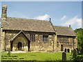
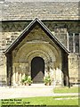
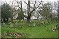
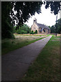
Thought to be the base of a lost stone cross, it now sits amongst old stone coffins in Adel churchyard (SE 2739 4020). The rock has been shaped into a vague cylinder with a basin and undercut below. There are said to be six cups and a 'horseshoe' groove on the upper surface (two of the cups are partly cut away by the edge of the stone). It is believed to have originated from the nearby village of Eccup (Simpson, 1879) and could be the remains of a 'plague stone' (Cowling, 1963).
You may be viewing yesterday's version of this page. To see the most up to date information please register for a free account.
Do not use the above information on other web sites or publications without permission of the contributor.
Nearby Images from Geograph Britain and Ireland:
©2005(licence)
©2006(licence)
©2008(licence)
©2016(licence)
©2012(licence)
The above images may not be of the site on this page, they are loaded from Geograph.
Please Submit an Image of this site or go out and take one for us!
Click here to see more info for this site
Nearby sites
Key: Red: member's photo, Blue: 3rd party photo, Yellow: other image, Green: no photo - please go there and take one, Grey: site destroyed
Download sites to:
KML (Google Earth)
GPX (GPS waypoints)
CSV (Garmin/Navman)
CSV (Excel)
To unlock full downloads you need to sign up as a Contributory Member. Otherwise downloads are limited to 50 sites.
Turn off the page maps and other distractions
Nearby sites listing. In the following links * = Image available
2.6km WNW 293° Long Stone (Adel) Standing Stone (Menhir) (SE25014119)
4.9km WSW 237° Horsforth Milestone* Rock Art (SE23323748)
5.0km NE 55° Grey Stone (Harewood)* Rock Art (SE31474308)
6.1km SSE 168° Gray Stone (Burley) Natural Stone / Erratic / Other Natural Feature (SE2865934229)
6.3km SE 125° Gipton Wood Ancient Village or Settlement (SE32653664)
7.2km SSE 154° Lady Well (Leeds) Holy Well or Sacred Spring (SE30603373)
7.2km WSW 246° St Wilfrid (Calverley) Sculptured Stone (SE208372)
7.4km WSW 252° Calverley Woods 2 (Leeds) Rock Art (SE2037737939)
7.4km WSW 252° Calverley Woods 3 (Leeds)* Rock Art (SE2036937923)
7.5km SSE 152° Quarry Hill (Leeds) Ancient Village or Settlement (SE309336)
7.5km WNW 296° Bull Stone (Guiseley) Standing Stone (Menhir) (SE2067043481)
7.5km WNW 296° Bull Stone* Standing Stone (Menhir) (SE206435)
7.6km SSE 164° St Helen's Well (Holbeck) Holy Well or Sacred Spring (SE295329)
7.6km SSE 155° St Peter's Minster Church (Kirkgate) Ancient Cross (SE30653330)
7.6km WSW 253° Calverley Woods 1 (Leeds) Rock Art (SE20083791)
7.7km WNW 301° Knotties Stone (Otley Chevin)* Rock Art (SE2077144182)
8.0km WSW 247° Calverley Woods Stone Circle (Leeds) Stone Circle (SE200370)
8.2km WNW 284° St Oswald (Guiseley)* Ancient Cross (SE1940542110)
8.2km WSW 250° West Woods 1 (Calverley) Rock Art (SE19703731)
8.4km WSW 250° West Woods 2 (Calverley) Rock Art (SE195373)
8.7km ESE 105° Grim's Dyke* Misc. Earthwork (SE358380)
8.8km N 357° Almscliffe Crags* Natural Stone / Erratic / Other Natural Feature (SE26814900)
8.9km NW 306° All Saints (Otley)* Ancient Cross (SE20154536)
8.9km NW 305° Otley Cup and Ring Rock Art (SE20084531)
9.5km WSW 246° Holy Well (Eccleshill) Holy Well or Sacred Spring (SE18783622)
View more nearby sites and additional images


 We would like to know more about this location. Please feel free to add a brief description and any relevant information in your own language.
 Wir möchten mehr über diese Stätte erfahren. Bitte zögern Sie nicht, eine kurze Beschreibung und relevante Informationen in Deutsch hinzuzufügen.
 Nous aimerions en savoir encore un peu sur les lieux. S'il vous plaît n'hesitez pas à ajouter une courte description et tous les renseignements pertinents dans votre propre langue.
 Quisieramos informarnos un poco más de las lugares. No dude en añadir una breve descripción y otros datos relevantes en su propio idioma.