


<< Our Photo Pages >> Harrys Stone - Ancient Temple in England in Yorkshire (South)
Submitted by MartinRS on Saturday, 10 August 2013 Page Views: 4109
Multi-periodSite Name: Harrys StoneCountry: England
NOTE: This site is 1.684 km away from the location you searched for.
County: Yorkshire (South) Type: Ancient Temple
Nearest Town: Sheffield Nearest Village: Hathersage
Map Ref: SK282824
Latitude: 53.337758N Longitude: 1.577958W
Condition:
| 5 | Perfect |
| 4 | Almost Perfect |
| 3 | Reasonable but with some damage |
| 2 | Ruined but still recognisable as an ancient site |
| 1 | Pretty much destroyed, possibly visible as crop marks |
| 0 | No data. |
| -1 | Completely destroyed |
| 5 | Superb |
| 4 | Good |
| 3 | Ordinary |
| 2 | Not Good |
| 1 | Awful |
| 0 | No data. |
| 5 | Can be driven to, probably with disabled access |
| 4 | Short walk on a footpath |
| 3 | Requiring a bit more of a walk |
| 2 | A long walk |
| 1 | In the middle of nowhere, a nightmare to find |
| 0 | No data. |
| 5 | co-ordinates taken by GPS or official recorded co-ordinates |
| 4 | co-ordinates scaled from a detailed map |
| 3 | co-ordinates scaled from a bad map |
| 2 | co-ordinates of the nearest village |
| 1 | co-ordinates of the nearest town |
| 0 | no data |
Internal Links:
External Links:
I have visited· I would like to visit
elad13 a60wattfish would like to visit
MartinRS has visited here
")
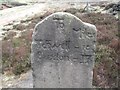
Sidney Oldall Addy in his 1888 book 'A glossary of words used in the neighbourhood of Sheffield' states, "A gamekeeper's house called Oxdale Lodge is next approached on the right-hand side of (Houndkirk) road. The house fronts the south-east, and looks straight down a clough or deep valley, watered by a runlet, by whose banks grows here and there a mountain ash. Adjacent to the spot where Oxdale Lodge stands, Fairbank's map records a stone called Harrys Stone. I asked the gamekeeper of Oxdale Lodge whether he knew of such a stone. He replied that he did not, and had never heard of it. I have, nevertheless, no doubt of the accuracy of Fairbank's survey, and can only suppose that the name has been lost and the stone removed. Harry is the Anglo-Saxon hearh or hearg (pronounced harry), meaning a temple or idol, as may be seen in Adamfield Harrie, Holmesfield."
You may be viewing yesterday's version of this page. To see the most up to date information please register for a free account.
")
")
Do not use the above information on other web sites or publications without permission of the contributor.
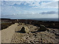
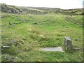
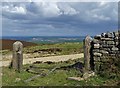
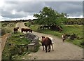
Nearby Images from Geograph Britain and Ireland:
©2014(licence)
©2010(licence)
©2005(licence)
©2020(licence)
©2020(licence)
The above images may not be of the site on this page, they are loaded from Geograph.
Please Submit an Image of this site or go out and take one for us!
Click here to see more info for this site
Nearby sites
Key: Red: member's photo, Blue: 3rd party photo, Yellow: other image, Green: no photo - please go there and take one, Grey: site destroyed
Download sites to:
KML (Google Earth)
GPX (GPS waypoints)
CSV (Garmin/Navman)
CSV (Excel)
To unlock full downloads you need to sign up as a Contributory Member. Otherwise downloads are limited to 50 sites.
Turn off the page maps and other distractions
Nearby sites listing. In the following links * = Image available
316m SSE 162° God's Spring* Holy Well or Sacred Spring (SK283821)
1.3km SE 138° Giant's Chair (Yorkshire)* Standing Stone (Menhir) (SK291814)
1.7km SSW 211° Fingerem Stone* Cairn (SK273809)
1.8km SSW 203° Ciceley Low II* Ring Cairn (SK2752080782)
1.8km SSW 203° Ciceley Low I* Ring Cairn (SK2752080782)
2.4km WSW 248° Carl Wark* Hillfort (SK260815)
2.5km S 169° Strawberry Lea* Ring Cairn (SK287799)
2.9km WSW 239° Hathersage Moor Ring Cairn (SK257809)
3.0km SW 233° Toads Mouth (Hathersage)* Natural Stone / Erratic / Other Natural Feature (SK258806)
3.0km ESE 115° Peace Well* Holy Well or Sacred Spring (SK3093881126)
3.1km WSW 250° Winyards Nick* Round Barrow(s) (SK253813)
3.4km SSW 208° Little John's Well (Hathersage)* Holy Well or Sacred Spring (SK266794)
3.5km S 170° Brown Edge* Stone Circle (SK288790)
3.9km SW 228° Lawrence Field* Stone Circle (SK253798)
4.0km WNW 288° Robin Hood's Cave* Cave or Rock Shelter (SK244836)
4.1km NNW 342° Ash Cabin Flat* Stone Circle (SK2693186251)
4.1km NNW 345° Ash Cabin Fort* Hillfort (SK271864)
4.2km NNW 344° Ash Cabin standing stone* Standing Stone (Menhir) (SK270864)
4.4km E 81° Ecclesall Woods* Rock Art (SK326831)
4.5km S 169° Owler Bar Cairn (SK291780)
4.9km SSW 196° The Hurkling Stone* Marker Stone (SK269777)
4.9km NNW 337° Reddicar Clough (Hallam Moor) Cairn (SK26248688)
4.9km WNW 282° Trinity Well (Hathersage)* Holy Well or Sacred Spring (SK234834)
4.9km WNW 285° North Lees Romano British Village* Ancient Village or Settlement (SK2343083673)
5.0km SSW 196° White Edge Cairn* Cairn (SK26847762)
View more nearby sites and additional images


 We would like to know more about this location. Please feel free to add a brief description and any relevant information in your own language.
 Wir möchten mehr über diese Stätte erfahren. Bitte zögern Sie nicht, eine kurze Beschreibung und relevante Informationen in Deutsch hinzuzufügen.
 Nous aimerions en savoir encore un peu sur les lieux. S'il vous plaît n'hesitez pas à ajouter une courte description et tous les renseignements pertinents dans votre propre langue.
 Quisieramos informarnos un poco más de las lugares. No dude en añadir una breve descripción y otros datos relevantes en su propio idioma.