

<< Our Photo Pages >> Holy Stone (North Tyneside) - Ancient Cross in England in Tyne and Wear
Submitted by Anne T on Sunday, 04 February 2018 Page Views: 4099
Early Medieval (Dark Age)Site Name: Holy Stone (North Tyneside)Country: England County: Tyne and Wear Type: Ancient Cross
Nearest Town: Tynemouth / Whiteley Bay Nearest Village: Holystone / Benton
Map Ref: NZ30137066
Latitude: 55.029561N Longitude: 1.530187W
Condition:
| 5 | Perfect |
| 4 | Almost Perfect |
| 3 | Reasonable but with some damage |
| 2 | Ruined but still recognisable as an ancient site |
| 1 | Pretty much destroyed, possibly visible as crop marks |
| 0 | No data. |
| -1 | Completely destroyed |
| 5 | Superb |
| 4 | Good |
| 3 | Ordinary |
| 2 | Not Good |
| 1 | Awful |
| 0 | No data. |
| 5 | Can be driven to, probably with disabled access |
| 4 | Short walk on a footpath |
| 3 | Requiring a bit more of a walk |
| 2 | A long walk |
| 1 | In the middle of nowhere, a nightmare to find |
| 0 | No data. |
| 5 | co-ordinates taken by GPS or official recorded co-ordinates |
| 4 | co-ordinates scaled from a detailed map |
| 3 | co-ordinates scaled from a bad map |
| 2 | co-ordinates of the nearest village |
| 1 | co-ordinates of the nearest town |
| 0 | no data |
Internal Links:
External Links:
I have visited· I would like to visit
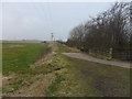
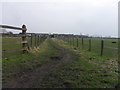
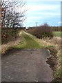
Anne T visited on 3rd Feb 2018 - their rating: Cond: -1 Amb: 2 Access: 4 Holy Stone Cross Base, North Tyneside: Having been to the industrial estate nearby, we decided to try and track down this stone. Donning wellies, as there had been torrential rain the night before, we followed the footpath from the Holystone Pub/Premier Inn (where there is a car park almost next to the A19, just north east of the pub) towards Holystone Farm, crossing the bridge above a busy railway line. At the recently built Holystone Cottage, another footpath runs north east across the fields towards the A19. The stone is supposed to be located at the junction of the footpath and the front wall of Holystone Cottage.
By chance we met a couple of dog walkers, and I asked them if they knew of this stone. The man said he was brought up locally and remembered playing in the fields at the back of the cottage, where there a three foot high stone they used to gather around. He said the stone had been destroyed some years ago, but the cross base might remain.
He walked us to the spot where he remembered the stone being, but nothing. He did say that there had been recent site investigation in the field, prior to building new houses.
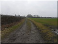
We did find what looked very much like a cross base in the corner of a neighbouring field at NZ 30210 70783. This looked very convincing from the side, but from the top, there was what might have been a long, thin, damaged slot, very unlike the carved slots we've seen in other cross bases.
 (PID:177815)")
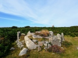
This site is marked on the OS map as a 'holy stone' and recorded as Pastscape Monument 26667 as the socket stone of a probably wayside cross. Local tradition says it is said to mark the site of a resting place for St. Cuthbert's body, on its way to Tynemouth. Pastscape tells us the socket stone measures 0.7m square with a socket hole measuring 0.2m by 0.15m and is made of local sandstone.
The grid reference puts this immediately next to the junction of the lane leading to Holystone Farm and the path to the east of the recently built Holystone Cottage. We found no sign of the stone, having searched in a radius of around 150 metres.
By chance, we met up with some dog walkers, and asked them if they had heard of this cross base. The gentleman replied that he had been brought up Forest Hall, locally, and could remember playing around a 3ft high stone in the middle of the field behind the cottage, at approx. NZ 30106 70756. He very kindly walked us to the location he remembered, but there was no sign of a cross base or the remains of a stone. He did add that the field had recently been surveyed/investigated for building works, and the cross base might have been removed.
After scouting around the area, at the northern end of the field, another footpath leads under the A19, and tucked away at the corner of this field at NZ 30210 70783 is a square shaped, cut stone. If this the cross base that has been moved, there is no distinct socket hole.
The last Pastscape reference to it was dated in 1968, so it would be interesting to find out what has happened to this stone.
You may be viewing yesterday's version of this page. To see the most up to date information please register for a free account.
 (PID:177816)")
Do not use the above information on other web sites or publications without permission of the contributor.
Nearby Images from Geograph Britain and Ireland:
©2015(licence)
©2015(licence)
©2015(licence)
©2012(licence)
©2009(licence)
The above images may not be of the site on this page, they are loaded from Geograph.
Please Submit an Image of this site or go out and take one for us!
Click here to see more info for this site
Nearby sites
Key: Red: member's photo, Blue: 3rd party photo, Yellow: other image, Green: no photo - please go there and take one, Grey: site destroyed
Download sites to:
KML (Google Earth)
GPX (GPS waypoints)
CSV (Garmin/Navman)
CSV (Excel)
To unlock full downloads you need to sign up as a Contributory Member. Otherwise downloads are limited to 50 sites.
Turn off the page maps and other distractions
Nearby sites listing. In the following links * = Image available
6.0km SW 226° St. Mary's Well (Jesmond)* Holy Well or Sacred Spring (NZ2584366508)
6.2km NE 40° Old Hartley Standing Stone* Standing Stone (Menhir) (NZ341755)
6.4km SE 146° Bede's World (Jarrow)* Ancient Cross (NZ33756542)
6.4km NE 39° Old Hartley Blue Stone* Marker Stone (NZ341757)
6.5km SW 220° Villa Reale cist, Jesmond* Cist (NZ26006562)
6.6km SE 146° Jarrow* Ancient Cross (NZ3387965216)
6.7km W 279° Hazlerigg cropmark (North) Ancient Village or Settlement (NZ23467172)
6.8km SSE 165° Bede's Well Holy Well or Sacred Spring (NZ31986415)
6.8km W 277° Hazlerigg cropmark (South) Ancient Village or Settlement (NZ23327140)
7.3km SW 227° Exhibition Park Circle* Modern Stone Circle etc (NZ2476265651)
7.6km SW 224° Great North Museum* Museum (NZ2485565168)
7.6km SW 224° Great North Museum (Rock Art)* Museum (NZ2485365162)
7.6km SW 224° Great North Museum (Anglo Saxon Stones)* Museum (NZ2485065160)
7.6km SW 224° The Ponteland Boulder* Rock Art (NZ24816518)
7.8km SW 225° The Museum of Antiquities* Museum (NZ246651)
8.3km SW 217° Cale Cross (Newcastle)* Ancient Cross (NZ25206392)
8.4km SW 222° St Andrew's Church (Gallowgate)* Early Christian Sculptured Stone (NZ2453564409)
8.4km SW 218° St Nicholas's Cathedral (Newcastle)* Ancient Cross (NZ2498664008)
8.5km SW 221° White Cross (Newcastle)* Ancient Cross (NZ24586426)
8.7km SW 217° White Friar Tower Cist Cist (NZ24876368)
9.0km NW 317° Northumberlandia* Modern Stone Circle etc (NZ2384777182)
9.8km WNW 292° Gardener's house crop mark, Dinnington Ancient Village or Settlement (NZ20977420)
10.2km SW 229° Elswick Road Cist Cist (NZ225639)
10.8km NNW 347° Bebside Road Henge Henge (NZ277812)
11.9km NNW 340° St Cuthbert's Church (Bedlington)* Sculptured Stone (NZ2605081813)
View more nearby sites and additional images


 We would like to know more about this location. Please feel free to add a brief description and any relevant information in your own language.
 Wir möchten mehr über diese Stätte erfahren. Bitte zögern Sie nicht, eine kurze Beschreibung und relevante Informationen in Deutsch hinzuzufügen.
 Nous aimerions en savoir encore un peu sur les lieux. S'il vous plaît n'hesitez pas à ajouter une courte description et tous les renseignements pertinents dans votre propre langue.
 Quisieramos informarnos un poco más de las lugares. No dude en añadir una breve descripción y otros datos relevantes en su propio idioma.