

<< Our Photo Pages >> St-Malo-de-la-Lande menhir - Standing Stone (Menhir) in France in Normandie:Manche (50)
Submitted by thecaptain on Saturday, 12 May 2007 Page Views: 5998
Neolithic and Bronze AgeSite Name: St-Malo-de-la-Lande menhir Alternative Name: Pierre des Rouettes ?Country: France
NOTE: This site is 7.572 km away from the location you searched for.
Département: Normandie:Manche (50) Type: Standing Stone (Menhir)
Nearest Town: Coutances Nearest Village: St-Malo-de-la-Lande
Latitude: 49.059600N Longitude: 1.5473W
Condition:
| 5 | Perfect |
| 4 | Almost Perfect |
| 3 | Reasonable but with some damage |
| 2 | Ruined but still recognisable as an ancient site |
| 1 | Pretty much destroyed, possibly visible as crop marks |
| 0 | No data. |
| -1 | Completely destroyed |
| 5 | Superb |
| 4 | Good |
| 3 | Ordinary |
| 2 | Not Good |
| 1 | Awful |
| 0 | No data. |
| 5 | Can be driven to, probably with disabled access |
| 4 | Short walk on a footpath |
| 3 | Requiring a bit more of a walk |
| 2 | A long walk |
| 1 | In the middle of nowhere, a nightmare to find |
| 0 | No data. |
| 5 | co-ordinates taken by GPS or official recorded co-ordinates |
| 4 | co-ordinates scaled from a detailed map |
| 3 | co-ordinates scaled from a bad map |
| 2 | co-ordinates of the nearest village |
| 1 | co-ordinates of the nearest town |
| 0 | no data |
Internal Links:
External Links:
I have visited· I would like to visit
TheCaptain has visited here
")
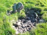
It looks a lot like a natural lump of rock, but there are no others like it around here, so it has obviously been placed here. Almost 2 metres in length, by 1.5 metres by 1 metre in dimensions, it is probably fallen and with its top cut off.
I am not sure if this is the "Pierre des Rouettes" which I have elsewhere found reference to as being at St-Malo-de-la-Lande, which we have here on the megalithic portal at nearby Blainville-sur-Mer.
IMPORTANT NOTE: Position of site taken from detailed map source.
You may be viewing yesterday's version of this page. To see the most up to date information please register for a free account.
")
")
Do not use the above information on other web sites or publications without permission of the contributor.
Nearby Images from Flickr


The above images may not be of the site on this page, but were taken nearby. They are loaded from Flickr so please click on them for image credits.
Click here to see more info for this site
Nearby sites
Click here to view sites on an interactive map of the areaKey: Red: member's photo, Blue: 3rd party photo, Yellow: other image, Green: no photo - please go there and take one, Grey: site destroyed
Download sites to:
KML (Google Earth)
GPX (GPS waypoints)
CSV (Garmin/Navman)
CSV (Excel)
To unlock full downloads you need to sign up as a Contributory Member. Otherwise downloads are limited to 50 sites.
Turn off the page maps and other distractions
Nearby sites listing. In the following links * = Image available
2.7km WNW 286° Menhir de Blainville-sur-Mer* Standing Stone (Menhir)
3.7km NW 326° Gouville-sur-Mer Menhir* Standing Stone (Menhir)
3.7km NE 43° Pierre de Mélier Standing Stone (Menhir)
4.4km NNW 332° Menhir de Gouville* Standing Stone (Menhir)
6.6km N 349° L'Oeuf de Gargantua* Standing Stone (Menhir)
8.0km N 353° Geffosses Ecole-des-Filles* Standing Stone (Menhir)
8.1km N 1° Droits a l'Homme* Modern Stone Circle etc
15.8km NNE 20° Millières menhir* Standing Stone (Menhir)
21.1km E 99° Menhir dit Pierre Bottin* Standing Stone (Menhir)
22.9km S 182° La Pierre Aigüe* Standing Stone (Menhir)
24.8km N 7° Bois du Mont* Passage Grave
25.2km N 9° Dolmen du Bois de la Plesse* Burial Chamber or Dolmen
25.4km N 9° Allée couverte du Bois de la Plesse (Sud)* Passage Grave
25.4km N 9° Allée couverte du Bois de la Plesse (Nord)* Passage Grave
27.9km ESE 115° Menhir de Maupertuis Standing Stone (Menhir)
28.4km SW 225° Cromlech de l'Oeillet* Stone Circle
28.8km NNW 343° Pierre à l'Homme Standing Stone (Menhir)
29.2km SW 224° Pierre du Sacrifice (Iles Chausey) Burial Chamber or Dolmen
29.2km SW 226° Dolmen dit Maison des Morts Burial Chamber or Dolmen
29.5km SW 227° Genétaie coffres 2 to 4 Burial Chamber or Dolmen
29.6km SW 227° Genétaie coffre 1 Burial Chamber or Dolmen
31.9km S 178° Menhir dit Pierre du Diable (Vaumoisson)* Standing Stone (Menhir)
32.5km NNE 20° Dolmen du Champ de la Pierre Burial Chamber or Dolmen
33.4km NNE 26° Pierre Lée (Appeville) Burial Chamber or Dolmen
35.2km N 9° Pierre Butée* Standing Stone (Menhir)
View more nearby sites and additional images


 We would like to know more about this location. Please feel free to add a brief description and any relevant information in your own language.
 Wir möchten mehr über diese Stätte erfahren. Bitte zögern Sie nicht, eine kurze Beschreibung und relevante Informationen in Deutsch hinzuzufügen.
 Nous aimerions en savoir encore un peu sur les lieux. S'il vous plaît n'hesitez pas à ajouter une courte description et tous les renseignements pertinents dans votre propre langue.
 Quisieramos informarnos un poco más de las lugares. No dude en añadir una breve descripción y otros datos relevantes en su propio idioma.