


<< Our Photo Pages >> Haydown Hill Field System - Misc. Earthwork in England in Wiltshire
Submitted by SolarMegalith on Wednesday, 06 June 2012 Page Views: 4768
Multi-periodSite Name: Haydown Hill Field SystemCountry: England
NOTE: This site is 2.785 km away from the location you searched for.
County: Wiltshire Type: Misc. Earthwork
Nearest Village: Vernham Dean
Map Ref: SU324563
Latitude: 51.304903N Longitude: 1.536606W
Condition:
| 5 | Perfect |
| 4 | Almost Perfect |
| 3 | Reasonable but with some damage |
| 2 | Ruined but still recognisable as an ancient site |
| 1 | Pretty much destroyed, possibly visible as crop marks |
| 0 | No data. |
| -1 | Completely destroyed |
| 5 | Superb |
| 4 | Good |
| 3 | Ordinary |
| 2 | Not Good |
| 1 | Awful |
| 0 | No data. |
| 5 | Can be driven to, probably with disabled access |
| 4 | Short walk on a footpath |
| 3 | Requiring a bit more of a walk |
| 2 | A long walk |
| 1 | In the middle of nowhere, a nightmare to find |
| 0 | No data. |
| 5 | co-ordinates taken by GPS or official recorded co-ordinates |
| 4 | co-ordinates scaled from a detailed map |
| 3 | co-ordinates scaled from a bad map |
| 2 | co-ordinates of the nearest village |
| 1 | co-ordinates of the nearest town |
| 0 | no data |
Internal Links:
External Links:
I have visited· I would like to visit
SolarMegalith visited on 1st Jun 2012 - their rating: Cond: 3 Amb: 4 Access: 3
")
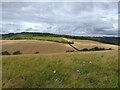
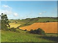
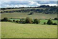
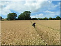
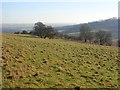
Remains of this Celtic field system, possibly associated with Fosbury Camp hillfort, are visible on SE slope of Haydown Hill. The preserved lynchets are up to 1 m high, the best preserved one are located just below the hillfort.
Read More at Pastscape.
You may be viewing yesterday's version of this page. To see the most up to date information please register for a free account.
")
Do not use the above information on other web sites or publications without permission of the contributor.
Nearby Images from Geograph Britain and Ireland:
©2023(licence)
©2005(licence)
©2020(licence)
©2011(licence)
©2008(licence)
The above images may not be of the site on this page, they are loaded from Geograph.
Please Submit an Image of this site or go out and take one for us!
Click here to see more info for this site
Nearby sites
Key: Red: member's photo, Blue: 3rd party photo, Yellow: other image, Green: no photo - please go there and take one, Grey: site destroyed
Download sites to:
KML (Google Earth)
GPX (GPS waypoints)
CSV (Garmin/Navman)
CSV (Excel)
To unlock full downloads you need to sign up as a Contributory Member. Otherwise downloads are limited to 50 sites.
Turn off the page maps and other distractions
Nearby sites listing. In the following links * = Image available
537m WNW 292° Fosbury Camp* Hillfort (SU319565)
2.2km S 175° Bevisbury* Hillfort (SU326541)
2.3km WSW 241° Kenward stone* Natural Stone / Erratic / Other Natural Feature (SU304552)
3.4km WNW 293° Tidcombe Long Barrow* Long Barrow (SU2924957610)
3.7km W 264° Grim's Ditch 1 (Wiltshire) Misc. Earthwork (SU287559)
3.9km W 267° Chute 1 Long Barrow Long Barrow (SU28455609)
4.7km WNW 292° Tidcombe and Fosbury Mound Round Barrow(s) (SU2804957991)
5.1km W 271° Grafton 8 Bowl Barrow* Round Barrow(s) (SU27285636)
5.2km WNW 287° Tow Barrow* Long Barrow (SU27425775)
5.3km W 270° Grafton 9-11 Disc Barrows* Barrow Cemetery (SU271563)
5.6km SE 136° Blagden Copse Bowl Barrow Round Barrow(s) (SU36305228)
6.3km NNE 24° Inkpen Hill Barrows* Barrow Cemetery (SU34966203)
6.8km WSW 243° Collingbourne Ducis 22 Bowl Barrow* Round Barrow(s) (SU26405317)
6.8km W 274° Collingbourne Kingston 21 Long Barrow* Long Barrow (SU25645671)
6.8km S 174° Nutbane* Long Barrow (SU33104952)
7.3km NE 35° Inkpen Long Barrow* Long Barrow (SU365623)
7.3km NE 43° Walbury Camp* Hillfort (SU374617)
7.4km ESE 123° Severals Copse Bowl Barrow* Round Barrow(s) (SU38615227)
7.9km SW 230° Ludgershall Castle Southern Enclosure* Misc. Earthwork (SU2639051130)
8.0km NW 316° Dodsdown Bowl Barrow Round Barrow(s) (SU2677862069)
9.1km S 175° Penton Park Bowl Barrow Round Barrow(s) (SU3326247217)
9.4km NNW 331° Great Bedwyn Puddingstone* Marker Stone (SU278645)
10.1km N 0° Standon Manor Puddingstone Natural Stone / Erratic / Other Natural Feature (SU324664)
10.2km NNW 342° Little Bedwyn Puddingstones Natural Stone / Erratic / Other Natural Feature (SU291660)
10.6km WSW 244° Cow Down Barrow Cemetery Barrow Cemetery (SU229516)
View more nearby sites and additional images


 We would like to know more about this location. Please feel free to add a brief description and any relevant information in your own language.
 Wir möchten mehr über diese Stätte erfahren. Bitte zögern Sie nicht, eine kurze Beschreibung und relevante Informationen in Deutsch hinzuzufügen.
 Nous aimerions en savoir encore un peu sur les lieux. S'il vous plaît n'hesitez pas à ajouter une courte description et tous les renseignements pertinents dans votre propre langue.
 Quisieramos informarnos un poco más de las lugares. No dude en añadir una breve descripción y otros datos relevantes en su propio idioma.