


<< Text Pages >> Culverley Farm Bowl Barrow - Round Barrow(s) in England in Hampshire
Submitted by SolarMegalith on Friday, 18 November 2011 Page Views: 2866
Neolithic and Bronze AgeSite Name: Culverley Farm Bowl BarrowCountry: England
NOTE: This site is 2.321 km away from the location you searched for.
County: Hampshire Type: Round Barrow(s)
Map Ref: SU37530461
Latitude: 50.839806N Longitude: 1.468369W
Condition:
| 5 | Perfect |
| 4 | Almost Perfect |
| 3 | Reasonable but with some damage |
| 2 | Ruined but still recognisable as an ancient site |
| 1 | Pretty much destroyed, possibly visible as crop marks |
| 0 | No data. |
| -1 | Completely destroyed |
| 5 | Superb |
| 4 | Good |
| 3 | Ordinary |
| 2 | Not Good |
| 1 | Awful |
| 0 | No data. |
| 5 | Can be driven to, probably with disabled access |
| 4 | Short walk on a footpath |
| 3 | Requiring a bit more of a walk |
| 2 | A long walk |
| 1 | In the middle of nowhere, a nightmare to find |
| 0 | No data. |
| 5 | co-ordinates taken by GPS or official recorded co-ordinates |
| 4 | co-ordinates scaled from a detailed map |
| 3 | co-ordinates scaled from a bad map |
| 2 | co-ordinates of the nearest village |
| 1 | co-ordinates of the nearest town |
| 0 | no data |
Internal Links:
External Links:
Round Barrow in Hampshire
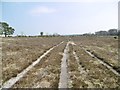
A Bronze Age bowl barrow of 16 m diameter and 1 m height, heavily mutilated.
Read More at Pastscape.
You may be viewing yesterday's version of this page. To see the most up to date information please register for a free account.
Do not use the above information on other web sites or publications without permission of the contributor.
Nearby Images from Geograph Britain and Ireland:
©2015(licence)
©2015(licence)
©2015(licence)
©2015(licence)
©2015(licence)
The above images may not be of the site on this page, they are loaded from Geograph.
Please Submit an Image of this site or go out and take one for us!
Click here to see more info for this site
Nearby sites
Key: Red: member's photo, Blue: 3rd party photo, Yellow: other image, Green: no photo - please go there and take one, Grey: site destroyed
Download sites to:
KML (Google Earth)
GPX (GPS waypoints)
CSV (Garmin/Navman)
CSV (Excel)
To unlock full downloads you need to sign up as a Contributory Member. Otherwise downloads are limited to 50 sites.
Turn off the page maps and other distractions
Nearby sites listing. In the following links * = Image available
1.8km NNE 33° Dibden Bottom* Barrow Cemetery (SU385061)
2.5km NW 320° Yew Tree Heath* Round Barrow(s) (SU3589506556)
2.7km NNE 33° The Dibden-Lynch Bottom Ring Henge
2.8km NE 46° Darcy Island* Round Barrow(s) (SU39520654)
3.0km NNE 23° Ipley Cross* Round Barrow(s) (SU38670735)
3.8km ESE 115° Beaulieu Heath (East)* Round Barrow(s) (SU4103)
3.9km NNW 342° Longdown (New Forest) tumuli* Round Barrow(s) (SU363083)
4.8km SW 235° Pudding Barrow* Round Barrow(s) (SU336018)
5.3km NW 313° Matley Heath* Round Barrow(s) (SU336082)
5.5km NW 315° Ashurst Lodge Earthworks* Misc. Earthwork (SU336085)
5.8km SW 218° Beaulieu Heath (West)* Round Barrow(s) (SU3400)
6.2km SSW 213° Laurences Barrow* Round Barrow(s) (SZ34139937)
7.3km SE 144° Exbury Promontory Fort / Cliff Castle (SZ419987)
8.3km WNW 296° New Forest Museum* Museum (SU30020813)
8.8km ESE 109° Poppy Pond* Round Barrow(s) (SU45920174)
9.1km WSW 240° Setley Plain disc barrows* Round Barrow(s) (SU29620002)
9.3km ESE 111° Talia's Torque* Round Barrow(s) (SU46240138)
9.4km W 265° Ober Heath* Round Barrow(s) (SU281037)
9.9km SW 218° Buckland Rings* Ancient Village or Settlement (SZ315968)
10.1km SW 233° Shirley Holms* Round Barrow(s) (SZ295985)
10.8km NNW 336° Tatchbury Mount Hillfort (SU330144)
10.8km WSW 244° Longslade View tumulus* Round Barrow(s) (SZ278998)
11.3km NNW 344° Testwood Lakes* Museum (SU344155)
11.9km NNW 332° Money Hills Barrow Cemetery (SU31771505)
12.1km W 264° Ferny Knap tumuli* Round Barrow(s) (SU255032)
View more nearby sites and additional images


 We would like to know more about this location. Please feel free to add a brief description and any relevant information in your own language.
 Wir möchten mehr über diese Stätte erfahren. Bitte zögern Sie nicht, eine kurze Beschreibung und relevante Informationen in Deutsch hinzuzufügen.
 Nous aimerions en savoir encore un peu sur les lieux. S'il vous plaît n'hesitez pas à ajouter une courte description et tous les renseignements pertinents dans votre propre langue.
 Quisieramos informarnos un poco más de las lugares. No dude en añadir una breve descripción y otros datos relevantes en su propio idioma.