


<< Other Photo Pages >> Barwick in Elmet Hillfort - Hillfort in England in Yorkshire (West)
Submitted by Andy B on Tuesday, 03 September 2013 Page Views: 12762
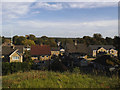
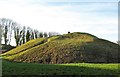
Iron Age and Later PrehistorySite Name: Barwick in Elmet HillfortCountry: England County: Yorkshire (West) Type: Hillfort
Nearest Town: Leeds Nearest Village: Barwick in Elmet
Map Ref: SE398375
Latitude: 53.832242N Longitude: 1.396752W
Condition:
| 5 | Perfect |
| 4 | Almost Perfect |
| 3 | Reasonable but with some damage |
| 2 | Ruined but still recognisable as an ancient site |
| 1 | Pretty much destroyed, possibly visible as crop marks |
| 0 | No data. |
| -1 | Completely destroyed |
| 5 | Superb |
| 4 | Good |
| 3 | Ordinary |
| 2 | Not Good |
| 1 | Awful |
| 0 | No data. |
| 5 | Can be driven to, probably with disabled access |
| 4 | Short walk on a footpath |
| 3 | Requiring a bit more of a walk |
| 2 | A long walk |
| 1 | In the middle of nowhere, a nightmare to find |
| 0 | No data. |
| 5 | co-ordinates taken by GPS or official recorded co-ordinates |
| 4 | co-ordinates scaled from a detailed map |
| 3 | co-ordinates scaled from a bad map |
| 2 | co-ordinates of the nearest village |
| 1 | co-ordinates of the nearest town |
| 0 | no data |
Internal Links:
External Links:
")
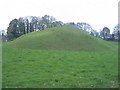
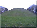
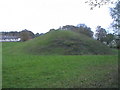
The Iron Age hillfort encloses the summits of two adjacent hills;Wendel Hill and Hall Tower Hill. Substantial remains of the hillfort's enclosing bank and ditch have survived on Wendel Hill (up to 4.5m high from base to summit) and on the south-west part of Hall Tower Hill; though these were modified in the 12th century.
The south circuit of the bank and ditch, on the south side of Hall Tower Hill, was also identified during construction work in the 1960s. The remains of a massive inturned entrance are visible on the north-west side of Wendel Hill, and much of the interior of the hillfort has survived. Various finds have been uncovered including coins dating to the second century BC and first century AD.
More at Pastscape
Note: Guided tours of this largely unvisited hill fort with Norman fortifications inside it. Fri 13th/Sat 14th September
You may be viewing yesterday's version of this page. To see the most up to date information please register for a free account.
")
")
")
Do not use the above information on other web sites or publications without permission of the contributor.
Nearby Images from Geograph Britain and Ireland:
©2019(licence)
©2011(licence)
©2011(licence)
©2011(licence)
©2018(licence)
The above images may not be of the site on this page, they are loaded from Geograph.
Please Submit an Image of this site or go out and take one for us!
Click here to see more info for this site
Nearby sites
Key: Red: member's photo, Blue: 3rd party photo, Yellow: other image, Green: no photo - please go there and take one, Grey: site destroyed
Download sites to:
KML (Google Earth)
GPX (GPS waypoints)
CSV (Garmin/Navman)
CSV (Excel)
To unlock full downloads you need to sign up as a Contributory Member. Otherwise downloads are limited to 50 sites.
Turn off the page maps and other distractions
Nearby sites listing. In the following links * = Image available
3.5km E 96° St Ricarius (Aberford) Ancient Cross (SE4331037170)
4.0km W 278° Grim's Dyke* Misc. Earthwork (SE358380)
6.5km NNW 331° All Hallows (Bardsey)* Ancient Cross (SE3656143122)
7.2km W 264° Gipton Wood Ancient Village or Settlement (SE32653664)
8.1km E 98° Saxton Church Ancient Cross (SE478364)
8.6km N 355° Collingham Crosses* Ancient Cross (SE3901546096)
9.7km NE 40° Newton Kyme Henge Henge (SE45934499)
9.7km WSW 247° Quarry Hill (Leeds) Ancient Village or Settlement (SE309336)
9.8km ESE 114° Sherburn Cross* Ancient Cross (SE488335)
9.9km NNE 33° St Helen's Well (Boston Spa)* Holy Well or Sacred Spring (SE45134583)
9.9km WSW 248° Lady Well (Leeds) Holy Well or Sacred Spring (SE30603373)
10.0km NW 304° Grey Stone (Harewood)* Rock Art (SE31474308)
10.0km WSW 246° St Peter's Minster Church (Kirkgate) Ancient Cross (SE30653330)
11.3km WSW 246° St Helen's Well (Holbeck) Holy Well or Sacred Spring (SE295329)
11.3km ENE 72° St John the Baptist (Kirkby Wharfe) Ancient Cross (SE50604107)
11.6km WSW 254° Gray Stone (Burley) Natural Stone / Erratic / Other Natural Feature (SE2865934229)
12.7km WNW 283° Adel Cupstone* Rock Art (SE274402)
13.8km N 357° Green Howe (North Deighton) Round Barrow(s) (SE38865124)
13.9km NNW 328° St Helen's Well (Kirkby Overblow)* Holy Well or Sacred Spring (SE32354920)
14.4km S 173° Featherstone Cursus Cursus (SE418232)
15.0km SSE 150° Angel Moon Field Cairn (SE47342449)
15.1km NNE 32° St Helen's Church (Bilton-in-Ainsty)* Ancient Cross (SE476504)
15.1km SSE 151° Round Hill Field (Ferrybridge) Cairn (SE47332444)
15.2km WNW 285° Long Stone (Adel) Standing Stone (Menhir) (SE25014119)
15.3km SSE 151° Ferrybridge Henge Henge (SE47462424)
View more nearby sites and additional images


 We would like to know more about this location. Please feel free to add a brief description and any relevant information in your own language.
 Wir möchten mehr über diese Stätte erfahren. Bitte zögern Sie nicht, eine kurze Beschreibung und relevante Informationen in Deutsch hinzuzufügen.
 Nous aimerions en savoir encore un peu sur les lieux. S'il vous plaît n'hesitez pas à ajouter une courte description et tous les renseignements pertinents dans votre propre langue.
 Quisieramos informarnos un poco más de las lugares. No dude en añadir una breve descripción y otros datos relevantes en su propio idioma.