


<< Our Photo Pages >> Loch of Brow - Broch or Nuraghe in Scotland in Shetland
Submitted by SolarMegalith on Sunday, 31 July 2011 Page Views: 3481
Iron Age and Later PrehistorySite Name: Loch of BrowCountry: Scotland
NOTE: This site is 4.174 km away from the location you searched for.
County: Shetland Type: Broch or Nuraghe
Nearest Village: Longfield
Map Ref: HU383156
Latitude: 59.923653N Longitude: 1.316727W
Condition:
| 5 | Perfect |
| 4 | Almost Perfect |
| 3 | Reasonable but with some damage |
| 2 | Ruined but still recognisable as an ancient site |
| 1 | Pretty much destroyed, possibly visible as crop marks |
| 0 | No data. |
| -1 | Completely destroyed |
| 5 | Superb |
| 4 | Good |
| 3 | Ordinary |
| 2 | Not Good |
| 1 | Awful |
| 0 | No data. |
| 5 | Can be driven to, probably with disabled access |
| 4 | Short walk on a footpath |
| 3 | Requiring a bit more of a walk |
| 2 | A long walk |
| 1 | In the middle of nowhere, a nightmare to find |
| 0 | No data. |
| 5 | co-ordinates taken by GPS or official recorded co-ordinates |
| 4 | co-ordinates scaled from a detailed map |
| 3 | co-ordinates scaled from a bad map |
| 2 | co-ordinates of the nearest village |
| 1 | co-ordinates of the nearest town |
| 0 | no data |
Internal Links:
External Links:
I have visited· I would like to visit
SolarMegalith visited on 15th Jun 2015 - their rating: Cond: 1 Amb: 4 Access: 1
")
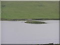
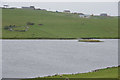
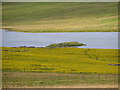
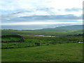
Barely visible remains of a broch located on a small islet on Loch of Brow. Only trace of a bank and a slight hollow marking interior of the broch have survived till nowadays.
MacKie E.W. 2002. The roundhouses, brochs and wheelhouses of Atlantic Scotland c. 700BC - AD500: architecture and material culture. Part 1 - The Orkney and Shetland Isles. British Archaeological Reports
You may be viewing yesterday's version of this page. To see the most up to date information please register for a free account.
")
Do not use the above information on other web sites or publications without permission of the contributor.
Nearby Images from Geograph Britain and Ireland:
©2010(licence)
©2010(licence)
©2010(licence)
©2010(licence)
©2008(licence)
The above images may not be of the site on this page, they are loaded from Geograph.
Please Submit an Image of this site or go out and take one for us!
Click here to see more info for this site
Nearby sites
Key: Red: member's photo, Blue: 3rd party photo, Yellow: other image, Green: no photo - please go there and take one, Grey: site destroyed
Download sites to:
KML (Google Earth)
GPX (GPS waypoints)
CSV (Garmin/Navman)
CSV (Excel)
To unlock full downloads you need to sign up as a Contributory Member. Otherwise downloads are limited to 50 sites.
Turn off the page maps and other distractions
Nearby sites listing. In the following links * = Image available
964m NNW 329° Lunabister* Broch or Nuraghe (HU37791642)
1.7km ESE 120° Southvoe Burnt Mound* Artificial Mound (HU39821475)
1.9km ESE 119° Southvoe Broch* Broch or Nuraghe (HU400147)
2.4km E 89° Broch of Dalsetter* Broch or Nuraghe (HU40751567)
2.7km ENE 68° Troswick* Standing Stone (Menhir) (HU40781662)
3.2km N 9° Ward Of Scousburgh* Cairn (HU38791880)
3.3km NE 41° Clumlie Broch* Broch or Nuraghe (HU404181)
3.8km NE 48° Knowe of Willol Burnt Mound* Artificial Mound (HU41091812)
4.7km SSE 157° Brough Head Broch* Broch or Nuraghe (HU4020511242)
5.0km S 174° Sumburgh Airport Broch* Broch or Nuraghe (HU389106)
5.2km NE 39° Levenwick Broch* Broch or Nuraghe (HU415197)
5.5km NNW 345° St Ninian's Isle* Ancient Village or Settlement (HU36852090)
6.1km NNE 28° Knowe Of Willil Burnt Mound* Artificial Mound (HU41122105)
6.2km SSE 167° Jarlshof* Ancient Village or Settlement (HU397096)
6.8km S 176° Tonga Fort, Scatness* Stone Fort or Dun (HU38890879)
7.3km S 177° Ness of Burgi* Stone Fort or Dun (HU387083)
9.9km NE 41° Burraland* Broch or Nuraghe (HU44682319)
10.9km NE 43° Mousa Broch* Broch or Nuraghe (HU457236)
11.1km NE 44° Mousa Burnt Mounds* Artificial Mound (HU45942370)
13.1km NNE 23° Broch of Mail* Broch or Nuraghe (HU43252779)
14.5km NNE 19° Everglades North Broch or Nuraghe (HU43002930)
14.9km NNE 23° Clodie Knowe* Broch or Nuraghe (HU441294)
15.9km N 355° Papil Pictish Stone Cross Slab* Class III Pictish Cross Slab (HU368315)
17.0km N 356° West Burra, Mid Field* Standing Stone (Menhir) (HU37003259)
17.0km N 356° West Burra, Mid Field Standing Stone (Menhir) (HU3700932591)
View more nearby sites and additional images


 We would like to know more about this location. Please feel free to add a brief description and any relevant information in your own language.
 Wir möchten mehr über diese Stätte erfahren. Bitte zögern Sie nicht, eine kurze Beschreibung und relevante Informationen in Deutsch hinzuzufügen.
 Nous aimerions en savoir encore un peu sur les lieux. S'il vous plaît n'hesitez pas à ajouter une courte description et tous les renseignements pertinents dans votre propre langue.
 Quisieramos informarnos un poco más de las lugares. No dude en añadir una breve descripción y otros datos relevantes en su propio idioma.