


<< Our Photo Pages >> Ryhope Caves - Cave or Rock Shelter in England in Tyne and Wear
Submitted by durhamnature on Thursday, 13 September 2012 Page Views: 6302
Natural PlacesSite Name: Ryhope Caves Alternative Name: Tunstall Hope cavesCountry: England County: Tyne and Wear Type: Cave or Rock Shelter
Nearest Town: Sunderland Nearest Village: Ryhope
Map Ref: NZ39985366
Latitude: 54.876112N Longitude: 1.378465W
Condition:
| 5 | Perfect |
| 4 | Almost Perfect |
| 3 | Reasonable but with some damage |
| 2 | Ruined but still recognisable as an ancient site |
| 1 | Pretty much destroyed, possibly visible as crop marks |
| 0 | No data. |
| -1 | Completely destroyed |
| 5 | Superb |
| 4 | Good |
| 3 | Ordinary |
| 2 | Not Good |
| 1 | Awful |
| 0 | No data. |
| 5 | Can be driven to, probably with disabled access |
| 4 | Short walk on a footpath |
| 3 | Requiring a bit more of a walk |
| 2 | A long walk |
| 1 | In the middle of nowhere, a nightmare to find |
| 0 | No data. |
| 5 | co-ordinates taken by GPS or official recorded co-ordinates |
| 4 | co-ordinates scaled from a detailed map |
| 3 | co-ordinates scaled from a bad map |
| 2 | co-ordinates of the nearest village |
| 1 | co-ordinates of the nearest town |
| 0 | no data |
Internal Links:
External Links:
")
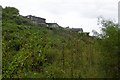
A series of small caves in magnesian limestone, in a south facing cliff overlooking the Tunstall Hope valley.
Tyne and Wear HER 160
Roger Miket NZ35SE number 11
Discovered in 1865 during limestone quarrying operations, the skeletons of 5 men, one woman, and one child were found in the caves, together with bones of goat, ox, pig, rabbit, sheep, dog, birds and fish. Shells and charcoal were also found.
Four of the skulls went to Sunderland Museum. Many of the bones and possibly some artifacts were removed by quarrymen and local people before the find became known to archaeologists. Consequently, this site is poorly recorded. A modern excavation in 1975 by A. Harding found very little.
The caves were cleared out and used as an air raid shelter during the second world war, and the valley bottom was later used to tip colliery spoil, filling it to a depth of 5 to 10 meters. Consequently, the caves, which had been part way up a 15 meter cliff, now have their entrances at surface level, and most of their length is below surface level. The caves were bricked up for safety reasons some years ago, but are now accessible again, to adventurous visitors. Each is a narrow squeeze down into a larger space. Beer cans and crisp packets show occasional use by teenagers.
The entrances of four caves are easily visible from footpaths or close to footpaths. Its not clear exactly which caves held the finds. Perhaps the remaining caves are the quarried remains of a larger, more complex cave. The caves are described in D. Brook's "Northern Caves" .
You may be viewing yesterday's version of this page. To see the most up to date information please register for a free account.
")
")
")
Do not use the above information on other web sites or publications without permission of the contributor.
Nearby Images from Geograph Britain and Ireland:
©2011(licence)
©2016(licence)
©2011(licence)
©2014(licence)
©2016(licence)
The above images may not be of the site on this page, they are loaded from Geograph.
Please Submit an Image of this site or go out and take one for us!
Click here to see more info for this site
Nearby sites
Key: Red: member's photo, Blue: 3rd party photo, Yellow: other image, Green: no photo - please go there and take one, Grey: site destroyed
Download sites to:
KML (Google Earth)
GPX (GPS waypoints)
CSV (Garmin/Navman)
CSV (Excel)
To unlock full downloads you need to sign up as a Contributory Member. Otherwise downloads are limited to 50 sites.
Turn off the page maps and other distractions
Nearby sites listing. In the following links * = Image available
1.2km NW 315° Tunstall Hills* Cist (NZ39145448)
3.1km N 357° Sunderland Museum and Winter Gardens* Museum (NZ398568)
4.1km N 3° St Peter's Church (Monkwearmouth)* Early Christian Sculptured Stone (NZ4016857783)
4.2km SW 215° Warden Law* Round Barrow(s) (NZ376502)
4.4km W 275° Offerton Cursus Cursus (NZ356540)
4.5km W 270° Offerton Cursus Cursus (NZ355536)
4.7km W 280° Hasting Hill* Round Barrow(s) (NZ353544)
6.5km SW 227° Copt Hill* Cairn (NZ353492)
6.9km WSW 237° St Michael and All Angels (Houghton-le-Spring)* Burial Chamber or Dolmen (NZ342498)
7.5km SW 218° Fairies Cradle* Round Barrow(s) (NZ35374771)
7.7km S 176° Batter Law Round Barrow(s) (NZ406460)
7.7km S 176° Batter Law Tumulus* Round Barrow(s) (NZ40604599)
7.7km SSE 155° Hawthorn Barrow* Round Barrow(s) (NZ433467)
7.9km SSW 194° Croup Hill Barrows, Murton Round Barrow(s) (NZ382460)
9.2km W 271° Fatfield Barrow* Round Barrow(s) (NZ30735374)
10.7km N 2° Whitburn Lizards Cave Cave or Rock Shelter (NZ403644)
11.9km W 269° North Lodge Cursus Cursus (NZ280533)
12.2km S 174° .Lows Hill Round Barrow(s) (NZ413415)
12.4km WNW 289° Sheddons Hill and Spring* Holy Well or Sacred Spring (NZ28125755)
12.6km W 260° The Anker's House* Ancient Cross (NZ27575131)
12.9km SW 230° Woodwell House Ancient Village or Settlement (NZ30074531)
13.1km NNW 333° Jarrow* Ancient Cross (NZ3387965216)
13.2km NW 323° Bede's Well Holy Well or Sacred Spring (NZ31986415)
13.3km NNW 333° Bede's World (Jarrow)* Ancient Cross (NZ33756542)
16.2km S 187° Old Wingate Round Barrow* Round Barrow(s) (NZ3815937568)
View more nearby sites and additional images


 We would like to know more about this location. Please feel free to add a brief description and any relevant information in your own language.
 Wir möchten mehr über diese Stätte erfahren. Bitte zögern Sie nicht, eine kurze Beschreibung und relevante Informationen in Deutsch hinzuzufügen.
 Nous aimerions en savoir encore un peu sur les lieux. S'il vous plaît n'hesitez pas à ajouter une courte description et tous les renseignements pertinents dans votre propre langue.
 Quisieramos informarnos un poco más de las lugares. No dude en añadir una breve descripción y otros datos relevantes en su propio idioma.