


<< Our Photo Pages >> St John's Well (Osmotherley) - Holy Well or Sacred Spring in England in Yorkshire (North)
Submitted by Sunny100 on Wednesday, 16 June 2010 Page Views: 7660
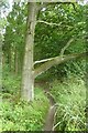
Springs and Holy WellsSite Name: St John's Well (Osmotherley) Alternative Name: Monks Well, Wishing WellCountry: England
NOTE: This site is 3.034 km away from the location you searched for.
County: Yorkshire (North) Type: Holy Well or Sacred Spring
Nearest Town: Northallerton Nearest Village: Osmotherley
Map Ref: SE447981
Latitude: 54.376449N Longitude: 1.31337W
Condition:
| 5 | Perfect |
| 4 | Almost Perfect |
| 3 | Reasonable but with some damage |
| 2 | Ruined but still recognisable as an ancient site |
| 1 | Pretty much destroyed, possibly visible as crop marks |
| 0 | No data. |
| -1 | Completely destroyed |
| 5 | Superb |
| 4 | Good |
| 3 | Ordinary |
| 2 | Not Good |
| 1 | Awful |
| 0 | No data. |
| 5 | Can be driven to, probably with disabled access |
| 4 | Short walk on a footpath |
| 3 | Requiring a bit more of a walk |
| 2 | A long walk |
| 1 | In the middle of nowhere, a nightmare to find |
| 0 | No data. |
| 5 | co-ordinates taken by GPS or official recorded co-ordinates |
| 4 | co-ordinates scaled from a detailed map |
| 3 | co-ordinates scaled from a bad map |
| 2 | co-ordinates of the nearest village |
| 1 | co-ordinates of the nearest town |
| 0 | no data |
Internal Links:
External Links:
I have visited· I would like to visit
church-grim would like to visit
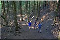
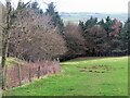
Anne T couldn't find on 5th Oct 2014 St John's Well (Osmotherlery): This being a glorious late afternoon, and having not only precise instructions on how to reach St John’s Well from the Mount Grace Priory staff but the GPS co-ordinates and a map I’d printed off with the exact location of the well, we set off to try and reach it. Not as easy as it first appeared! The first path, following what we both thought were the directions given to us, went too far up hill, then path just stopped at the top of the hill. Retracing our steps and turning on the GPS device, we followed the watercourse wending its way south away from the priory, between the edge of the forest and the adjoining meadow and found the track we should have followed. Whilst we could see the path leading up the hill towards the well, I let my husband take the lead, but it became just too difficult – waist high bracken, broken branches and large, boggy holes to fall into – it would have been too easy to twist and ankle or fall over. As it was getting late, we decided to come back in the winter, when the undergrowth has died back. We knew that this well was one of three which supplied the Priory, the first being in the north east corner, just outside the Great Cloister. A second is to the south of this, supplying the Lesser Cloister, and the third (not managed by English Heritage) is St. John’s Well. We did manage to get a photograph of Well House one. Despite there having been a lengthy dry spell, there was still a good flow of water from this spring, and the water was beautifully clear. There is a great similarity between the well house we saw and the image of St John's Well submitted by Sunny100.
coin have visited here
")
Local folklore records that young women used the well for wishing purposes. They would use bent pins stuck into leaves and throw them into the water whilst making a wish that was dearest to their hearts desire. If the pin floated the wish would come true, if it sunk then vice-versa. Miracles of healing have been attributed to the water. The nearby Lady Chapel was also the site of numerous miracles.
The well is housed within a small building with a pointed slate roof. The little door can be opened to gain access. Coins are sometimes tossed into the well, in the hope perhaps of some modern-day miracle of healing. The water is still said to be drinkable.
You may be viewing yesterday's version of this page. To see the most up to date information please register for a free account.
 (PID:125470)")
 (PID:125469)")
Do not use the above information on other web sites or publications without permission of the contributor.
Nearby Images from Geograph Britain and Ireland:
©2008(licence)
©2021(licence)
©2022(licence)
©2011(licence)
©2022(licence)
The above images may not be of the site on this page, they are loaded from Geograph.
Please Submit an Image of this site or go out and take one for us!
Click here to see more info for this site
Nearby sites
Key: Red: member's photo, Blue: 3rd party photo, Yellow: other image, Green: no photo - please go there and take one, Grey: site destroyed
Download sites to:
KML (Google Earth)
GPX (GPS waypoints)
CSV (Garmin/Navman)
CSV (Excel)
To unlock full downloads you need to sign up as a Contributory Member. Otherwise downloads are limited to 50 sites.
Turn off the page maps and other distractions
Nearby sites listing. In the following links * = Image available
282m NE 45° St John's Well (Northallerton) Holy Well or Sacred Spring (SE449983)
1.3km SE 137° St Peter (Osmotherly)* Ancient Cross (SE45579718)
2.2km NE 55° Scarth Wood Moor* Ancient Village or Settlement (SE4650499372)
2.2km NNE 15° All Saints (Ingleby Arncliffe)* Ancient Cross (NZ45270027)
2.7km SE 142° Thimbleby Moor 1* Rock Art (SE4639695988)
2.8km SE 140° Thimbleby Moor 3* Rock Art (SE4656395961)
2.8km SE 141° Thimbleby Moor 2* Rock Art (SE4652595928)
3.0km ENE 61° Near Moor 10a Rock Art (SE4735899599)
3.1km ENE 61° Near Moor 10b Rock Art (SE4738499612)
3.1km ENE 63° Near Moor 10f* Rock Art (SE4743599539)
3.1km ENE 61° Near Moor 10c Rock Art (SE4740399644)
3.1km ENE 62° Near Moor 10e Rock Art (SE4747099591)
3.1km NE 56° Near Moor 9a Rock Art (SE4730199887)
3.2km ENE 59° Near Moor 9c Rock Art (SE4741099782)
3.2km ENE 58° Near Moor 9b Rock Art (SE47409980)
3.2km ENE 61° Near Moor 10d* Rock Art (SE4749899665)
3.2km SE 135° Thimbleby Moor 4* Rock Art (SE4700895837)
3.2km NE 56° Near Moor 8a Rock Art (SE4737699928)
3.3km ENE 57° Near Moor 5b Rock Art (SE4747899932)
3.4km ENE 62° Near Moor 9d Rock Art (SE4765699733)
3.4km ENE 61° Near Moor 7a Rock Art (SE4765099761)
3.4km ENE 57° Near Moor 5a* Rock Art (SE4755499989)
3.4km ENE 59° Near Moor 6a* Rock Art (SE4762899909)
3.4km ENE 60° Near Moor 6b Rock Art (SE4766199877)
3.5km ENE 60° Near Moor 6c Rock Art (SE4769999864)
View more nearby sites and additional images


 We would like to know more about this location. Please feel free to add a brief description and any relevant information in your own language.
 Wir möchten mehr über diese Stätte erfahren. Bitte zögern Sie nicht, eine kurze Beschreibung und relevante Informationen in Deutsch hinzuzufügen.
 Nous aimerions en savoir encore un peu sur les lieux. S'il vous plaît n'hesitez pas à ajouter une courte description et tous les renseignements pertinents dans votre propre langue.
 Quisieramos informarnos un poco más de las lugares. No dude en añadir una breve descripción y otros datos relevantes en su propio idioma.