


<< Image Pages >> Tumulus de Vierville - Chambered Tomb in France in Normandie:Manche (50)
Submitted by TheCaptain on Sunday, 19 December 2004 Page Views: 6936
Neolithic and Bronze AgeSite Name: Tumulus de Vierville Alternative Name: Dolmen de Vierville, Tumulus de la ButteCountry: France
NOTE: This site is 12.639 km away from the location you searched for.
Département: Normandie:Manche (50) Type: Chambered Tomb
Nearest Town: Carentan Nearest Village: Vierville
Latitude: 49.359100N Longitude: 1.2484W
Condition:
| 5 | Perfect |
| 4 | Almost Perfect |
| 3 | Reasonable but with some damage |
| 2 | Ruined but still recognisable as an ancient site |
| 1 | Pretty much destroyed, possibly visible as crop marks |
| 0 | No data. |
| -1 | Completely destroyed |
| 5 | Superb |
| 4 | Good |
| 3 | Ordinary |
| 2 | Not Good |
| 1 | Awful |
| 0 | No data. |
| 5 | Can be driven to, probably with disabled access |
| 4 | Short walk on a footpath |
| 3 | Requiring a bit more of a walk |
| 2 | A long walk |
| 1 | In the middle of nowhere, a nightmare to find |
| 0 | No data. |
| 5 | co-ordinates taken by GPS or official recorded co-ordinates |
| 4 | co-ordinates scaled from a detailed map |
| 3 | co-ordinates scaled from a bad map |
| 2 | co-ordinates of the nearest village |
| 1 | co-ordinates of the nearest town |
| 0 | no data |
Internal Links:
External Links:
I have visited· I would like to visit
TheCaptain visited on 19th Nov 2004 - their rating: Access: 1 Try as I might, early in the morning on the way to my sisters from the ferry, by driving up and down every lane and farm track around the village, I couldn’t find any sign of this, despite it being highlighted as a tourist place on the IGN maps. I asked a chap passing on his way to work on a bike if he knew anything of it with no luck, and also an old couple herding cows from one field to another, who said they had lived there all their lives but had also never heard of it. They seemed very intrigued as to what an Englishman was doing in their village asking for a monument and pointing at something on a map. It must have made their day, but it didn’t help me in any way.
After taking a last guess and driving half a mile up a muddy track to the top of a nearby hill, and walking round all the woodland on the top, all I could find was a couple of interested donkeys. An hour had now gone by, and it was time to get on. Not much of a tourist attraction ! Further investigation using more detailed local maps showed the tumulus positioned right opposite the road junction by the church. If accurate, this meant that the tumulus was either in the garden of a large house, or in a nearby farmyard.
Passing near by the site on the way back to the ferry, I stopped off for another look round, this time knowing where to look. There was absolutely no sign of anything to be seen in any farmyards unless it has been covered with either a barn or a dungheap. This left the only place for it to be as in the walled in garden of the large house pictured, which had absolutely no places to look through. I could find nobody around to ask, and didn’t want to just go and call at a perhaps random private house, so had to give up again. It wouldn’t surprise me if it is positioned somewhere under the trees to be seen in the walled garden.
Once home, lots of painstaking research on the internet has revealed nothing more than that it is on private land. Its gotta be in that walled garden. Or is it ?
")
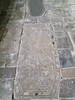
The tumulus consisted of four juxtaposed monuments, a central circular cairn containing a chamber opening to the outside via an entrance corridor. Two further structures of unknown function, symmetrically positioned at the north and the south named by the archaeologist as antennas, and an extension of the cairn in southern antenna containing a second chamber.
However, it is difficult to find and said to be on private land, which I believe is out of all sight within a large walled garden.
You may be viewing yesterday's version of this page. To see the most up to date information please register for a free account.
")
Do not use the above information on other web sites or publications without permission of the contributor.
Nearby Images from Flickr
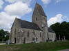
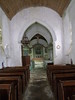
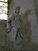
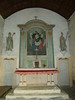
The above images may not be of the site on this page, but were taken nearby. They are loaded from Flickr so please click on them for image credits.
Click here to see more info for this site
Nearby sites
Click here to view sites on an interactive map of the areaKey: Red: member's photo, Blue: 3rd party photo, Yellow: other image, Green: no photo - please go there and take one, Grey: site destroyed
Download sites to:
KML (Google Earth)
GPX (GPS waypoints)
CSV (Garmin/Navman)
CSV (Excel)
To unlock full downloads you need to sign up as a Contributory Member. Otherwise downloads are limited to 50 sites.
Turn off the page maps and other distractions
Nearby sites listing. In the following links * = Image available
7.4km NW 318° Ste-Mère-Eglise Borne Gallo/Roman* Marker Stone
7.8km WSW 245° Pierre Lée (Appeville) Burial Chamber or Dolmen
11.1km WSW 256° Dolmen du Champ de la Pierre Burial Chamber or Dolmen
16.0km W 275° Pierre Butée* Standing Stone (Menhir)
17.7km NNW 347° Menhir de Quinéville Standing Stone (Menhir)
19.6km WSW 245° Dolmen du Bois de la Plesse* Burial Chamber or Dolmen
19.7km WSW 246° Allée couverte du Bois de la Plesse (Nord)* Passage Grave
19.7km WSW 246° Allée couverte du Bois de la Plesse (Sud)* Passage Grave
20.5km WSW 245° Bois du Mont* Passage Grave
24.7km SW 222° Millières menhir* Standing Stone (Menhir)
25.4km NNW 333° Montaigu-la-Brisette dolmen Burial Chamber or Dolmen
25.7km NNW 333° Les Grises Pierres* Standing Stones
26.2km NW 304° Pierre Dressée (Nègreville) Standing Stone (Menhir)
28.4km NW 308° Menhir dit Pierre Dressée Standing Stone (Menhir)
28.4km WNW 301° Table des Fées (Rocheville)* Passage Grave
28.8km WNW 302° Allée Couverte de Câtillon Passage Grave
28.8km NW 305° Galerie des Forges Passage Grave
29.1km WNW 301° Petite Roche allée couverte* Passage Grave
30.5km W 259° Pierre à l'Homme Standing Stone (Menhir)
33.2km SW 221° Droits a l'Homme* Modern Stone Circle etc
34.0km SW 222° Geffosses Ecole-des-Filles* Standing Stone (Menhir)
34.2km NW 324° Menhirs du Mesnil-Auval Standing Stones
35.1km W 276° Allée Couverte d'Haye d'Ectot* Passage Grave
35.3km SW 221° L'Oeuf de Gargantua* Standing Stone (Menhir)
36.1km SSW 212° Pierre de Mélier Standing Stone (Menhir)
View more nearby sites and additional images


 We would like to know more about this location. Please feel free to add a brief description and any relevant information in your own language.
 Wir möchten mehr über diese Stätte erfahren. Bitte zögern Sie nicht, eine kurze Beschreibung und relevante Informationen in Deutsch hinzuzufügen.
 Nous aimerions en savoir encore un peu sur les lieux. S'il vous plaît n'hesitez pas à ajouter une courte description et tous les renseignements pertinents dans votre propre langue.
 Quisieramos informarnos un poco más de las lugares. No dude en añadir una breve descripción y otros datos relevantes en su propio idioma.