 with our Megalithic Portal iPhone app")


<< Our Photo Pages >> The Island (Rugby School) - Round Barrow(s) in England in Warwickshire
Submitted by Iain_P on Thursday, 29 June 2017 Page Views: 2634
Neolithic and Bronze AgeSite Name: The Island (Rugby School)Country: England
NOTE: This site is 3.281 km away from the location you searched for.
County: Warwickshire Type: Round Barrow(s)
Nearest Town: Rugby
Map Ref: SP50367477
Latitude: 52.368672N Longitude: 1.261779W
Condition:
| 5 | Perfect |
| 4 | Almost Perfect |
| 3 | Reasonable but with some damage |
| 2 | Ruined but still recognisable as an ancient site |
| 1 | Pretty much destroyed, possibly visible as crop marks |
| 0 | No data. |
| -1 | Completely destroyed |
| 5 | Superb |
| 4 | Good |
| 3 | Ordinary |
| 2 | Not Good |
| 1 | Awful |
| 0 | No data. |
| 5 | Can be driven to, probably with disabled access |
| 4 | Short walk on a footpath |
| 3 | Requiring a bit more of a walk |
| 2 | A long walk |
| 1 | In the middle of nowhere, a nightmare to find |
| 0 | No data. |
| 5 | co-ordinates taken by GPS or official recorded co-ordinates |
| 4 | co-ordinates scaled from a detailed map |
| 3 | co-ordinates scaled from a bad map |
| 2 | co-ordinates of the nearest village |
| 1 | co-ordinates of the nearest town |
| 0 | no data |
Internal Links:
External Links:
I have visited· I would like to visit
pawel elad13 would like to visit
 (PID:167377)")
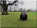
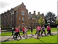
"The Island" is an impressive mound easily seen from the road.
Pastscape describes it as; "A possible motte, originally surrounded by a moat that was infilled in 1847. It has also been suggested that this was a barrow or moated site. Scheduled as an Ancient Monument." (List entry Number: 1002986)
The website gatehouse-gazetteer.info says: "the original nature of 'The Island' is uncertain. It could have been a BA barrow, a small motte, or even a mound constructed specifically for meditation by the monks of the Grange."
My mother is a local historian and has several old documents relating to 'the island' which support the claim that it is an ancient tumulus (images below). And on 19th Century maps it is marked as a tumulus.
For more information also see Pastscape Monument ID. 340198 which adds: The monks of Pipewell Abbey who had a grange here (SP 57 SW 4) "surrounded the ancient tumulus in the close with a moat, throwing the earth inwards and enlarging the space. This moat was filled from the land springs on the upper strata of the gravel .... O.W. Wait (1886) describes 'the island' as having a small ditch, but says that in 1797 this ditch was "a moat from 4' to 6' wide, and full of water. A wooden drawbridge with a spiked gate in the centre, crossed this at the place where the cricket pavillion now stands."
You may be viewing yesterday's version of this page. To see the most up to date information please register for a free account.
 (PID:167380)")
 (PID:167379)")
 (PID:167378)")
 (PID:167375)")
Do not use the above information on other web sites or publications without permission of the contributor.
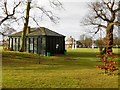
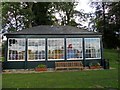
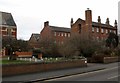
Nearby Images from Geograph Britain and Ireland:
©2011(licence)
©2012(licence)
©2016(licence)
©2012(licence)
©2012(licence)
The above images may not be of the site on this page, they are loaded from Geograph.
Please Submit an Image of this site or go out and take one for us!
Click here to see more info for this site
Nearby sites
Key: Red: member's photo, Blue: 3rd party photo, Yellow: other image, Green: no photo - please go there and take one, Grey: site destroyed
Download sites to:
KML (Google Earth)
GPX (GPS waypoints)
CSV (Garmin/Navman)
CSV (Excel)
To unlock full downloads you need to sign up as a Contributory Member. Otherwise downloads are limited to 50 sites.
Turn off the page maps and other distractions
Nearby sites listing. In the following links * = Image available
4.6km NNE 14° Churchover Bowl Barrow* Round Barrow(s) (SP51457929)
8.1km NW 307° Brinklow Tumulus* Artificial Mound (SP43877957)
9.2km SSE 159° Holy Well, Braunston* Holy Well or Sacred Spring (SP537662)
9.9km W 264° Knightlow barrow* Round Barrow(s) (SP405737)
9.9km W 268° Ryton on Dunsmore Cursus Cursus (SP404744)
12.3km NE 36° Tower Farm Long Barrow Long Barrow (SP575848)
12.4km NE 36° Misterton and Walcote Cursus Cursus (SP576848)
13.8km WSW 247° Wappenbury* Hillfort (SP377693)
13.8km N 356° Claybrooke Magna Standing Stone (Menhir) (SP493885)
14.1km ESE 104° Oster Hill (West Haddon) Cairn (SP64157145)
14.8km SE 146° Borough Hill (Daventry)* Hillfort (SP588626)
15.0km NNW 346° Wigston Parva Henge (SP467893)
15.6km ENE 61° Husbands Bosworth Causewayed Enclosure* Causewayed Enclosure (SP64018235)
15.8km SSW 214° Holy Well (Southam)* Holy Well or Sacred Spring (SP417615)
16.5km SSE 168° Arbury hill Hillfort (SP540587)
18.6km WNW 286° St. Catherine's Well (Coventry) Holy Well or Sacred Spring (SP323796)
18.9km ESE 121° Great Brington Medieval Cross Ancient Cross (SP6667765176)
20.0km NE 50° Mowsley Stone* Standing Stone (Menhir) (SP657877)
20.2km N 356° Stoney Stanton Stone Standing Stone (Menhir) (SP486949)
21.6km S 177° Byfield Cross Plinth Ancient Cross (SP516532)
22.2km SE 145° The Larches Ancient Village or Settlement (SP633567)
22.4km WNW 298° Burrow Hill Camp (Warwickshire)* Hillfort (SP304850)
22.6km N 6° Huncote Stone* Standing Stone (Menhir) (SP5246497256)
22.7km NNW 345° Barwell Stone* Standing Stone (Menhir) (SP4429096665)
23.1km N 355° Earl Shilton Bypass Round Barrow(s) (SP483978)
View more nearby sites and additional images

")
 We would like to know more about this location. Please feel free to add a brief description and any relevant information in your own language.
 Wir möchten mehr über diese Stätte erfahren. Bitte zögern Sie nicht, eine kurze Beschreibung und relevante Informationen in Deutsch hinzuzufügen.
 Nous aimerions en savoir encore un peu sur les lieux. S'il vous plaît n'hesitez pas à ajouter une courte description et tous les renseignements pertinents dans votre propre langue.
 Quisieramos informarnos un poco más de las lugares. No dude en añadir una breve descripción y otros datos relevantes en su propio idioma.