Featured: Lost Secrets - an adventure during Neolithic times

Lost Secrets - an adventure during Neolithic times

Serpent’s Gold by Sam Osman

Serpent’s Gold by Sam Osman

Who's Online

There are currently, 200 guests and 1 members online.

You are a guest. To join in, please register for free by clicking here

Sponsors

<< Our Photo Pages >> Eston Moor Pond Barrow - Round Barrow(s) in England in Yorkshire (North)

Submitted by SolarMegalith on Wednesday, 26 July 2017  Page Views: 1805

Neolithic and Bronze AgeSite Name: Eston Moor Pond Barrow
Country: England
NOTE: This site is 4.285 km away from the location you searched for.

County: Yorkshire (North) Type: Round Barrow(s)
Nearest Town: Middlesbrough
Map Ref: NZ56181732
Latitude: 54.548024N  Longitude: 1.133019W
Condition:
5Perfect
4Almost Perfect
3Reasonable but with some damage
2Ruined but still recognisable as an ancient site
1Pretty much destroyed, possibly visible as crop marks
0No data.
-1Completely destroyed
4 Ambience:
5Superb
4Good
3Ordinary
2Not Good
1Awful
0No data.
4 Access:
5Can be driven to, probably with disabled access
4Short walk on a footpath
3Requiring a bit more of a walk
2A long walk
1In the middle of nowhere, a nightmare to find
0No data.
3 Accuracy:
5co-ordinates taken by GPS or official recorded co-ordinates
4co-ordinates scaled from a detailed map
3co-ordinates scaled from a bad map
2co-ordinates of the nearest village
1co-ordinates of the nearest town
0no data
5

Internal Links:
External Links:

I have visited· I would like to visit

SolarMegalith visited on 24th Jul 2017 - their rating: Cond: 4 Amb: 4 Access: 3

Eston Moor Pond Barrow
Eston Moor Pond Barrow submitted by SolarMegalith : A well-preserved Bronze Age pond barrow with clearly distinguishable bank and central depression (photo taken on July 2017). (Vote or comment on this photo)
Round Barrow in Yorkshire (North)

A well preserved Bronze Age pond barrow is located near the footpath leading through Eston Hills towards the Eston Nab hillfort. or a ring cairn of 16m diameter with a centre sunk 0.8m below the top of the bank. The bank is up to 3m thick.

Pastscape entry.

You may be viewing yesterday's version of this page. To see the most up to date information please register for a free account.
Eston Moor Pond Barrow
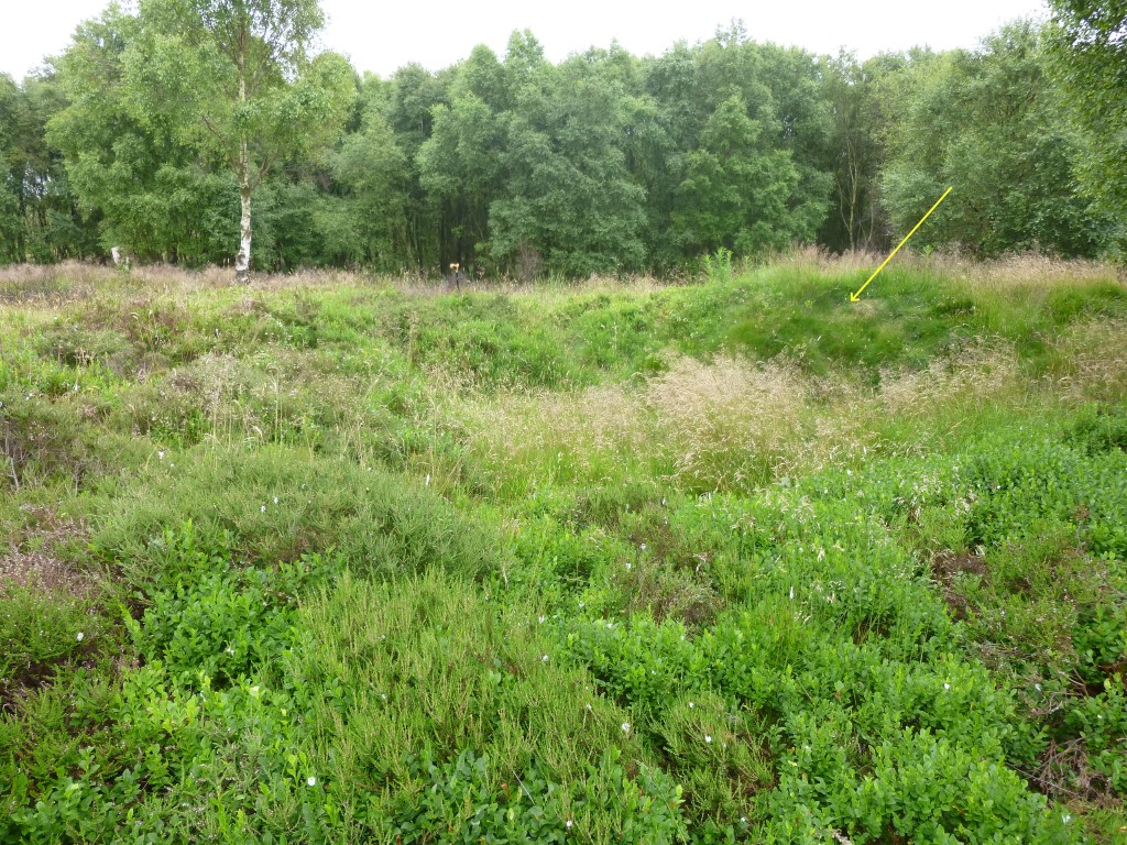
Eston Moor Pond Barrow submitted by johndhunter : Ring Cairn or possible pond barrow at NZ 56194 17325 – Viewed looking southerly July 2013. The arrow indicates the south west of the ring cairn where in the late 1970s spoil was dumped when they recut the track which runs close by, this has a tendency to obscure its shape. See the comments section at the bottom of this site page for further information on this ring cairn. (Vote or comment on this photo)

Eston Moor Pond Barrow
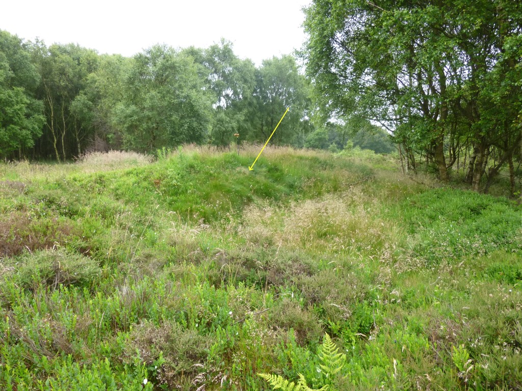
Eston Moor Pond Barrow submitted by johndhunter : Ring Cairn or possible pond barrow at NZ 56194 17325 – Viewed looking westerly July 2013. The raised bank indicated by the arrow at the south western part of the ring cairn is the result of over dumping of spoil when they recut the track which runs close by in the late 1970s. (Vote or comment on this photo)

Eston Moor Pond Barrow
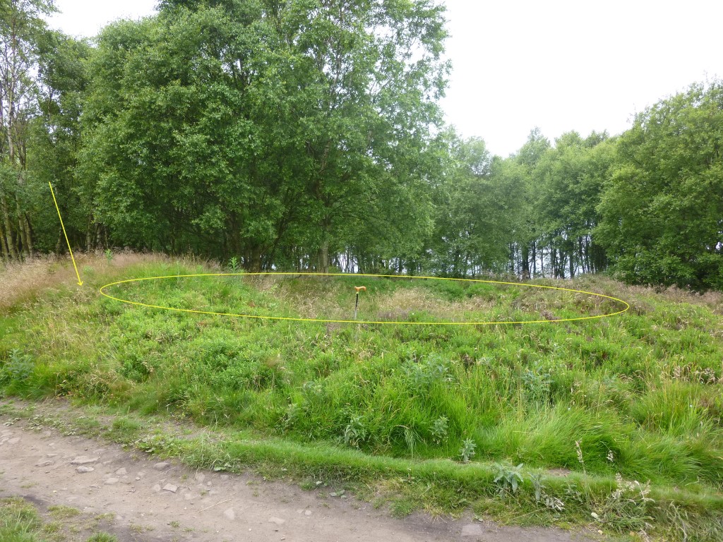
Eston Moor Pond Barrow submitted by johndhunter : Ring Cairn or possible pond barrow at NZ 56194 17325 – Viewed looking northerly July 2013.The raised bank indicated by the arrow at the south western part of the ring cairn is the result of over dumping of spoil when they recut the track which runs close by in the late 1970s. (Vote or comment on this photo)

Eston Moor Pond Barrow
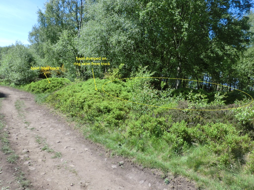
Eston Moor Pond Barrow submitted by johndhunter : Ring Cairn or possible pond barrow at NZ 56194 17325 – Viewed looking westerly May 2020. The ring cairn is very much over grown these days. Spoil was over dumped on the south western bank of the ring cairn as well as close by when they recut the track close by in the late 1970s. See the comments section at the bottom of this site page for further information on this ring cairn. (Vote or comment on this photo)

Eston Moor Pond Barrow
Eston Moor Pond Barrow submitted by SolarMegalith : Depression in the centre of the pond barrow and its bank (photo taken on July 2017).

Eston Moor Pond Barrow
Eston Moor Pond Barrow submitted by SolarMegalith : A Bronze Age pond barrow seen from the east (photo taken on July 2017).

Eston Moor Pond Barrow
Eston Moor Pond Barrow submitted by SolarMegalith : A general view of the Bronze Age pond barrow (photo taken on July 2017).

Do not use the above information on other web sites or publications without permission of the contributor.
Click here to see more info for this site

Nearby sites

Click here to view sites on an interactive OS map

Key: Red: member's photo, Blue: 3rd party photo, Yellow: other image, Green: no photo - please go there and take one, Grey: site destroyed

Download sites to:
KML (Google Earth)
GPX (GPS waypoints)
CSV (Garmin/Navman)
CSV (Excel)

To unlock full downloads you need to sign up as a Contributory Member. Otherwise downloads are limited to 50 sites.


Turn off the page maps and other distractions

Nearby sites listing. In the following links * = Image available
 212m E 84° Eston Moor 3b* Rock Art (NZ5639117343)
 301m ENE 69° Eston Moor Bowl Barrow* Round Barrow(s) (NZ5646117430)
 733m E 87° Moordale Bog 1* Rock Art (NZ5691417364)
 751m NE 38° Eston Moor B2* Round Barrow(s) (NZ5663317920)
 771m NE 39° Eston Moor B3* Cairn (NZ5665817926)
 858m SSW 205° Mount Pleasant (Eston)* Cairn (NZ55821654)
 1.0km NE 46° Eston Nab Bowl Barrows* Round Barrow(s) (NZ56901802)
 1.1km NE 34° Eston Nab Camp* Hillfort (NZ5679518248)
 4.3km S 170° Newton Under Roseberry Standing Stone* Standing Stone (Menhir) (NZ570131)
 4.9km SE 143° Hanging Stone (Hutton Lowcross Woods)* Rock Outcrop (NZ5914713460)
 4.9km ESE 120° Ruther Cross* Ancient Cross (NZ6044514960)
 5.0km SSE 161° Roseberry Topping* Natural Stone / Erratic / Other Natural Feature (NZ5791012603)
 5.2km SSE 148° Pinchinthorpe Moor tumuli* Cairn (NZ5900612945)
 5.6km SE 145° Newton Moor RC6 & RC7* Round Cairn (NZ5948612730)
 5.7km SE 145° Newton Moor RC5* Round Cairn (NZ5951412666)
 5.9km SE 145° Newton Moor RC4* Round Cairn (NZ5962612519)
 5.9km SE 145° Newton Moor RC3* Round Cairn (NZ5962812494)
 6.0km SE 145° Newton Moor RC2* Round Cairn (NZ5971312441)
 6.1km SE 144° Newton Moor RC1* Round Cairn (NZ5979412448)
 6.3km NNE 24° Foxrush Farm Ancient Village or Settlement (NZ5865123120)
 6.6km SE 145° Great Ayton Moor Cairns 2* Cairn (NZ6003611926)
 6.6km SSE 152° Great Ayton Moor Chambered Cairn* Cairn (NZ5939811514)
 6.8km SSE 154° Great Ayton Moor HC3* Ancient Village or Settlement (NZ5927311231)
 6.9km SE 133° Codhill Heights* Round Barrow(s) (NZ6136812677)
 7.0km SSE 150° Great Ayton Moor HC2* Ancient Village or Settlement (NZ5973611291)
View more nearby sites and additional images

<< Eston Moor Bowl Barrow

Stone Triangle (Lagganmullan) >>

Please add your thoughts on this site

Prehistoric Rock Art in the Northern Dales

Prehistoric Rock Art in the Northern Dales

Sponsors

Auto-Translation (Google)

Translate from English into:

"Eston Moor Pond Barrow" | Login/Create an Account | 2 News and Comments
  
Go back to top of page    Comments are owned by the poster. We aren't responsible for their content.
Re: Eston Moor Pond Barrow by johndhunter on Friday, 15 May 2020
(User Info | Send a Message)
Admin: Both Historic England and Pastscape describe this site as a Ring Cairn (see my previous comment for more information) I believe the accuracy of the site page would be enhanced if the Type was changed from Round Barrow to Ring Cairn and perhaps an update be made in the description referring to my previous comment at the bottom of the page which gives further details and the possibility of it being a pond barrow
[ Reply to This ]

Re: Eston Moor Pond Barrow by johndhunter on Friday, 15 May 2020
(User Info | Send a Message)
There are anomalies regarding this earthwork which can be confusing. These are due to it being described in some records as a ring cairn and others as a pond barrow as well as incorrect grid references.

To start with Historic England List Entry 1011277 describe it as a ring cairn 16m in diameter with the annular bank being 3 metres thick and standing to a height of 0.2m. It encloses a hollow central area measuring 10m in diameter. They also note that there had been recent soil dumping on the earthwork. So this should be easy to find, well no because the grid reference they give is incorrect (NZ 56161 17278). I have walked along the track beside this grid reference literally hundreds of times over the years, there is nothing there, its about 50 metres further to the east.

Historic England quotes as sources, the following: Books and journals :
Crawford, G M, Bronze Age Burial Mounds in Cleveland, (1980)
Vyner, B E, 'Yorkshire Archaeological Journal' in Bronze Age activity on the Eston Hills, Cleveland, , Vol. 63, (1991). Other: No. 0067.

The ‘Other’ No. 0067 is the Cleveland Site and Monument Record Number (SMR) – This is listed on page 47 of Vyners document where it is described as a burial mound 16m in diameter and 1m high and the grid reference given is NZ 5616 1728 which is also incorrect and probably the source Historic England used.

Site 0067 is listed in Crawfords document on page 31 where the CORRECT grid reference is given NZ 5619 1732 and note Crawfords document precedes the others. For the record I make it NZ 56194 17325 with my GPS. Also this earthwork is shown on both modern and historical OS maps at NZ 5619 1732 nothing is shown at NZ 56161 17278 - Historic England’s Grid Ref is incorrect.

Crawford describes the earthwork as follows “ This mound appears to be one of the few genuine pond barrow / enclosed cremation cemeteries in Cleveland” He gives its dimensions as 10m in diameter (he says external but I think he means internal). He says the bank is 3m wide and 0.2m high with the centre sunk 0.8m below the top of the bank.

My View: When I first went looking for this about ten years ago, I was looking for a ring cairn with a height of about 0.2m. I was unaware at the time that it could be a pond barrow, though it didn’t really look like any of the other ring cairns that I am used to seeing in this part of the world. However I hadn’t realised that the high bank (I was expecting to see something only 0.2m high) at the west of the earthwork which obscures its shape was caused by over dumping of spoil when they recut the track which runs close by as explained by Crawford. So maybe remove the excess spoil and maybe it would look more like the ring cairns I am used to seeing. As for it being a pond barrow, I wouldn’t know I have never seen one, though if it is would that not make it quite rare for this part of the world, I thought they were mainly found down south in Dorset and Wiltshire, at least that’s what Wikipedia tells me.

Pastscape also has information and errors at Monument 27520 where it describes it as a ring cairn and the same as Historic England under the Sub Heading Details gives an incorrect grid reference of NZ 5616 1727. However under the Sub Heading “More Information and Sources” the correct grid reference can be found as well as Crawfords description of it being a pond barrow.

[ Reply to This ]

Your Name: Anonymous [ Register Now ]
Subject:


Add your comment or contribution to this page. Spam or offensive posts are deleted immediately, don't even bother

<<< What is five plus one as a number? (Please type the answer to this question in the little box on the left)
You can also embed videos and other things. For Youtube please copy and paste the 'embed code'.
For Google Street View please include Street View in the text.
Create a web link like this: <a href="https://www.megalithic.co.uk">This is a link</a>  

Allowed HTML is:
<p> <b> <i> <a> <img> <em> <br> <strong> <blockquote> <tt> <li> <ol> <ul> <object> <param> <embed> <iframe>

We would like to know more about this location. Please feel free to add a brief description and any relevant information in your own language.
Wir möchten mehr über diese Stätte erfahren. Bitte zögern Sie nicht, eine kurze Beschreibung und relevante Informationen in Deutsch hinzuzufügen.
Nous aimerions en savoir encore un peu sur les lieux. S'il vous plaît n'hesitez pas à ajouter une courte description et tous les renseignements pertinents dans votre propre langue.
Quisieramos informarnos un poco más de las lugares. No dude en añadir una breve descripción y otros datos relevantes en su propio idioma.