 with our Megalithic Portal iPhone app")


<< Our Photo Pages >> The Hob Stone - Sculptured Stone in England in Yorkshire (North)
Submitted by coin on Friday, 31 March 2017 Page Views: 2762
Multi-periodSite Name: The Hob Stone Alternative Name: Hob Stone, Hobs StoneCountry: England
NOTE: This site is 3.238 km away from the location you searched for.
County: Yorkshire (North) Type: Sculptured Stone
Nearest Town: York
Map Ref: SE5891450417
Latitude: 53.946513N Longitude: 1.103883W
Condition:
| 5 | Perfect |
| 4 | Almost Perfect |
| 3 | Reasonable but with some damage |
| 2 | Ruined but still recognisable as an ancient site |
| 1 | Pretty much destroyed, possibly visible as crop marks |
| 0 | No data. |
| -1 | Completely destroyed |
| 5 | Superb |
| 4 | Good |
| 3 | Ordinary |
| 2 | Not Good |
| 1 | Awful |
| 0 | No data. |
| 5 | Can be driven to, probably with disabled access |
| 4 | Short walk on a footpath |
| 3 | Requiring a bit more of a walk |
| 2 | A long walk |
| 1 | In the middle of nowhere, a nightmare to find |
| 0 | No data. |
| 5 | co-ordinates taken by GPS or official recorded co-ordinates |
| 4 | co-ordinates scaled from a detailed map |
| 3 | co-ordinates scaled from a bad map |
| 2 | co-ordinates of the nearest village |
| 1 | co-ordinates of the nearest town |
| 0 | no data |
Internal Links:
External Links:
")
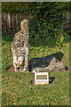
The Hob Stone is a weathered sculptured stone depicting a knight, and once had an inscription on the back which read:
This image Long
Hob's name has bore
Who was a Knight
in time of yore
and gave this
Common to ye poor
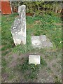
Next to the Hob Stone is a 17th c plague stone.
You may be viewing yesterday's version of this page. To see the most up to date information please register for a free account.
Do not use the above information on other web sites or publications without permission of the contributor.
Nearby Images from Geograph Britain and Ireland:
©2017(licence)
©2021(licence)
©2017(licence)
©2010(licence)
©2010(licence)
The above images may not be of the site on this page, they are loaded from Geograph.
Please Submit an Image of this site or go out and take one for us!
Click here to see more info for this site
Nearby sites
Key: Red: member's photo, Blue: 3rd party photo, Yellow: other image, Green: no photo - please go there and take one, Grey: site destroyed
Download sites to:
KML (Google Earth)
GPX (GPS waypoints)
CSV (Garmin/Navman)
CSV (Excel)
To unlock full downloads you need to sign up as a Contributory Member. Otherwise downloads are limited to 50 sites.
Turn off the page maps and other distractions
Nearby sites listing. In the following links * = Image available
1.5km NE 46° St Mary Bishophill Junior* Ancient Cross (SE5999751471)
1.7km E 82° Pikeing Well Holy Well or Sacred Spring (SE6057650665)
1.9km NE 48° York Roman remains* Ancient Village or Settlement (SE603517)
2.0km NE 52° Jorvik Viking Centre Museum (SE6044451645)
2.0km E 99° Fulford Cross* Ancient Cross (SE6086750131)
2.0km NNE 30° Yorkshire Museum* Museum (SE599522)
2.3km NE 39° York Minster* Museum (SE6032252180)
2.3km NE 40° St Peter's Well (York Minster) Holy Well or Sacred Spring (SE60385219)
2.4km NNE 17° The Burton Stone Ancient Cross (SE5960252718)
2.6km E 79° Lamel Hill Round Barrow(s) (SE6144450947)
3.3km E 82° Siwards How Round Barrow(s) (SE6218450899)
8.4km ENE 76° Dunnington Village Cross Ancient Cross (SE6703052591)
8.8km ENE 64° Holtby Timber Circle (SE668543)
11.3km W 271° St Helen's Church (Bilton-in-Ainsty)* Ancient Cross (SE476504)
12.5km SW 222° St John the Baptist (Kirkby Wharfe) Ancient Cross (SE50604107)
12.9km E 79° Catton Cursus (SE716530)
13.5km ENE 78° Catton Cursus (SE721534)
13.8km SSE 157° Danes Hills (Riccall) Barrow Cemetery (SE6440837723)
14.0km WSW 248° Newton Kyme Henge Henge (SE45934499)
14.5km WSW 252° St Helen's Well (Boston Spa)* Holy Well or Sacred Spring (SE45134583)
17.4km NW 305° Little Ouseburn Barrow Round Barrow(s) (SE445602)
17.9km SW 219° Saxton Church Ancient Cross (SE478364)
19.7km SSW 212° Sherburn Cross* Ancient Cross (SE488335)
20.0km W 273° Green Howe (North Deighton) Round Barrow(s) (SE38865124)
20.3km WSW 258° Collingham Crosses* Ancient Cross (SE3901546096)
View more nearby sites and additional images


 We would like to know more about this location. Please feel free to add a brief description and any relevant information in your own language.
 Wir möchten mehr über diese Stätte erfahren. Bitte zögern Sie nicht, eine kurze Beschreibung und relevante Informationen in Deutsch hinzuzufügen.
 Nous aimerions en savoir encore un peu sur les lieux. S'il vous plaît n'hesitez pas à ajouter une courte description et tous les renseignements pertinents dans votre propre langue.
 Quisieramos informarnos un poco más de las lugares. No dude en añadir una breve descripción y otros datos relevantes en su propio idioma.