


<< Our Photo Pages >> Bicester Stone Circle - Modern Stone Circle etc in England in Oxfordshire
Submitted by BarryC on Friday, 26 August 2022 Page Views: 1773
Modern SitesSite Name: Bicester Stone Circle Alternative Name: Bicester FieldsCountry: England
NOTE: This site is 3.559 km away from the location you searched for.
County: Oxfordshire Type: Modern Stone Circle etc
Nearest Town: Oxford Nearest Village: Bicester
Map Ref: SP588217
Latitude: 51.890761N Longitude: 1.14699W
Condition:
| 5 | Perfect |
| 4 | Almost Perfect |
| 3 | Reasonable but with some damage |
| 2 | Ruined but still recognisable as an ancient site |
| 1 | Pretty much destroyed, possibly visible as crop marks |
| 0 | No data. |
| -1 | Completely destroyed |
| 5 | Superb |
| 4 | Good |
| 3 | Ordinary |
| 2 | Not Good |
| 1 | Awful |
| 0 | No data. |
| 5 | Can be driven to, probably with disabled access |
| 4 | Short walk on a footpath |
| 3 | Requiring a bit more of a walk |
| 2 | A long walk |
| 1 | In the middle of nowhere, a nightmare to find |
| 0 | No data. |
| 5 | co-ordinates taken by GPS or official recorded co-ordinates |
| 4 | co-ordinates scaled from a detailed map |
| 3 | co-ordinates scaled from a bad map |
| 2 | co-ordinates of the nearest village |
| 1 | co-ordinates of the nearest town |
| 0 | no data |
Internal Links:
External Links:
")
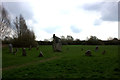
This is a modern stone circle, not a recreation. Construction date unknown, currently trying to find further details. Assumed to be created in the 1990's, or possibly a 'millenium project'.
A short walk from "Bicester Village" railway station - also accessible readily by car, and then a very short walk into a recreation ground. Can also be found and viewed on Stret View with a 360º view of the stone circle available there.
One large central stone surrounded by a circle of c. 17 smaller upright stones.
You may be viewing yesterday's version of this page. To see the most up to date information please register for a free account.
Do not use the above information on other web sites or publications without permission of the contributor.
Nearby Images from Geograph Britain and Ireland:
©2017(licence)
©2016(licence)
©2021(licence)
©2019(licence)
©2021(licence)
The above images may not be of the site on this page, they are loaded from Geograph.
Please Submit an Image of this site or go out and take one for us!
Click here to see more info for this site
Nearby sites
Key: Red: member's photo, Blue: 3rd party photo, Yellow: other image, Green: no photo - please go there and take one, Grey: site destroyed
Download sites to:
KML (Google Earth)
GPX (GPS waypoints)
CSV (Garmin/Navman)
CSV (Excel)
To unlock full downloads you need to sign up as a Contributory Member. Otherwise downloads are limited to 50 sites.
Turn off the page maps and other distractions
Nearby sites listing. In the following links * = Image available
1.3km WNW 297° Bicester Burial Mounds Barrow Cemetery (SP576223)
9.3km NW 313° Somerton Turf Maze (SP5187927901)
13.2km W 281° Hoar Stone at Barton* Long Barrow (SP458241)
14.5km NNW 335° Rainsborough Camp* Hillfort (SP526348)
14.6km E 80° Botyl Well* Holy Well or Sacred Spring (SP732245)
15.2km SW 231° Yarnton* Ancient Village or Settlement (SP4712)
15.6km NE 41° St Rumwald's Well* Holy Well or Sacred Spring (SP690335)
16.0km WSW 252° Fair Rosamund's Well* Holy Well or Sacred Spring (SP43651646)
16.4km WSW 259° Blenheim Great Park Ancient Village or Settlement (SP427183)
16.4km SSW 207° Pitt Rivers Museum* Museum (SP51510695)
16.5km SSW 209° Radcliffe Infirmary prehistoric monumental landscape Round Barrow(s) (SP5103607101)
16.6km W 264° Glympton Farm Ancient Village or Settlement (SP423197)
16.6km SSW 208° Kendrew Quadrangle* Henge (SP51200695)
16.6km ENE 78° Sionhill Farm Henge (SP75012541)
16.6km SSW 211° Walton Well* Holy Well or Sacred Spring (SP5047907312)
16.7km NNW 331° Astrop Well* Holy Well or Sacred Spring (SP50603624)
16.8km NNW 332° St Rumbald's Well* Holy Well or Sacred Spring (SP50783651)
17.0km SSW 207° Ashmolean Museum of Art and Archaeology* Museum (SP511065)
17.1km SSW 199° St Bartholomew's Well Holy Well or Sacred Spring (SP5349805476)
17.1km SW 217° St Margaret's Well (Binsey)* Holy Well or Sacred Spring (SP486080)
17.3km SE 132° Stock Well (Chearsley)* Holy Well or Sacred Spring (SP718103)
17.3km SSW 206° Museum of Oxford* Museum (SP513061)
17.4km W 270° Grimsdyke Farm Ancient Village or Settlement (SP41402141)
17.4km WNW 301° Ilbury Camp* Hillfort (SP438305)
17.5km W 268° Out Wood & Berrings Wood Ancient Village or Settlement (SP413208)
View more nearby sites and additional images


 We would like to know more about this location. Please feel free to add a brief description and any relevant information in your own language.
 Wir möchten mehr über diese Stätte erfahren. Bitte zögern Sie nicht, eine kurze Beschreibung und relevante Informationen in Deutsch hinzuzufügen.
 Nous aimerions en savoir encore un peu sur les lieux. S'il vous plaît n'hesitez pas à ajouter une courte description et tous les renseignements pertinents dans votre propre langue.
 Quisieramos informarnos un poco más de las lugares. No dude en añadir una breve descripción y otros datos relevantes en su propio idioma.