 with our Megalithic Portal iPhone app")


<< Our Photo Pages >> Fulford Cross - Ancient Cross in England in Yorkshire (North)
Submitted by coin on Thursday, 30 March 2017 Page Views: 3263
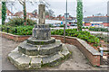
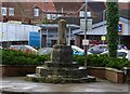
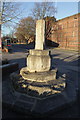
Early Medieval (Dark Age)Site Name: Fulford CrossCountry: England County: Yorkshire (North) Type: Ancient Cross
Nearest Town: York Nearest Village: Fulford
Map Ref: SE6086750131
Latitude: 53.943717N Longitude: 1.074188W
Condition:
| 5 | Perfect |
| 4 | Almost Perfect |
| 3 | Reasonable but with some damage |
| 2 | Ruined but still recognisable as an ancient site |
| 1 | Pretty much destroyed, possibly visible as crop marks |
| 0 | No data. |
| -1 | Completely destroyed |
| 5 | Superb |
| 4 | Good |
| 3 | Ordinary |
| 2 | Not Good |
| 1 | Awful |
| 0 | No data. |
| 5 | Can be driven to, probably with disabled access |
| 4 | Short walk on a footpath |
| 3 | Requiring a bit more of a walk |
| 2 | A long walk |
| 1 | In the middle of nowhere, a nightmare to find |
| 0 | No data. |
| 5 | co-ordinates taken by GPS or official recorded co-ordinates |
| 4 | co-ordinates scaled from a detailed map |
| 3 | co-ordinates scaled from a bad map |
| 2 | co-ordinates of the nearest village |
| 1 | co-ordinates of the nearest town |
| 0 | no data |
Internal Links:
External Links:
I have visited· I would like to visit
coin has visited here
")
From the listing entry:
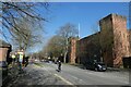
"The monument includes a medieval cross at Fulford, which is situated on the west side of Fulford Road, south west of the barracks. The cross, which is listed Grade II, dates from c.1484. It includes the lower portion of the cross shaft, which is octagonal in section and survives to a height of 1m. This is set into an octagonal base measuring 0.75m high, which itself is set upon a tier of three stone steps, all octagonal in shape."
Read More at Historic England
You may be viewing yesterday's version of this page. To see the most up to date information please register for a free account.
Do not use the above information on other web sites or publications without permission of the contributor.
Nearby Images from Geograph Britain and Ireland:
©2023(licence)
©2024(licence)
©2010(licence)
©2024(licence)
©2021(licence)
The above images may not be of the site on this page, they are loaded from Geograph.
Please Submit an Image of this site or go out and take one for us!
Click here to see more info for this site
Nearby sites
Key: Red: member's photo, Blue: 3rd party photo, Yellow: other image, Green: no photo - please go there and take one, Grey: site destroyed
Download sites to:
KML (Google Earth)
GPX (GPS waypoints)
CSV (Garmin/Navman)
CSV (Excel)
To unlock full downloads you need to sign up as a Contributory Member. Otherwise downloads are limited to 50 sites.
Turn off the page maps and other distractions
Nearby sites listing. In the following links * = Image available
607m NNW 332° Pikeing Well Holy Well or Sacred Spring (SE6057650665)
998m NE 36° Lamel Hill Round Barrow(s) (SE6144450947)
1.5km ENE 60° Siwards How Round Barrow(s) (SE6218450899)
1.6km NNW 345° Jorvik Viking Centre Museum (SE6044451645)
1.6km NNW 328° St Mary Bishophill Junior* Ancient Cross (SE5999751471)
1.7km NNW 341° York Roman remains* Ancient Village or Settlement (SE603517)
2.0km W 279° The Hob Stone* Sculptured Stone (SE5891450417)
2.1km NNW 347° St Peter's Well (York Minster) Holy Well or Sacred Spring (SE60385219)
2.1km NNW 346° York Minster* Museum (SE6032252180)
2.3km NNW 336° Yorkshire Museum* Museum (SE599522)
2.9km NNW 335° The Burton Stone Ancient Cross (SE5960252718)
6.6km ENE 69° Dunnington Village Cross Ancient Cross (SE6703052591)
7.2km NE 56° Holtby Timber Circle (SE668543)
11.1km ENE 76° Catton Cursus (SE716530)
11.7km ENE 74° Catton Cursus (SE721534)
12.9km SSE 165° Danes Hills (Riccall) Barrow Cemetery (SE6440837723)
13.2km W 272° St Helen's Church (Bilton-in-Ainsty)* Ancient Cross (SE476504)
13.7km SW 229° St John the Baptist (Kirkby Wharfe) Ancient Cross (SE50604107)
15.8km WSW 252° Newton Kyme Henge Henge (SE45934499)
16.3km WSW 255° St Helen's Well (Boston Spa)* Holy Well or Sacred Spring (SE45134583)
18.9km SW 224° Saxton Church Ancient Cross (SE478364)
19.2km WNW 302° Little Ouseburn Barrow Round Barrow(s) (SE445602)
20.1km ESE 120° Lady Well (Seaton Ross) Holy Well or Sacred Spring (SE784403)
20.5km SW 217° Sherburn Cross* Ancient Cross (SE488335)
21.8km SW 234° St Ricarius (Aberford) Ancient Cross (SE4331037170)
View more nearby sites and additional images


 We would like to know more about this location. Please feel free to add a brief description and any relevant information in your own language.
 Wir möchten mehr über diese Stätte erfahren. Bitte zögern Sie nicht, eine kurze Beschreibung und relevante Informationen in Deutsch hinzuzufügen.
 Nous aimerions en savoir encore un peu sur les lieux. S'il vous plaît n'hesitez pas à ajouter une courte description et tous les renseignements pertinents dans votre propre langue.
 Quisieramos informarnos un poco más de las lugares. No dude en añadir una breve descripción y otros datos relevantes en su propio idioma.