Featured: Hare and Tabor T Shirts for discerning antiquarians

Hare and Tabor T Shirts for discerning antiquarians

Britain BC

Britain BC

Who's Online

There are currently, 372 guests and 2 members online.

You are a guest. To join in, please register for free by clicking here

Sponsors

<< Our Photo Pages >> Coate Moor - Round Barrow(s) in England in Yorkshire (North)

Submitted by Anne T on Wednesday, 04 May 2016  Page Views: 2371

Neolithic and Bronze AgeSite Name: Coate Moor Alternative Name: Nanny Howe
Country: England
NOTE: This site is 1.273 km away from the location you searched for.

County: Yorkshire (North) Type: Round Barrow(s)
Nearest Town: Stokesley  Nearest Village: Kildale
Map Ref: NZ59841025
Latitude: 54.484077N  Longitude: 1.077878W
Condition:
5Perfect
4Almost Perfect
3Reasonable but with some damage
2Ruined but still recognisable as an ancient site
1Pretty much destroyed, possibly visible as crop marks
0No data.
-1Completely destroyed
2 Ambience:
5Superb
4Good
3Ordinary
2Not Good
1Awful
0No data.
4 Access:
5Can be driven to, probably with disabled access
4Short walk on a footpath
3Requiring a bit more of a walk
2A long walk
1In the middle of nowhere, a nightmare to find
0No data.
3 Accuracy:
5co-ordinates taken by GPS or official recorded co-ordinates
4co-ordinates scaled from a detailed map
3co-ordinates scaled from a bad map
2co-ordinates of the nearest village
1co-ordinates of the nearest town
0no data
5

Internal Links:
External Links:

Coate Moor
Coate Moor submitted by johndhunter : Nanny Howe at NZ 59906 10253 – Underneath this tree and its roots are what I believe to be the remnants of Nanny Howe, it is the SE cairn shown on the modern 1:25 OS map. Image taken May 2019. Nanny Howe was the only barrow in the area built mainly of large stones / boulders of which there is plenty of evidence at this location. See the comments section at the bottom of the Coate Moor site page ... (Vote or comment on this photo)
Round Barrows and possible Stone Row / Alignment in Yorkshire (North)

Sited near Captain Cook's monument and just north of the Cleveland Way in North Yorkshire, this stone row is now recorded as destroyed.

Very little is known about this stone row except it was associated with a cairn. The Pastscape record (monument number 27673) says this was originally the site of a cairn with associated stone alignments, possibly dated to the Bronze Age. Whilst these features were recorded on a map in 1956, the monument could not be located in 1962, destroyed by a combination of woodland regrowth and ploughing.

No details have yet been found about the number and size of stones within the alignment. The site, now in the middle of a forest, sits at an altitude of 285 metres.

For further thoughts and information, see johndhunter's comment below.

Update September 2019: What information is known about this row is also summarised on the Stone Rows of Great Britain's entry for Coate Moor. Sandy G estimates this row is centred around NZ 5948 1025.
You may be viewing yesterday's version of this page. To see the most up to date information please register for a free account.

Coate Moor
Coate Moor submitted by johndhunter : Round Barrow at NZ 59878 10283 – This part of Coate Moor is known as Nanny Howe and prior to forestry ploughing and planting in 1956 there were three round barrows in this area, one Nanny Howe itself about 30ft in diameter made up of mainly large stones and boulders and two approx 20ft diameter barrows made up of earth and small stones. I believe this be to one of the 20ft barrows which still... (Vote or comment on this photo)

Coate Moor
Coate Moor submitted by johndhunter : Round Barrow at NZ 59878 10283 – This part of Coate Moor is known as Nanny Howe and prior to forestry ploughing and planting in 1956 there were three round barrows in this area, one Nanny Howe itself about 30ft in diameter made up of mainly large stones and boulders and two approx 20ft diameter barrows made up of earth and small stones. I believe this be to one of the 20ft barrows which still s... (Vote or comment on this photo)

Coate Moor
Coate Moor submitted by johndhunter : Nanny Howe at NZ 59906 10253 – Underneath woodland debris including a tree and its roots is what I believe to be the remnants of Nanny Howe, it is the SE cairn shown on the modern 1:25 OS map. Nanny Howe was the only barrow in the area built mainly of large stones / boulders of which there is evidence (indicated by the arrow in the image) of these at this location, some visible, others if you sc... (Vote or comment on this photo)

Coate Moor
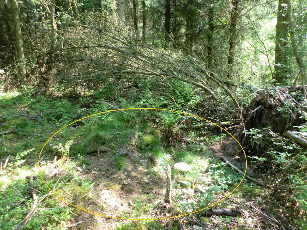
Coate Moor submitted by johndhunter : Nanny Howe at NZ 59906 10253 – Underneath woodland debris including a tree and its roots is what I believe to be the remnants of Nanny Howe, it is the SE cairn shown on the modern 1:25 OS map. Nanny Howe was the only barrow in the area built mainly of large stones / boulders. This view taken May 2019 shows plenty of the smaller stones lying about (within the yellow oval) that would also have mad... (Vote or comment on this photo)

Coate Moor
Coate Moor submitted by johndhunter : Nanny Howe at NZ 59906 10253 – Underneath woodland debris including a tree and its roots is what I believe to be the remnants of Nanny Howe, it is the SE cairn shown on the modern 1:25 OS map. Image taken May 2019. Nanny Howe was the only barrow in the area built mainly of large stones / boulders. See the comments section at the bottom of the Coate Moor site page for my thoughts and observations... (Vote or comment on this photo)

Coate Moor
Coate Moor submitted by johndhunter : Nanny Howe at NZ 59906 10253 – Underneath woodland debris including a tree and its roots is what I believe to be the remnants of Nanny Howe, it is the SE cairn shown on the modern 1:25 OS map. Image taken May 2019. Nanny Howe was the only barrow in the area built mainly of large stones / boulders. See the comments section at the bottom of the Coate Moor site page for my thoughts and observation...

Do not use the above information on other web sites or publications without permission of the contributor.
Click here to see more info for this site

Nearby sites

Click here to view sites on an interactive OS map

Key: Red: member's photo, Blue: 3rd party photo, Yellow: other image, Green: no photo - please go there and take one, Grey: site destroyed

Download sites to:
KML (Google Earth)
GPX (GPS waypoints)
CSV (Garmin/Navman)
CSV (Excel)

To unlock full downloads you need to sign up as a Contributory Member. Otherwise downloads are limited to 50 sites.

Stone Rows of Great Britain by Sandy Gerrard


Turn off the page maps and other distractions

Nearby sites listing. In the following links * = Image available
 1.0km N 355° Great Ayton Moor HC2* Ancient Village or Settlement (NZ5973611291)
 1.1km N 3° Great Ayton Moor HC1* Ancient Village or Settlement (NZ5987711340)
 1.1km NNW 331° Great Ayton Moor HC3* Ancient Village or Settlement (NZ5927311231)
 1.3km NNW 342° Great Ayton Moor Chambered Cairn* Cairn (NZ5939811514)
 1.7km N 7° Great Ayton Moor Cairns 2* Cairn (NZ6003611926)
 1.7km NE 42° Percy Cross Rigg Settlement* Ancient Village or Settlement (NZ6099911551)
 1.8km NNE 28° Percy Cross and Bowl Barrow* Ancient Cross (NZ6067411848)
 2.1km ENE 64° Percy Rigg* Standing Stone (Menhir) (NZ61761120)
 2.2km N 357° Newton Moor RC2* Round Cairn (NZ5971312441)
 2.2km N 360° Newton Moor RC1* Round Cairn (NZ5979412448)
 2.3km N 355° Newton Moor RC3* Round Cairn (NZ5962812494)
 2.3km N 355° Newton Moor RC4* Round Cairn (NZ5962612519)
 2.3km SE 144° Warren Moor* Rock Art (NZ61240836)
 2.4km NNE 34° Codhill Slack* Ring Cairn (NZ6112812241)
 2.4km N 353° Newton Moor RC5* Round Cairn (NZ5951412666)
 2.5km N 353° Newton Moor RC6 & RC7* Round Cairn (NZ5948612730)
 2.8km NNW 344° Pinchinthorpe Moor tumuli* Cairn (NZ5900612945)
 2.9km NNE 33° Codhill Heights* Round Barrow(s) (NZ6136812677)
 3.0km NW 321° Roseberry Topping* Natural Stone / Erratic / Other Natural Feature (NZ5791012603)
 3.3km NNW 349° Hanging Stone (Hutton Lowcross Woods)* Rock Outcrop (NZ5914713460)
 3.5km SSE 162° Battersby Bank Round Barrow* Round Barrow(s) (NZ6099106907)
 3.7km SSE 167° Battersby Bank Cross Dyke* Misc. Earthwork (NZ6075006650)
 3.7km SE 131° Baysdale Pillar Cairn* Cairn (NZ6269407828)
 3.8km NE 51° Pretty Hut Howe* Round Barrow(s) (NZ6278412680)
 3.9km ENE 76° Whiteley Crag RB1* Round Barrow(s) (NZ6366311232)
View more nearby sites and additional images

<< The Tryfel Stones

Kumano Jinja shrine (in Tottori) >>

Please add your thoughts on this site

Prehistoric Rock Art in the Northern Dales

Prehistoric Rock Art in the Northern Dales

Web Links for Coate Moor

Stone Rows of Great Britain by Sandy Gerrard

Sponsors

Auto-Translation (Google)

Translate from English into:

"Coate Moor" | Login/Create an Account | 14 News and Comments
  
Go back to top of page    Comments are owned by the poster. We aren't responsible for their content.
Re: Coate Moor by johndhunter on Thursday, 30 July 2020
(User Info | Send a Message)
Admin : Alternate name is Nanny Howe
[ Reply to This ]

Re: Coate Moor by johndhunter on Saturday, 21 September 2019
(User Info | Send a Message)
Regarding the September update in the description stating that SandyG estimates that the stone row is centred around NZ 5948 1025 , this is also Pastscapes grid ref - read my comment on the 18th March 2019 where I explain why this is incorrect. Also read my comment on the 24th May 2019 regarding where I believe Nanny How and the adjacent round barrows are - It is somewhere near here the stone row will have been - NZ 5948 1025 is incorrect
[ Reply to This ]

Re: Coate Moor by johndhunter on Sunday, 26 May 2019
(User Info | Send a Message)
Admin: Condition is 2, Ambience 4, Access 3
[ Reply to This ]

Re: Coate Moor by johndhunter on Friday, 24 May 2019
(User Info | Send a Message)
Admin: Suggestion that the Type be changed to round barrows this I believe would be a more accurate representation of the site
[ Reply to This ]
    Re: Coate Moor by Sunny100 on Friday, 24 May 2019
    (User Info | Send a Message)
    Thanks, now up-dated to Round Barrows. Anne you might want to take a look at this site, and see if other changes are needed in light of what johndhunter says. Thanks.
    [ Reply to This ]
      Re: Coate Moor by johndhunter on Saturday, 25 May 2019
      (User Info | Send a Message)
      Now that site type has been changed I will upload some photos that I have taken in the next couple of days showing the evidence of what I have found as regards the barrows . Though I could not get any real overall views because its all in dense woodland. However they do show the evidence for the site of what I am pretty sure is Nanny Howe which Pastscape and others think is destroyed
      [ Reply to This ]

Re: Coate Moor by johndhunter on Friday, 24 May 2019
(User Info | Send a Message)
Update: The exact location of Nanny Howe is bugging me, destroyed by ploughing or not. As it was made of large stones or boulders there should be lots of evidence in the area where it once stood. Consequently I paid another visit to the area this time making a concerted effort to approach the cairn shown on the os map at at NZ 59904 10251 and though covered by a large fallen tree including the huge root, as well as other debris I managed to work my way amongst it all. The result being that this is almost certainly the remains of Nanny Howe with numerous boulders and stones present, a lot of them not immediately evident but once you start scraping away the lichen etc. you start to see the stone underneath. Though difficult to ascertain its size because of the debris it will be about 30 ft across. It looks like the plough went either side on its perimeter so I would imagine if all the debris and vegetation were removed it would reveal a substantial part of the barrow is still there, certainly not totally destroyed.

Whilst I was in the area prior to checking out the barrow above I double checked the area Pastscape Monument 27667. which gives the grid reference for Nanny Howe itself as NZ 5977 1028. I stand by previous comment of the 4th of May 2019 this is not the location of Nanny Howe or any other barrow for that matter and the grid reference given was probably incorrect from the original source (didn’t have gps in the 1950’s)

Final Conclusion: The remains of Nanny Howe itself at NZ 59906 10253 (my gps) and one of its two adjacent 20ft round barrows at NZ 59878 10283 (my gps) are still visible and are the two cairns shown on the modern 1:25 OS map. The 20ft barrow looks to be wholly intact, with the plough going either side of it and a substantial part of Nanny Howe looks to be still intact, maybe most of it, difficult to say until all the debris is removed from the top of it. One thing is for sure Nanny Howe was not totally destroyed by the ploughing,

[ Reply to This ]

Re: Coate Moor by johndhunter on Saturday, 04 May 2019
(User Info | Send a Message)
Some additional thoughts and observations: On the ridge known as Nanny Howe at NZ 599103 (this is the grid ref given in the report of the excavation as per my previous comment) were three barrows in close proximity one 30ft in diameter know as Nanny Howe itself and two other barrows 20ft in diameter (plus half a dozen or so smaller cairns). Nanny Howe was constructed of large stones / boulders whilst the two adjoining barrows or mounds as the report calls them were made of earth and small stones and were 20 ft in diameter. Note: The report says they were adjoining so I would venture to say that all features were in grid square NZ 599103 or very close to this as per the report.

An anomaly: Pastscape Monument 27667. gives the grid reference for Nanny Howe itself as NZ 5977 1028. the source being the 1957 six inch OS annotated record map by SV Morris with information provided by R. Close and R.H.Hayes (excavators of Nanny Howe), quite unequivocal one would have thought and yet I am sceptical. Keeping in mind that Nanny Howe was destroyed by deep ploughing, well the deep ploughing stopped just short of this grid reference. You can see this on google earth it looks like they left a strip about 50ft wide or more along this section of what is now the Cleveland Way and the start of the ploughing which runs down the north side of the ridge for the plantation proper. The strip is just a general mixture of woodland and you can see this if you go down to the Cleveland Way in street view. I have had a look in this area (April 2019) and whilst everything is overgrown there are no signs of any of the large boulders or stones that made up Nanny Howe. I believe this grid reference to be incorrect and that Nanny Howe was further to the east.

There are two cairns shown on the modern 1:25 OS map NZ 59878 10283 (my gps) and the other at NZ 59904 10251 (from map). This part of the wooded strip and plantation has been thinned out at some time in the past and most of the debris just left as is with fallen trees etc, making parts of it nigh on impenetrable. I could not tell whether there was a cairn at NZ 59904 10251 or not, it was covered with a large fallen tree and other debris I could not get close enough. Working my way around and behind this from the Cleveland Way heading for the site of the other cairn at NZ 59878 10283 the deep ploughing that had occurred is very evident and what I noticed was the numerous large stones that had been turned up by the plough and deposited on the ridges including a particularly large boulder at NZ 59912 10277. Eventually reaching the site of the cairn shown on the map at NZ 59878 10283 covered in bilberry plants (always a good sign that you have found a barrow, why I don’t know) and woodland debris from the thinning it looks to be still intact and is about 20ft across which fits the description of one of the two mounds adjoining Nanny Howe. Note: Though I did not know it at the time there is a trail which runs past the barrow from the Cleveland Way, starting at NZ 59808 10259 .

Though the grid references differ (though they are all quite close) I strongly suspect that the two cairns shown on the map are in fact those cairns listed on Pastscape as Pastscape Monument 27673 - which is this site page (grid ref NZ 5984 1025) and Pastscape Monument 27670 (grid ref NZ 5992 1028).

Conclusion: At least one of the two 20ft barrows which adjoined Nanny Howe is still intact this is at NZ 59878 10283, there is a possibility that it is in fact the cairn o

Read the rest of this post...
[ Reply to This ]

Re: Coate Moor by johndhunter on Monday, 18 March 2019
(User Info | Send a Message)
Some thoughts and observations on this alignment - It would appear that the grid reference given is not correct Pastscape Monument 27673 under the sub heading “Detail” gives the location as NZ 5948 1025 consequently this is then given as the map reference on this site page. However in Pastscape if you look under the sub heading “More Sources and Information” you will see the following statement” “(NZ 59841025) 20ft diameter cairn, 2-3ft high, with parallel lines of stones leading to it. Damaged by ploughing.” So it looks like Pastscape have inadvertently mixed up the 8 & 4 in the Easting Map reference when they typed up the location and the correct grid reference should read NZ 5984 1025 which makes a big difference to where it actually was and also puts it with the other cairns on Coate Moor.

The modern OS map shows two cairns one at NZ 59872 10278 and the other at NZ 59904 10251 (grid references from map). The grid reference NZ 5984 1025 puts the cairn/alignment just to the west of these so that they form a triangular shape, they are all close enough together that their six figure grid reference is the same NZ 599 103. One of these cairns was known as Nanny Howe named after a well known local witch. None of the old OS maps show any of these cairns specifically, though they do show the name Nanny Howe on the ridge and interestingly the 1895 OS map calls this Court Moor rather than Coate Moor.

This area was/is known locally as the Devils Court. Frank and Harriet Wragg Elgee in their 1933 book “The Archaeology of Yorkshire” page 89 surmise that “Our witch-lore is directly associated with Bronze Age settlement sites” they then go on to say and I quote “We tested this association recently. Half a mile east of Captain Cooks Monument (an obelisk) on Easby Moor is the Devils Court, where according to tradition witches congregated under the presidency of their lord and master. We therefore examined the Court and found what we expected, a typical moorland Bronze Age settlement site, with stone walled enclosures, shallow pits, flint implements, and many barrows one of which is named Nanny Howe, after a famous witch” They do not mention any alignment, though they do mention stone walls?

Pastscape in their description of this site says this alignment is mentioned in a number of sources and yet only quote the one by R.H.Hayes. Who these other sources are I do not know because I can’t find any. R.H. Hayes was a highly respected North East Yorkshire Archaeologist (though actually a photographer by profession) who was the local correspondent for the Ordnance Survey for which he received an MBE in 1966. Local correspondents were a country wide network of volunteers who recorded and reported upon archaeological finds. Consequently Hayes annotated the 1956 6 inch OS map with information regarding the cairn and alignment as described in the first paragraph.

In 1956 prior to heavy ploughing and planting by the forestry commission Hayes and others obtained permission to excavate Nanny Howe, he describes the location as follows. “Even before Forestry Commission ploughing and planting in May 1956 there was little trace of the settlement. On the 6 inch OS map only the name Nanny Howe appeared, The Howe itself was not marked nor were the other two close by, nor the 6-8 small stony cairns in the vicinity. When ploughing did take place it revealed no signs of walling” He makes no mention of the alignment whatsoever. The source of the above information is a part of a description of the excavation of Nanny Howe in the 1966 Yorkshire Archaeological Journal Volume 41 Pages 577 – 581 and can be read HERE.

Note: In the above Journal he describes Nanny Howe as being 30ft in diameter and 3ft high so it is not the cairn with the alignment described in pastscape and must in fact be one of the cairns shown on the mod

Read the rest of this post...
[ Reply to This ]
    Re: Coate Moor by Anne T on Monday, 18 March 2019
    (User Info | Send a Message)
    Hello, johndhunter. Many thanks for your detailed comment and thoughts. This page was created to try and make sense of some of the many sites in and around here from a series of photos that was submitted, but without having visited and seen what was actually on the ground, it was a little tricky. What you say makes great sense and the modern OS map, and the map on the HE website, do indeed show two cairns at the grid references you give.

    Have you let Pastscape know about the error they've made in transposing two numbers in the grid reference for this site? There is a mechanism for giving them feedback like this, which is much appreciated by them.
    [ Reply to This ]
      Re: Coate Moor by johndhunter on Tuesday, 19 March 2019
      (User Info | Send a Message)
      Hi Anne: Tried submitting information to Pastscape but kept getting error message "An error has occurred. We apologise for any inconvenience this has caused." so gave up in the end
      [ Reply to This ]
        Re: Coate Moor by Anne T on Tuesday, 19 March 2019
        (User Info | Send a Message)
        Hello, John. Many thanks for replying. I had problems getting onto Pastscape this morning, but was finally able to submit them a message, directing them to this site page and your comment, saying two of the numbers had been transposed. Hope you didn't mind me doing this. I'll let you know if there's any response. Thanks for correcting this - much appreciate!
        [ Reply to This ]

Your Name: Anonymous [ Register Now ]
Subject:


Add your comment or contribution to this page. Spam or offensive posts are deleted immediately, don't even bother

<<< What is five plus one as a number? (Please type the answer to this question in the little box on the left)
You can also embed videos and other things. For Youtube please copy and paste the 'embed code'.
For Google Street View please include Street View in the text.
Create a web link like this: <a href="https://www.megalithic.co.uk">This is a link</a>  

Allowed HTML is:
<p> <b> <i> <a> <img> <em> <br> <strong> <blockquote> <tt> <li> <ol> <ul> <object> <param> <embed> <iframe>

We would like to know more about this location. Please feel free to add a brief description and any relevant information in your own language.
Wir möchten mehr über diese Stätte erfahren. Bitte zögern Sie nicht, eine kurze Beschreibung und relevante Informationen in Deutsch hinzuzufügen.
Nous aimerions en savoir encore un peu sur les lieux. S'il vous plaît n'hesitez pas à ajouter une courte description et tous les renseignements pertinents dans votre propre langue.
Quisieramos informarnos un poco más de las lugares. No dude en añadir una breve descripción y otros datos relevantes en su propio idioma.