

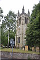
<< Our Photo Pages >> All Saints (Helmsley) - Early Christian Sculptured Stone in England in Yorkshire (North)
Submitted by TimPrevett on Monday, 21 May 2007 Page Views: 5307
Early Medieval (Dark Age)Site Name: All Saints (Helmsley)Country: England
NOTE: This site is 0.139 km away from the location you searched for.
County: Yorkshire (North) Type: Early Christian Sculptured Stone
Nearest Village: Helmsley
Map Ref: SE61188387
Latitude: 54.246870N Longitude: 1.062611W
Condition:
| 5 | Perfect |
| 4 | Almost Perfect |
| 3 | Reasonable but with some damage |
| 2 | Ruined but still recognisable as an ancient site |
| 1 | Pretty much destroyed, possibly visible as crop marks |
| 0 | No data. |
| -1 | Completely destroyed |
| 5 | Superb |
| 4 | Good |
| 3 | Ordinary |
| 2 | Not Good |
| 1 | Awful |
| 0 | No data. |
| 5 | Can be driven to, probably with disabled access |
| 4 | Short walk on a footpath |
| 3 | Requiring a bit more of a walk |
| 2 | A long walk |
| 1 | In the middle of nowhere, a nightmare to find |
| 0 | No data. |
| 5 | co-ordinates taken by GPS or official recorded co-ordinates |
| 4 | co-ordinates scaled from a detailed map |
| 3 | co-ordinates scaled from a bad map |
| 2 | co-ordinates of the nearest village |
| 1 | co-ordinates of the nearest town |
| 0 | no data |
Internal Links:
External Links:
I have visited· I would like to visit
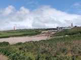
Anne T visited on 10th Oct 2014 - their rating: Cond: 2 Amb: 2 Access: 5 All Saints (Helmsley) (Hogback Tomb Remanant): We last visited Helmsley on 19th August 2010 (was it really so long ago?) as we’d heard a lot about this attractive little town but never been. There was an event on at the castle and the place was totally overrun with tourists. After a cup of tea and a visit to the church, we escaped gratefully.
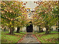
This time, it was very different. It was half past four and the town was quiet. The church is open until 5pm, so we went in search of the hogback fragment in the porch.
It sits on its own on the east wall of the porch, tucked away as an almost forgotten remnant behind the gates to the porch. At first, it’s almost not recognisable as a hogback, particularly as the simple rectangular interlaced pattern was so reminiscent of the Anglo Saxon cross shaft we’d seen built into the wall at St. Gregory’s Minster earlier today. The stone looks as if it has been completely hacked about and is now a ragged rectangular shape. I had to come back and read my ‘Grammar of Anglo-Saxon Ornament’ by Rosemary Cramp to see what shape it might have been to start with.
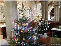
For anyone planning to visit the church, the wall paintings, whilst modern, are impressive. It has a lovely atmosphere and there are various stations around the church were candles are burning in remembrance.
There was no guide book, but I have an address to send away for one, and there is quite a bit of history about the church on the Helmsley Parish web site.
kelpie have visited here
 (PID:75188)")
Early 10th Century Hogback tombstone in the porch at All Saints', Helmsley.
You may be viewing yesterday's version of this page. To see the most up to date information please register for a free account.
 (PID:126213)")
 (PID:126212)")
 (PID:75189)")
Do not use the above information on other web sites or publications without permission of the contributor.
Nearby Images from Geograph Britain and Ireland:
©2011(licence)
©2019(licence)
©2023(licence)
©2023(licence)

©2023(licence)
The above images may not be of the site on this page, they are loaded from Geograph.
Please Submit an Image of this site or go out and take one for us!
Click here to see more info for this site
Nearby sites
Key: Red: member's photo, Blue: 3rd party photo, Yellow: other image, Green: no photo - please go there and take one, Grey: site destroyed
Download sites to:
KML (Google Earth)
GPX (GPS waypoints)
CSV (Garmin/Navman)
CSV (Excel)
To unlock full downloads you need to sign up as a Contributory Member. Otherwise downloads are limited to 50 sites.
Turn off the page maps and other distractions
Nearby sites listing. In the following links * = Image available
2.6km WSW 245° Buckland's Windypit Cave or Rock Shelter (SE588827)
3.1km WSW 253° Ashberry windypit* Cave or Rock Shelter (SE582829)
3.1km WSW 253° Antofts windypit Cave or Rock Shelter (SE582829)
3.5km W 266° Slip Gill windypit Cave or Rock Shelter (SE577836)
5.0km S 170° St Oswald (Oswaldkirk)* Ancient Cross (SE62107892)
5.0km SW 218° Studfold Ring (Ampleforth)* Ancient Village or Settlement (SE5812279855)
6.8km ENE 74° Kirkdale Sundial* Early Christian Sculptured Stone (SE6768885776)
6.8km ENE 76° Kirkdale Hyena Cave* Cave or Rock Shelter (SE678856)
7.2km SE 133° All Saints and St James (Nunnington) Ancient Cross (SE6657079070)
7.3km WNW 284° Kirby Ley* Round Barrow(s) (SE5408985584)
7.4km SE 144° Stonegrave Minster* Ancient Cross (SE6561077885)
7.5km ENE 67° Robin Hood's Howl Round Barrow(s) (SE68038695)
8.0km WSW 248° Cockerdale Wood Cairn Cairn (SE53838075)
8.5km N 9° Hanging Stone (Pockley Moor)* Standing Stone (Menhir) (SE6241392266)
8.6km NNW 346° Helmsley Moor RB1* Round Barrow(s) (SE5904992216)
9.1km NNW 345° Roppa Cross South* Ancient Cross (SE5872492614)
9.2km E 89° St Michael and All Angels (Great Edstone)* Early Christian Sculptured Stone (SE704842)
9.3km WSW 258° High Town round cairn Cairn (SE52138179)
9.3km NE 52° Kirk Howe Cairn (SE68458975)
9.4km NNW 346° Roppa Cross North* Ancient Cross (SE5869992992)
9.4km NNW 344° Carr Cote Ridge (Laskill Pasture Moor)* Round Barrow(s) (SE5844092920)
9.5km NW 308° All Saints Church, Hawnby* Ancient Cross (SE53658967)
9.6km W 266° Cooper Cross (Sutton Bank)* Ancient Cross (SE5157082994)
9.7km S 187° Gilling Long Cairn* Chambered Cairn (SE6017074185)
9.8km SSE 147° All Saints (Hovingham)* Ancient Cross (SE6665575705)
View more nearby sites and additional images


 We would like to know more about this location. Please feel free to add a brief description and any relevant information in your own language.
 Wir möchten mehr über diese Stätte erfahren. Bitte zögern Sie nicht, eine kurze Beschreibung und relevante Informationen in Deutsch hinzuzufügen.
 Nous aimerions en savoir encore un peu sur les lieux. S'il vous plaît n'hesitez pas à ajouter une courte description et tous les renseignements pertinents dans votre propre langue.
 Quisieramos informarnos un poco más de las lugares. No dude en añadir una breve descripción y otros datos relevantes en su propio idioma.