


<< Our Photo Pages >> Warren Moor - Rock Art in England in Yorkshire (North)
Submitted by vicky on Sunday, 21 July 2002 Page Views: 6091
Rock ArtSite Name: Warren MoorCountry: England
NOTE: This site is 0.228 km away from the location you searched for.
County: Yorkshire (North) Type: Rock Art
Nearest Town: Whitby Nearest Village: Kildale
Map Ref: NZ61240836 Landranger Map Number: 93
Latitude: 54.466927N Longitude: 1.056663W
Condition:
| 5 | Perfect |
| 4 | Almost Perfect |
| 3 | Reasonable but with some damage |
| 2 | Ruined but still recognisable as an ancient site |
| 1 | Pretty much destroyed, possibly visible as crop marks |
| 0 | No data. |
| -1 | Completely destroyed |
| 5 | Superb |
| 4 | Good |
| 3 | Ordinary |
| 2 | Not Good |
| 1 | Awful |
| 0 | No data. |
| 5 | Can be driven to, probably with disabled access |
| 4 | Short walk on a footpath |
| 3 | Requiring a bit more of a walk |
| 2 | A long walk |
| 1 | In the middle of nowhere, a nightmare to find |
| 0 | No data. |
| 5 | co-ordinates taken by GPS or official recorded co-ordinates |
| 4 | co-ordinates scaled from a detailed map |
| 3 | co-ordinates scaled from a bad map |
| 2 | co-ordinates of the nearest village |
| 1 | co-ordinates of the nearest town |
| 0 | no data |
Be the first person to rate this site - see the 'Contribute!' box in the right hand menu.
Internal Links:
External Links:
")
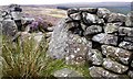
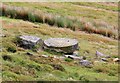
This cup and ring marked stone is recorded as Pastscape Monument No. 28111, which says: "This stone is set into the E side of the wall surmounting Park Dyke at NZ 6124 0836. It is an upright stone 0.7m high, 0.5m wide and 0.2m thick with two incised rings each about 0.1m in diameter. The upper ring is more clearly defined and has a central hole. Neither are 'cup-and-ring' marks. Alongside is another large stone which is roughly incised with a letter R suggesting that both stones may have been boundary markers of some kind." The description on the record reads 'an alleged cup and ring marked stone.' There is no record on the Historic England website.
You may be viewing yesterday's version of this page. To see the most up to date information please register for a free account.
")
")
Do not use the above information on other web sites or publications without permission of the contributor.
Nearby Images from Geograph Britain and Ireland:
©2006(licence)
©2005(licence)
©2007(licence)
©2020(licence)
©2010(licence)
The above images may not be of the site on this page, they are loaded from Geograph.
Please Submit an Image of this site or go out and take one for us!
Click here to see more info for this site
Nearby sites
Key: Red: member's photo, Blue: 3rd party photo, Yellow: other image, Green: no photo - please go there and take one, Grey: site destroyed
Download sites to:
KML (Google Earth)
GPX (GPS waypoints)
CSV (Garmin/Navman)
CSV (Excel)
To unlock full downloads you need to sign up as a Contributory Member. Otherwise downloads are limited to 50 sites.
![]()
Turn off the page maps and other distractions
Nearby sites listing. In the following links * = Image available
1.5km S 190° Battersby Bank Round Barrow* Round Barrow(s) (NZ6099106907)
1.5km ESE 111° Baysdale Pillar Cairn* Cairn (NZ6269407828)
1.8km SSW 197° Battersby Bank Cross Dyke* Misc. Earthwork (NZ6075006650)
2.3km NW 324° Coate Moor* Round Barrow(s) (NZ59841025)
2.7km SE 126° Lamb Stone (Holiday Hill)* Natural Stone / Erratic / Other Natural Feature (NZ6343806835)
2.8km S 173° Baysdale Cross (Middle Head)* Ancient Cross (NZ6163205633)
2.9km N 11° Percy Rigg* Standing Stone (Menhir) (NZ61761120)
3.2km N 356° Percy Cross Rigg Settlement* Ancient Village or Settlement (NZ6099911551)
3.3km NNW 336° Great Ayton Moor HC1* Ancient Village or Settlement (NZ5987711340)
3.3km NNW 334° Great Ayton Moor HC2* Ancient Village or Settlement (NZ5973611291)
3.3km S 176° Cheese Stones* Natural Stone / Erratic / Other Natural Feature (NZ6154405038)
3.4km SSW 211° Mary Ross Seat* Carving (NZ5953405423)
3.5km NNW 326° Great Ayton Moor HC3* Ancient Village or Settlement (NZ5927311231)
3.5km N 352° Percy Cross and Bowl Barrow* Ancient Cross (NZ6067411848)
3.6km NE 46° Commondale Moor Stone Circle* Stone Circle (NZ63791085)
3.6km NNW 331° Great Ayton Moor Chambered Cairn* Cairn (NZ5939811514)
3.8km NE 41° Whiteley Crag RB1* Round Barrow(s) (NZ6366311232)
3.8km NNW 342° Great Ayton Moor Cairns 2* Cairn (NZ6003611926)
3.8km NE 44° Whiteley Crag RB3* Round Barrow(s) (NZ6388511136)
3.8km NE 43° Whiteley Crag RB2* Round Barrow(s) (NZ6384111194)
3.8km NE 46° Whiteley Crag RB4 and Cairn Cemetery* Barrow Cemetery (NZ6398911062)
3.9km N 359° Codhill Slack* Ring Cairn (NZ6112812241)
3.9km NE 42° Commondale Moor North SS1* Standing Stone (Menhir) (NZ6384311338)
4.1km NE 43° Commondale Moor North RB1* Round Barrow(s) (NZ6400111417)
4.2km SSW 192° Hand Stone (Ingleby Moor)* Marker Stone (NZ6041004222)
View more nearby sites and additional images


 We would like to know more about this location. Please feel free to add a brief description and any relevant information in your own language.
 Wir möchten mehr über diese Stätte erfahren. Bitte zögern Sie nicht, eine kurze Beschreibung und relevante Informationen in Deutsch hinzuzufügen.
 Nous aimerions en savoir encore un peu sur les lieux. S'il vous plaît n'hesitez pas à ajouter une courte description et tous les renseignements pertinents dans votre propre langue.
 Quisieramos informarnos un poco más de las lugares. No dude en añadir una breve descripción y otros datos relevantes en su propio idioma.