


<< Our Photo Pages >> Pretty Hut Howe - Round Barrow(s) in England in Yorkshire (North)
Submitted by johndhunter on Tuesday, 23 January 2024 Page Views: 162
Neolithic and Bronze AgeSite Name: Pretty Hut HoweCountry: England
NOTE: This site is 1.229 km away from the location you searched for.
County: Yorkshire (North) Type: Round Barrow(s)
Nearest Town: Guisborough Nearest Village: Hutton Village
Map Ref: NZ6278412680
Latitude: 54.505557N Longitude: 1.031929W
Condition:
| 5 | Perfect |
| 4 | Almost Perfect |
| 3 | Reasonable but with some damage |
| 2 | Ruined but still recognisable as an ancient site |
| 1 | Pretty much destroyed, possibly visible as crop marks |
| 0 | No data. |
| -1 | Completely destroyed |
| 5 | Superb |
| 4 | Good |
| 3 | Ordinary |
| 2 | Not Good |
| 1 | Awful |
| 0 | No data. |
| 5 | Can be driven to, probably with disabled access |
| 4 | Short walk on a footpath |
| 3 | Requiring a bit more of a walk |
| 2 | A long walk |
| 1 | In the middle of nowhere, a nightmare to find |
| 0 | No data. |
| 5 | co-ordinates taken by GPS or official recorded co-ordinates |
| 4 | co-ordinates scaled from a detailed map |
| 3 | co-ordinates scaled from a bad map |
| 2 | co-ordinates of the nearest village |
| 1 | co-ordinates of the nearest town |
| 0 | no data |
Internal Links:
External Links:
")
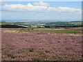
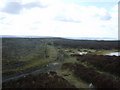
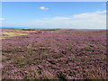
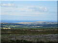
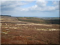
Though unscheduled, the very mutilated remains of this Bronze Age round barrow is still visible. Originally about 12m in diameter it is shown on the present day (2023) OS map, and is marked as a cairn, it stands by a track leading to Sleddale Farm.
Crawford** identified this as Pretty Hut Howe in the late 1970s, it was so called because at one time it had a watchman's hut built upon it. At the time of his investigation it had recently (post 1974) been bulldozed from the south and was now horse shoe shaped, though there were still broken pantiles, glass and wood littering the area when he investigated. This he says accords with ATKINSON’S excavation report in 1864: ‘Pretty Hut Howe was a barrow with a hut, tiled roof and a doorway with post built into it hence the name’. However, Atkinson does not describe it this way in his submission to the July 1864 edition of the Gentleman's Magazine which can be viewed HERE starting second paragraph page 22, he just describes it as a watcher's hut now roofless.
Also and this is where the anomalies start, Atkinson specifically states that the barrow he is opening was one of the stations of the Ordnance Surveyors at 1079ft and as well as the watcher's hut it had a Sappers Cairn (Trig Point?) upon it. This is not this barrow at NZ 62784 12680 designated Pretty Hut Howe by Crawford but this one HERE, my designation Gisborough Moor RB2. Both barrows can be seen HERE on the 1856 OS map. When the map opens go to the top right where it says LAND HILLS (Cleveland Hills) just below the H you will see the barrow with the trig point this is at NZ 63450 12348 whilst the barrow designated Pretty Hut Howe by Crawford is that barrow at the very top of the map next to the L from the word LAND.
Consequently, one would surmise that Crawford has got it wrong however a Field Investigators report in 1974 one of the sources under more information within the HERR MONUMENT 28643 states that the barrow with the recorded* trig point on the 1856 map nowhere near resembles the description of the barrow that Atkinson opened and that the latter appears to be the one at 1050ft NZ 6278 1267 (this one), though the application of the name Pretty Hut Howe could not be confirmed. My layman's view: I can also say that the barrow with the recorded trig point does not match Atkinson's description.
* I note he uses the term recorded, implying to me that other trig points were also used but not recorded. Still it's strange that Atkinson should specifically state that he is opening the barrow at 1079ft with the Sappers Cairn (Trig Point) and roofless watcher's hut on it then describe the opening of what appears to be a different barrow. However, I have seen other anomalies written by Atkinson, including where he describes a barrow being due north of a position when in fact it's due west so perhaps not so strange. Also this would have been all open moorland, no shooters tracks etc. and no GPS, mapping for this area was only eight years old in 1864, so maybe didn’t know (in a modern context) precisely where he actually was at the time.
**Crawford G.M. 1980, “Bronze Age Burial Mounds in Cleveland” SMR 0199 page 39.
You may be viewing yesterday's version of this page. To see the most up to date information please register for a free account.
")
")
Do not use the above information on other web sites or publications without permission of the contributor.
Nearby Images from Geograph Britain and Ireland:
©2023(licence)
©2010(licence)
©2017(licence)
©2021(licence)
©2010(licence)
The above images may not be of the site on this page, they are loaded from Geograph.
Please Submit an Image of this site or go out and take one for us!
Click here to see more info for this site
Nearby sites
Key: Red: member's photo, Blue: 3rd party photo, Yellow: other image, Green: no photo - please go there and take one, Grey: site destroyed
Download sites to:
KML (Google Earth)
GPX (GPS waypoints)
CSV (Garmin/Navman)
CSV (Excel)
To unlock full downloads you need to sign up as a Contributory Member. Otherwise downloads are limited to 50 sites.
Turn off the page maps and other distractions
Nearby sites listing. In the following links * = Image available
475m SE 125° Gisborough Moor RB1* Round Barrow(s) (NZ6318012415)
742m ESE 117° Gisborough Moor RB2* Round Barrow(s) (NZ6345012348)
778m ESE 105° Gisborough Moor RB3* Round Barrow(s) (NZ6354112492)
1.1km E 91° Gisborough Moor RB4* Round Barrow(s) (NZ6391412675)
1.4km W 271° Codhill Heights* Round Barrow(s) (NZ6136812677)
1.5km ESE 116° North Ings Slack RB1* Round Barrow(s) (NZ6419512029)
1.7km SSE 150° Whiteley Crag RB1* Round Barrow(s) (NZ6366311232)
1.7km SE 143° Commondale Moor North SS1* Standing Stone (Menhir) (NZ6384311338)
1.7km WSW 256° Codhill Slack* Ring Cairn (NZ6112812241)
1.8km SE 137° Commondale Moor North RB1* Round Barrow(s) (NZ6400111417)
1.8km E 98° Noth Ings Bride Stones* Stone Row / Alignment (NZ6453212444)
1.8km SW 215° Percy Rigg* Standing Stone (Menhir) (NZ61761120)
1.8km SE 145° Whiteley Crag RB2* Round Barrow(s) (NZ6384111194)
1.8km E 95° Hob on the Hill Cairn 1* Cairn (NZ6461512555)
1.8km E 97° Hob on the Hill Barrow 2* Round Barrow(s) (NZ6462512493)
1.9km E 99° Hob on the Hill Mound* Round Barrow(s) (NZ64641242)
1.9km SE 145° Whiteley Crag RB3* Round Barrow(s) (NZ6388511136)
1.9km ENE 71° Hob Cross (Tidkinhow Head)* Ancient Cross (NZ6458213328)
2.0km SE 144° Whiteley Crag RB4 and Cairn Cemetery* Barrow Cemetery (NZ6398911062)
2.1km SSE 152° Commondale Moor Stone Circle* Stone Circle (NZ63791085)
2.1km WSW 238° Percy Cross Rigg Settlement* Ancient Village or Settlement (NZ6099911551)
2.2km ESE 115° North Ings RB1* Round Barrow(s) (NZ6476011797)
2.3km WSW 249° Percy Cross and Bowl Barrow* Ancient Cross (NZ6067411848)
2.3km E 90° Stanghow High Moor RB1* Round Barrow(s) (NZ6511812694)
2.3km E 100° Skelderskew Moor North West* Marker Stone (NZ6509812325)
View more nearby sites and additional images


 We would like to know more about this location. Please feel free to add a brief description and any relevant information in your own language.
 Wir möchten mehr über diese Stätte erfahren. Bitte zögern Sie nicht, eine kurze Beschreibung und relevante Informationen in Deutsch hinzuzufügen.
 Nous aimerions en savoir encore un peu sur les lieux. S'il vous plaît n'hesitez pas à ajouter une courte description et tous les renseignements pertinents dans votre propre langue.
 Quisieramos informarnos un poco más de las lugares. No dude en añadir una breve descripción y otros datos relevantes en su propio idioma.