


<< Text Pages >> East Tisted Bowl Barrow - Round Barrow(s) in England in Hampshire
Submitted by SolarMegalith on Tuesday, 19 June 2012 Page Views: 2711
Neolithic and Bronze AgeSite Name: East Tisted Bowl BarrowCountry: England
NOTE: This site is 2.542 km away from the location you searched for.
County: Hampshire Type: Round Barrow(s)
Nearest Village: East Tistead
Map Ref: SU70263281
Latitude: 51.090309N Longitude: 0.998159W
Condition:
| 5 | Perfect |
| 4 | Almost Perfect |
| 3 | Reasonable but with some damage |
| 2 | Ruined but still recognisable as an ancient site |
| 1 | Pretty much destroyed, possibly visible as crop marks |
| 0 | No data. |
| -1 | Completely destroyed |
| 5 | Superb |
| 4 | Good |
| 3 | Ordinary |
| 2 | Not Good |
| 1 | Awful |
| 0 | No data. |
| 5 | Can be driven to, probably with disabled access |
| 4 | Short walk on a footpath |
| 3 | Requiring a bit more of a walk |
| 2 | A long walk |
| 1 | In the middle of nowhere, a nightmare to find |
| 0 | No data. |
| 5 | co-ordinates taken by GPS or official recorded co-ordinates |
| 4 | co-ordinates scaled from a detailed map |
| 3 | co-ordinates scaled from a bad map |
| 2 | co-ordinates of the nearest village |
| 1 | co-ordinates of the nearest town |
| 0 | no data |
Internal Links:
External Links:
Round Barrow in Hampshire
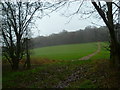
Much reduced remains of a Bronze Age bowl barrow. The tree-planted mound is 0.4 m high.
Read More at Pastscape.
You may be viewing yesterday's version of this page. To see the most up to date information please register for a free account.
Do not use the above information on other web sites or publications without permission of the contributor.
Nearby Images from Geograph Britain and Ireland:
©2016(licence)
©2014(licence)
©2011(licence)
©2015(licence)
©2014(licence)
The above images may not be of the site on this page, they are loaded from Geograph.
Please Submit an Image of this site or go out and take one for us!
Click here to see more info for this site
Nearby sites
Key: Red: member's photo, Blue: 3rd party photo, Yellow: other image, Green: no photo - please go there and take one, Grey: site destroyed
Download sites to:
KML (Google Earth)
GPX (GPS waypoints)
CSV (Garmin/Navman)
CSV (Excel)
To unlock full downloads you need to sign up as a Contributory Member. Otherwise downloads are limited to 50 sites.
Turn off the page maps and other distractions
Nearby sites listing. In the following links * = Image available
7.7km SW 224° Pleasington Cemetery Bronze Age Cremation Site* Artificial Mound (SU649272)
8.9km NNE 20° Holybourne* Holy Well or Sacred Spring (SU732412)
9.2km SW 233° Monument to a Horse* Modern Stone Circle etc (SU62972716)
10.1km SE 145° St. Mary's Well (Sheet)* Holy Well or Sacred Spring (SU761246)
10.3km NNE 31° Binsted Holy Well* Holy Well or Sacred Spring (SU755417)
11.6km SSE 154° Petersfield Heath Barrows* Barrow Cemetery (SU755225)
11.8km WSW 249° Cheriton Long Barrow* Long Barrow (SU5926328419)
12.0km NE 41° Binsted Cursus Cursus (SU7842)
12.0km WSW 246° Hinton Ampner tumuli* Round Barrow(s) (SU593278)
12.1km S 173° Little Butser* Ancient Village or Settlement (SU719208)
12.3km WNW 287° Oliver's Battery* Ancient Village or Settlement (SU58413620)
12.6km S 175° Butser Hill* Ancient Village or Settlement (SU716203)
13.2km SE 142° West Heath Barrow Cemetery* Barrow Cemetery (SU78602262)
13.6km NNE 22° Sheephouse Copse* Round Barrow(s) (SU751455)
13.7km SSW 208° Old Winchester Hill barrow cemetery* Barrow Cemetery (SU64062055)
13.7km SSW 207° Old Winchester Hill hillfort* Hillfort (SU64092053)
14.2km SW 224° Beacon Hill (Warnford)* Barrow Cemetery (SU606224)
14.6km SSE 149° Torberry Hillfort* Hillfort (SU779203)
14.7km SSW 207° Stocks farm long barrow* Long Barrow (SU6380719581)
14.8km W 277° Itchen Stoke Down Barrows Round Barrow(s) (SU5554334384)
15.5km E 86° Wishing Well at Waggoners Wells* Holy Well or Sacred Spring (SU857342)
16.5km S 175° Butser Ancient Farm* Museum (SU719164)
16.9km ESE 122° Hammer Wood Fort* Hillfort (SU847240)
17.0km ENE 63° Frensham Common Barrows* Barrow Cemetery (SU85334070)
17.0km SE 126° St Mary's Church (Chithurst) Artificial Mound (SU84252310)
View more nearby sites and additional images


 We would like to know more about this location. Please feel free to add a brief description and any relevant information in your own language.
 Wir möchten mehr über diese Stätte erfahren. Bitte zögern Sie nicht, eine kurze Beschreibung und relevante Informationen in Deutsch hinzuzufügen.
 Nous aimerions en savoir encore un peu sur les lieux. S'il vous plaît n'hesitez pas à ajouter une courte description et tous les renseignements pertinents dans votre propre langue.
 Quisieramos informarnos un poco más de las lugares. No dude en añadir una breve descripción y otros datos relevantes en su propio idioma.