


<< Our Photo Pages >> Holybourne - Holy Well or Sacred Spring in England in Hampshire
Submitted by DavidCWoods on Sunday, 22 January 2006 Page Views: 8596
Springs and Holy WellsSite Name: HolybourneCountry: England
NOTE: This site is 3.537 km away from the location you searched for.
County: Hampshire Type: Holy Well or Sacred Spring
Nearest Town: Alton Nearest Village: Holybourne
Map Ref: SU732412
Latitude: 51.165372N Longitude: 0.954486W
Condition:
| 5 | Perfect |
| 4 | Almost Perfect |
| 3 | Reasonable but with some damage |
| 2 | Ruined but still recognisable as an ancient site |
| 1 | Pretty much destroyed, possibly visible as crop marks |
| 0 | No data. |
| -1 | Completely destroyed |
| 5 | Superb |
| 4 | Good |
| 3 | Ordinary |
| 2 | Not Good |
| 1 | Awful |
| 0 | No data. |
| 5 | Can be driven to, probably with disabled access |
| 4 | Short walk on a footpath |
| 3 | Requiring a bit more of a walk |
| 2 | A long walk |
| 1 | In the middle of nowhere, a nightmare to find |
| 0 | No data. |
| 5 | co-ordinates taken by GPS or official recorded co-ordinates |
| 4 | co-ordinates scaled from a detailed map |
| 3 | co-ordinates scaled from a bad map |
| 2 | co-ordinates of the nearest village |
| 1 | co-ordinates of the nearest town |
| 0 | no data |
Internal Links:
External Links:
")
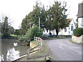
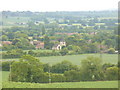
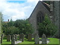
Bourne is an old world for a stream, especially in Southern England. Holybourne is a village just to the north east of Alton. The Holybourne is a stream running from the pond below the church into the river Wey.
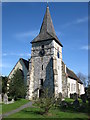
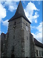
Hope has "The Holybourne is supplied by a spring from the chalk near the upper green sand outcrop. The spring has an elevation of about 350ft., and is close to the churchyard. Formally the water issued from its natural spring almost opposite the west door of the church, and about 20 yds. from it; when the churchyard was enlarged, the spring and its stream were culverted for about 30 or 40 yds. to the pond".
I visited in January 2006 and, on visiting the church, found a small guide book. It mentions springs still to found beneath the altar and at the west end of the nave, and states that the stream was reputed to have healing properties for those with eye troubles.
You may be viewing yesterday's version of this page. To see the most up to date information please register for a free account.
")
")
Do not use the above information on other web sites or publications without permission of the contributor.
Nearby Images from Geograph Britain and Ireland:
©2006(licence)
©2011(licence)
©2011(licence)
©2007(licence)
©2007(licence)
The above images may not be of the site on this page, they are loaded from Geograph.
Please Submit an Image of this site or go out and take one for us!
Click here to see more info for this site
Nearby sites
Key: Red: member's photo, Blue: 3rd party photo, Yellow: other image, Green: no photo - please go there and take one, Grey: site destroyed
Download sites to:
KML (Google Earth)
GPX (GPS waypoints)
CSV (Garmin/Navman)
CSV (Excel)
To unlock full downloads you need to sign up as a Contributory Member. Otherwise downloads are limited to 50 sites.
Turn off the page maps and other distractions
Nearby sites listing. In the following links * = Image available
2.3km ENE 79° Binsted Holy Well* Holy Well or Sacred Spring (SU755417)
4.7km NNE 25° Sheephouse Copse* Round Barrow(s) (SU751455)
4.9km E 81° Binsted Cursus Cursus (SU7842)
8.9km SSW 200° East Tisted Bowl Barrow Round Barrow(s) (SU70263281)
11.6km NNW 340° Mapledurwell Bowl Barrow* Round Barrow(s) (SU691521)
12.0km NW 321° Hackwood Park Barrows* Round Barrow(s) (SU6543050410)
12.1km E 93° Frensham Common Barrows* Barrow Cemetery (SU85334070)
12.1km NE 48° Heath Brow Barrows* Barrow Cemetery (SU82184937)
13.6km NE 50° Caesar's Camp (Hampshire)* Hillfort (SU835501)
14.3km ESE 120° Wishing Well at Waggoners Wells* Holy Well or Sacred Spring (SU857342)
14.5km ENE 73° St. Mary's Well (Compton)* Holy Well or Sacred Spring (SU870457)
14.5km ENE 63° Badshot Lea* Long Barrow (SU86084793)
15.1km ENE 71° Botany Hill Camp Hillfort (SU875462)
15.2km NW 308° Basingstoke Cursus Cursus (SU611505)
15.4km NE 49° Bat's Hogsty* Misc. Earthwork (SU84685152)
15.6km WSW 252° Oliver's Battery* Ancient Village or Settlement (SU58413620)
15.6km ENE 72° Soldier's Ring* Hillfort (SU880462)
16.0km E 80° Tilford Barrows Barrow Cemetery (SU889443)
16.3km SSW 211° Pleasington Cemetery Bronze Age Cremation Site* Artificial Mound (SU649272)
16.5km ENE 78° Crooksbury Common Barrows* Barrow Cemetery (SU893450)
16.5km ENE 75° Culverswell Barrow* Round Barrow(s) (SU892456)
16.6km NW 315° Winklebury Camp (Hampshire)* Hillfort (SU613528)
16.8km S 171° St. Mary's Well (Sheet)* Holy Well or Sacred Spring (SU761246)
17.4km SW 217° Monument to a Horse* Modern Stone Circle etc (SU62972716)
18.2km NNW 341° Bullsdown Camp* Hillfort (SU67085838)
View more nearby sites and additional images


 We would like to know more about this location. Please feel free to add a brief description and any relevant information in your own language.
 Wir möchten mehr über diese Stätte erfahren. Bitte zögern Sie nicht, eine kurze Beschreibung und relevante Informationen in Deutsch hinzuzufügen.
 Nous aimerions en savoir encore un peu sur les lieux. S'il vous plaît n'hesitez pas à ajouter une courte description et tous les renseignements pertinents dans votre propre langue.
 Quisieramos informarnos un poco más de las lugares. No dude en añadir una breve descripción y otros datos relevantes en su propio idioma.